Atacama
Desert & Altiplano, Chile
Explorations in
Atacama
Activity
Difficulty
Areas
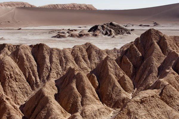
Huayra
Cuenca del salar
-
 Hike
Hike -
Easy
-
Half-day
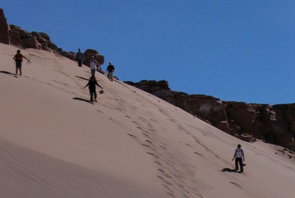
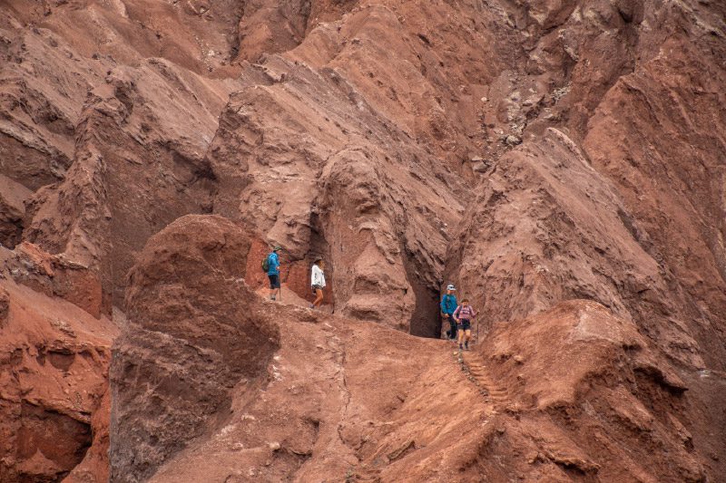
We take a van to the Mars Valley in the Salt Mountain Range, where we begin a walk with views to the different mountain ranges...
More details >Huayra


-
Exploration Path
We take a van to the Mars Valley in the Salt Mountain Range, where we begin a walk with views to the different mountain ranges in the region and felling the wind of the area. We descend through sand dunes and continue walking across the valley, where the van will be waiting to take us back.
Please note: Not available on Mondays.
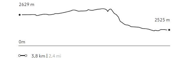
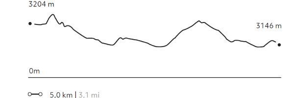
59 m 194 ft
-204 m -669 ft
2.790 m 9.154 ft
2.614 m 8.574 ftElevation Profile
Cornisas
Cuenca del salar
-
Hike
-
Moderate
-
Half-day
We take a van to the Catarpe Valley, where we will walk along the edges of the Salt Mountain Range, with views to the oasis...
More details >Cornisas

-
Exploration Path
We take a van to the Catarpe Valley, where we will walk along the edges of the Salt Mountain Range, with views to the oasis, the salt field and the mountain ranges that define the geography of this destination. We then cross different dunes of the Mars Valley and return by van.
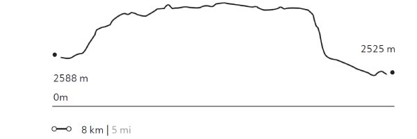
224 m 735 ft
-279 m -915 ft
2.710 m 8.889 ft
2.514 m 8.246 ftElevation Profile
Matancilla
Quebradas Intermedias
-
Hike
-
Easy
-
Half-day
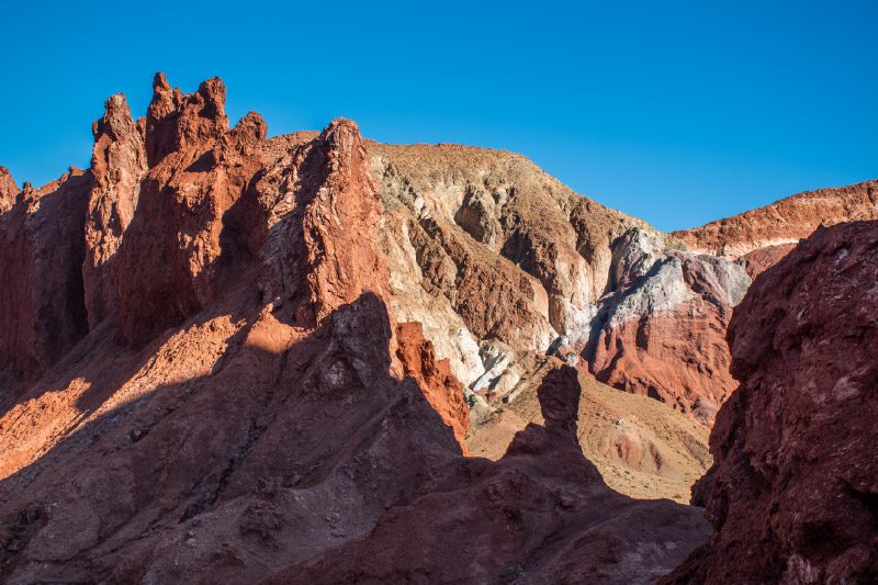
We take a van to the Domeyko Mountain Range where we walk following a creek that used to be a route for gathering and bartering caravans...
More details >Matancilla
-
Exploration Path
We take a van to the Domeyko Mountain Range where we walk following a creek that used to be a route for gathering and bartering caravans. The walk ends at the Rainbow Valley formed by huge multicolored walls of mineral-rich soils. We return by van.
204 m 669 ft
-263 m -863 ft
3.231 m 10.600 ft
3.134 m 10.282 ftElevation Profile
Wanaku
Quebradas Intermedias
-
Hike
-
Moderate
-
Full-day
We take a van to the Domeyko Mountain Range, where we walk through trails that were formerly used as transit and bartering routes...
More details >Wanaku
-
Exploration Path
We take a van to the Domeyko Mountain Range, where we walk through trails that were formerly used as transit and bartering routes and where we can still see remains of the Atacameño culture. We continue to the Rainbow Valley, a place with huge multicolored walls that explain the geological shaping of the Atacama region.
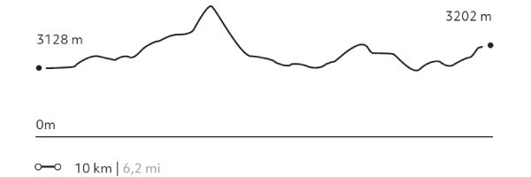
410 m 1345 ft
-336 m -1102 ft
3.292 m 10.798 ft
3.198 m 10.489 ftElevation Profile
Incahuasi
Quebradas Intermedias
-
Hike
-
Advanced
-
Full-day
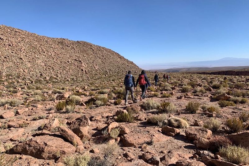
We start walking in an old farmhouse at the foot of the volcanoes of the Andes mountain range. We will enter the Jorquencal gorge...
More details >Incahuasi

-
Exploration Path
We start walking in an old farmhouse at the foot of the volcanoes of the Andes mountain range. We will enter the Jorquencal gorge where we will explore the varied vegetation, history and study of the Andean cat in the Puritama reserve. After crossing a varied landscape we will arrive at the Puritama hot springs, to rest there. Return by van to Explora.
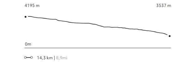
181 m 594 ft
-832 m -2.730 ft
4.195 m 13.763 ft
3.537 m 11.604 ftElevation Profile
Volcán Blanco
Altiplano
-
Hike
-
Moderate
-
Full-day
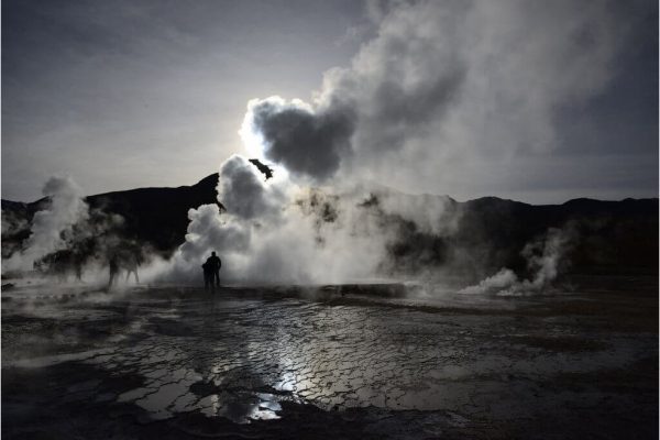
We take a van to the Tatio Geysers, where we first walk up and then down a creek to reach an unknown warm water river, the Blanco River...
More details >Volcán Blanco
-
Exploration Path
We take a van to the Tatio Geysers, where we first walk up and then down a creek to reach an unknown warm water river, the Blanco River. We walk along the river’s bed near geysers and mineral formations unique to this geological landscape.
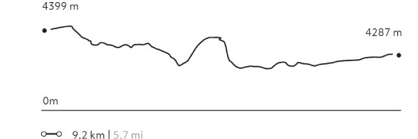
208 m 682 ft
-270 m -886 ft
4.379 m 14.367 ft
4.226 m 13.865 ftElevation Profile
Peñaliri
Quebradas Intermedias
-
Hike
-
Moderate
-
Full-day
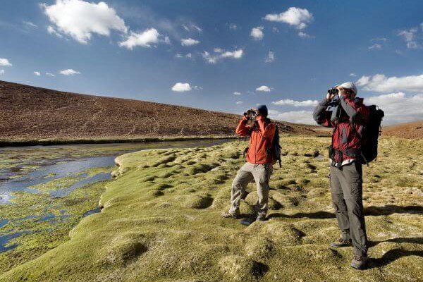
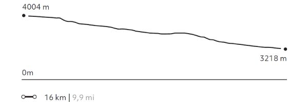
We take a van to Machuca, an Andean Plateau village. We begin exploring a wetland and then walk along a creek to the Grande River...
More details >Peñaliri
-
Exploration Path
We take a van to Machuca, an Andean Plateau village. We begin exploring a wetland and then walk along a creek to the Grande River. In this exploration we can see fauna and typical Andean farming terraces. We have lunch at Peñaliri, an abandoned village.
*Temporarily unavailable. Consult other exploration options with your Explora guide at the destination.
273 m 896 ft
-1.056 m -3.465 ft
4.012 m 13.163 ft
3.218 m 10.558 ftElevation Profile
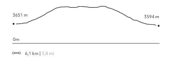
Kimal
Montaña
-
High Mountain Ascent
-
Moderate
-
Full-day
We ride a van for two hours to the Domeyko Mountain Range, until we reach the Kimal hill, the source of one of the most iconic Atacameño...
More details >Kimal

-
Exploration Path
We ride a van for two hours to the Domeyko Mountain Range, until we reach the Kimal hill, the source of one of the most iconic Atacameño legends. We walk up a steep trail to the summit with panoramic views to the salt field and the mythical Licancabur and Juriques volcanoes. We descend and return to the hotel.
695 m 2.280 ft
-752 m -2.467 ft
4.266 m 13.996 ft
3.594 m 11.791 ftElevation Profile
Toco
Montaña
-
High Mountain Ascent
-
Moderate
-
Half-day
We leave by van and head to the Andes Mountains, an hour from Explora, where we begin ascending...
More details >Toco
-
Exploration Path
We leave by van and head to the Andes Mountains, an hour from Explora, where we begin ascending. We take a steep trail up to the summit with views to Bolivia, Argentina, and the surrounding volcanoes.
*Ideal introduction to high mountain.
327 m 1.073 ft
-324 m -1063 ft
5.610 m 18.406 ft
5.282 m 17.329 ftElevation Profile

Cuchabrache
Cuenca del salar
-
Hike
-
Moderate
-
Half-day
We take a van up to the Catarpe Valley, where we begin ascending the Salt Mountain Range. On the way, we’ll see petroglyphs...
More details >Cuchabrache
-
Exploration Path
We take a van up to the Catarpe Valley, where we begin ascending the Salt Mountain Range. On the way, we’ll see petroglyphs and from the top, we can admire the green valley landscapes contrasting with the colors of Salt and Andes Mountain Ranges. This is an ideal introduction to the Atacama region. We return by van.
*Temporarily unavailable. Consult other exploration options with your Explora guide at the destination.
348 m 1.142 ft
-322 m -1056 ft
2.693 m 8.835 ft
2.504 m 8.215 ftElevation Profile
Corona
Montaña
-
High Mountain Ascent
-
Advanced
-
Full-day
We take a van for two hours up to the base of the Corona Hill. There, we begin ascending through a challenging terrain due to the presence of...
More details >Corona
-
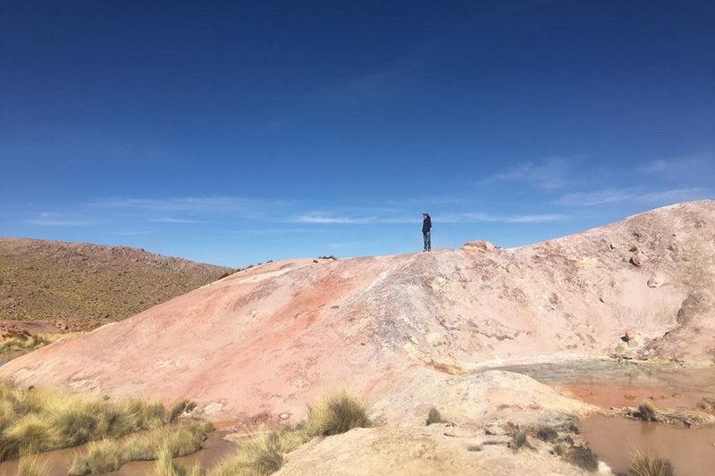
Exploration Path
We take a van for two hours up to the base of the Corona Hill. There, we begin ascending through a challenging terrain due to the presence of crags and loose sand that make movement difficult. At the summit, we see different volcanoes, among them the Lascar with its typical vent.
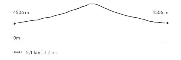
769 m 2522 ft
-769 m -2522 ft
5.262 m 17.259 ft
4.506 m 14.780 ftElevation Profile
Soquete
Montaña
-
High Mountain Ascent
-
Advanced
-
Full-day
We start walking through mud geysers, crossing green valleys with high Andean flora and fauna. After passing through different geological...
More details >Soquete
-
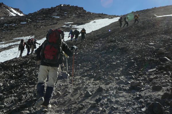
Exploration Path
We start walking through mud geysers, crossing green valleys with high Andean flora and fauna. After passing through different geological formations we reach the needle, its particular summit formed by eruptions and carved by the erosion of wind and water.
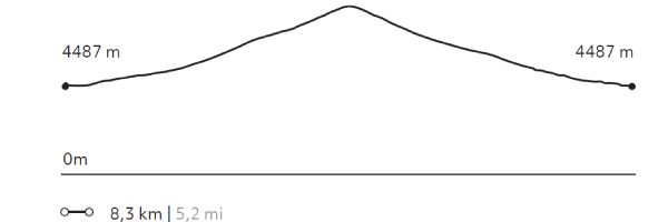
883 m 2896 ft
-883 m -2896 ft
5.366 m 17.600 ft
4.487 m 14.717 ftElevation Profile
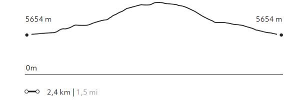
Sairecabur
Montaña
-
High Mountain Ascent
-
Expert
-
Full-day
After a one-and-a-half hour drive by van, we reach the Sairecabur Volcano’s caldera, where we begin ascending. We walk through rocks...
More details >Sairecabur

-
Exploration Path
After a one-and-a-half hour drive by van, we reach the Sairecabur Volcano’s caldera, where we begin ascending. We walk through rocks, stones and loose crags and cross a former sulfur mine before taking the final steep hike.
We will reach the highest point of our explorations at the summit of the "mountain of rain", the meaning of its name.
294 m 965 ft
-292 m -958 ft
5.984 m 19.633 ft
5.654 m 18.550 ftElevation Profile
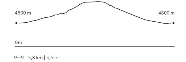
Colorado
Montaña
-
High Mountain Ascent
-
Expert
-
Full-day
We take a van during two hours up to the base of the Colorado Volcano to begin ascending an increasingly steep slope...
More details >Colorado
-
Exploration Path
We take a van during two hours up to the base of the Colorado Volcano to begin ascending an increasingly steep slope. We’ll walk among loose rocks up to the summit. We’ll hike down a scree slope.
934 m 3064 ft
-983 m -3224 ft
5.780 m 18.958 ft
4.800 m 15.744 ftElevation Profile
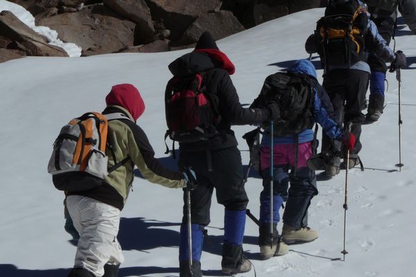
Licancabur
Montaña
-
High Mountain Ascent
-
Expert
-
Full-day
After having conducted several explorations at more than 4,000 m.a.s.l. and gradually acclimatizing our body, we leave by van...
More details >Licancabur
-
Exploration Path
After having conducted several explorations at more than 4,000 m.a.s.l. (13,123 f.a.s.l) and gradually acclimatizing our body, we leave by van from explora to a remote camp in Bolivia on the sixth day. Once settled in the camp, we take a walk across the areas of the Verde and Blanca lagoons, from where we have a good view of the Licancabur Volcano. The next day we wake up early to begin walking before dawn. We use headlamps to light a well-marked trail. Halfway along the ascent we watch the dawn over the Blanca and Verde lagoons. We reach the summit after walking for several hours. From here, we have a view to the crater and the world’s highest lagoon. Descent can be challenging due to steep slopes and unstable terrain. We cross oldInca ruins on the way back.
*This expedition requires a minimum stay of 7 nights and an advanced exploration request of at least 60 days. A visa is required to enter Bolivia.
1.298 m 4.259 ft
-1295 m -4.249 ft
5.916 m 19.409 ft
4.623 m 15.167 ftElevation Profile

-
Other options: