Atacama
Desert & Altiplano, Chile
Explorations in
Atacama
Activity
Difficulty
Areas
San Isidro
Cuenca del salar
-
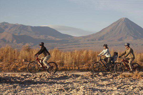
 E-Bike
 -
Moderate
-
Half-day
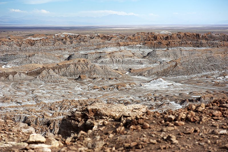
We ride our bicycles to the Catarpe Valley in the Salt Ridge. We pedal through switch paths between canyons...
More details >San Isidro


-
Exploration Path
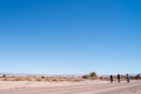
We ride our bicycles to the Catarpe Valley in the Salt Ridge. We pedal through switch paths between canyons made of reddish soil in a place known as Garganta del Diablo (Devil’s Throat). We visit the San Isidro church into a historic area.
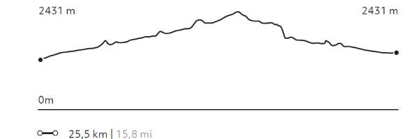
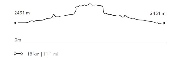
325 m 1.066 ft
-325 m -1.066 ft
2.584 m 8.478 ft
2.431 m 7.976 ftElevation Profile
Tambo
Cuenca del salar
-
E-Bike
-
Advanced
-
Half-day
We bike ride to the Catarpe Valley. We ride up to Cuchabrache, through an old road that crosses the Salt Mountain Range...
More details >Tambo

-
Exploration Path
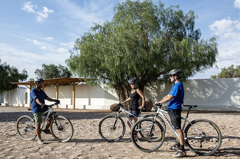
We bike ride to the Catarpe Valley. We ride up to Cuchabrache, through an old road that crosses the Salt Mountain Range. We ride through plaster and crystallized salt creeks. This exploration includes seeing part of the local culture and petroglyphs, as well as the San Isidro church.
*Temporarily unavailable. Consult other exploration options with your Explora guide at the destination.
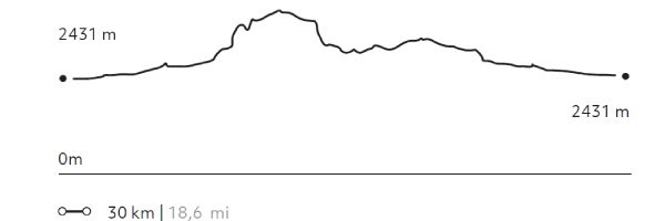
568 m 1.864 ft
-568 m -1.864 ft
2.690 m 8.825 ft
2.431 m 7.976 ftElevation Profile
Reserva Tatio
Altiplano
-
Overland
-
Easy
-
Half-day
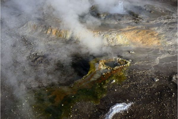
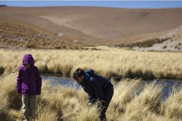
We take a van to the Tatio Geysers. Along the way, an important part of the Andean Plateau fauna –including vicuñas, flamingos, foxes...
More details >Reserva Tatio


-
Exploration Path
We take a van to the Tatio Geysers. Along the way, an important part of the Andean Plateau fauna –including vicuñas, flamingos, foxes, and others– can be appreciated. We walk across the reserve feeling the inner activities of the land with views to the Andes Mountain Range and the hot water springs from where steam rises. We return by van.
Kunza
Cuenca del salar
-
Overland
-
Easy
-
Half-day
In this exploration we learn about the Atacameño history and culture. We start with a guided tour of an archaeological deposit...
More details >Kunza
-
Exploration Path
In this exploration we learn about the Atacameño history and culture. We start with a guided tour of an archaeological deposit where we can see ceramic pieces and other historical artifacts fit for a museum. Later on, we move on to the village of Tulor, one of the first settlements. We end the exploration at the mythical desert bookstore.
Gran Salar
Cuenca del salar
-
Overland
-
Easy
-
Half-day
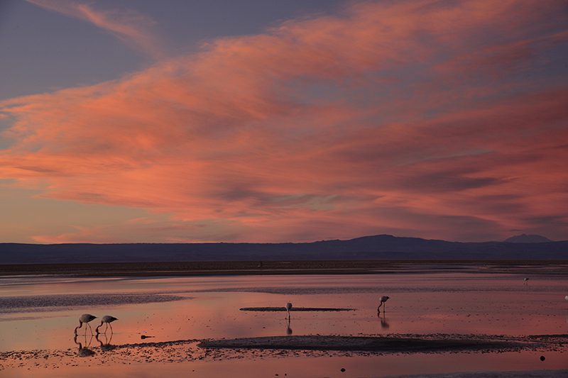
We leave in a van to Toconao, located to the south of San Pedro de Atacama. We walk to the village square and then through an area...
More details >Gran Salar
-
Exploration Path
We leave in a van to Toconao, located to the south of San Pedro de Atacama. We walk to the village square and then through an area of vegetable gardens. We finally take a van to the Chaxa Lagoon, located in the Los Flamencos National Reserve, an ideal place for bird watching within Atacama’s Salt Flat.
Quebradas
Quebradas Intermedias
-
Overland
-
Easy
-
Half-day
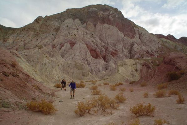
We take a van to the Yerbas Buenas archaeological site located in the Domeyko Mountain Range. Here we can see...
More details >Quebradas
-
Exploration Path
We take a van to the Yerbas Buenas archaeological site located in the Domeyko Mountain Range. Here we can see different styles of petroglyphs.
We continue to the Rainbow Valley, where a special formation with varied shades of colors welcomes us to walk through the valley.
Cordillera de la Sal
Cuenca del salar
-
Overland
-
Easy
-
Half-day
We take a van to the Salt Mountain Range to see typical desert landscapes: open reddish clay grounds, sand dunes...
More details >Cordillera de la Sal
-
Exploration Path
We take a van to the Salt Mountain Range to see typical desert landscapes: open reddish clay grounds, sand dunes, and sedimentary rock formations. We walk up to the highest point of this mountain range to see the panoramic views. We will take a 30 minute walk through one the least known mountainsides of the Salt Ridge.
Altiplano
Altiplano
-
Overland
-
Easy
-
Full-day
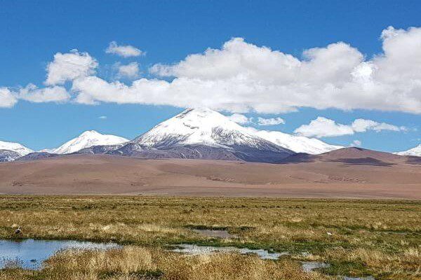
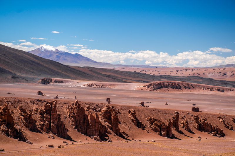
We leave in a van and travel to the borderline with Argentina to appreciate multicolored landscapes and the Andean Plateau Salt Flats....
More details >Altiplano
-
Exploration Path
We leave in a van and travel to the borderline with Argentina to appreciate multicolored landscapes and the Andean Plateau Salt Flats. We explore different ecological floors, which allow us to see the diversity in flora and fauna. We come down from the van to feel what is like to walk over 4,000 m.a.s.l (13,123 f.a.s.l).
Nómade
Altiplano
-
Overland
-
Easy
-
Full-day
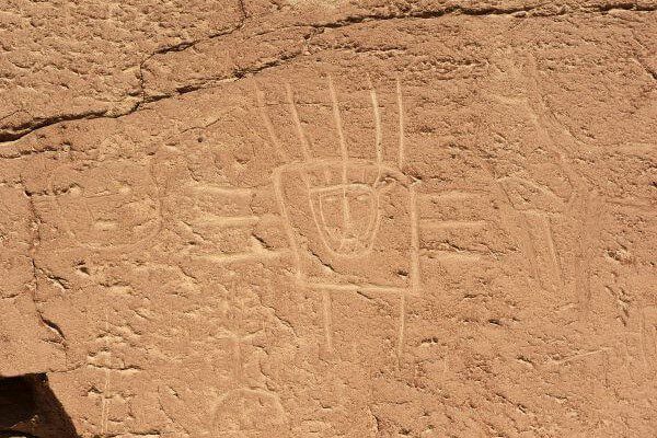
We take a van to Talabre, where we visit the archaeological site of Kezala with petroglyphs as old as 800 - 400 B.C. We continue our journey...
More details >Nómade
-
Exploration Path
We take a van to Talabre, where we visit the archaeological site of Kezala with petroglyphs as old as 800 - 400 B.C. We continue our journey through solitary pathways into the heart of the mountain range in the Andes Plateau. We have lunch in the middle of a natural environment and then come back to Explora.
Lagunas Altiplánicas
Altiplano
-
Overland
-
Easy
-
Full-day
We leave the hotel towards the southern area of the salt flat, from where we will begin to climb towards the slopes of the Andes mountain range. Our first stop will be in the town of Socaire, and then we will continue towards the Piedras Rojas sector in the Aguas Calientes salt flat. Here we will take a short walk with incredible views of the volcanoes and the salt flat. Then we will continue towards the high plateau lagoons of Miscanti and Miñiques, two large and beautiful bodies of water located at 4,200 meters above sea level. We will enjoy a walk surrounded by contrasts between the blue of the water and the reddish mountains of the high plateau. We continue towards our lunch spot and then return to the hotel.
More details >Lagunas Altiplánicas
-
Exploration Path
We leave the hotel towards the southern area of the salt flat, from where we will begin to climb towards the slopes of the Andes mountain range. Our first stop will be in the town of Socaire, and then we will continue towards the Piedras Rojas sector in the Aguas Calientes salt flat. Here we will take a short walk with incredible views of the volcanoes and the salt flat. Then we will continue towards the high plateau lagoons of Miscanti and Miñiques, two large and beautiful bodies of water located at 4,200 meters above sea level. We will enjoy a walk surrounded by contrasts between the blue of the water and the reddish mountains of the high plateau. We continue towards our lunch spot and then return to the hotel.
Catarpe
Cuenca del salar
-
Bike
-
Easy
-
Half-day
We bike ride to the San Pedro River and follow its course to Catarpe. We go through the Quitor pukará...
More details >Catarpe
-
Exploration Path
We bike ride to the San Pedro River and follow its course to Catarpe. We go through the Quitor pukará, an old fortress, and cross the Garganta del Diablo (Devil’s Throat), a canyon inside the Salt Mountain Range with zigzagging paths between striking rock formations. We return through the same road.
244 m 801 ft
-244 m -801 ft
2.546 m 8.353 ft
2.431 m 7.976 ftElevation Profile
Láscar
Montaña
-
High Mountain Ascent
-
Moderate
-
Full-day
We take a van for two hours entering the altiplano of the Andes Mountain Range. At the base of the active Láscar volcano we begin our ascent...
More details >Láscar

-
Exploration Path
We take a van for two hours entering the altiplano of the Andes Mountain Range. At the base of the active Láscar volcano we begin our ascent through a soft terrain and gradually climb. At the summit we will have a wide view with different volcanoes and the Salar de Atacama basin.
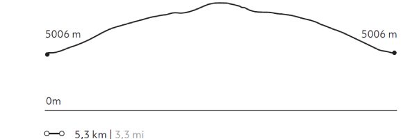
594 m 1.949 ft
-594 m -1.949 ft
5.592 m 18.346 ft
5.006 m 16.424 ftElevation Profile
Kezar
Quebradas Intermedias
-
Hike
-
Easy
-
Half-day
We start our exploration at the Puritama River creek. We descend to walk along the creek following the river bed between large rock walls...
More details >Kezar

-
Exploration Path
We start our exploration at the Puritama River creek. We descend to walk along the creek following the river bed between large rock walls, shrubs and cacti over an irregular terrain. At the end, we arrive at the Puritama Hot Springs to enjoy the amazing properties of these thermal waters.
231 m 758 ft
-60 m -198 ft
3.538 m 11.605 ft
3.365 m 11.037 ftElevation Profile
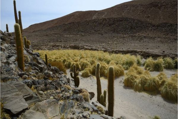
Punta del Inca
Quebradas Intermedias
-
Hike
-
Moderate
-
Half-day
We take a van to Guatín, a grazing area and junction point of the Puritama and Purifica rivers, and source of the Vilama River...
More details >Punta del Inca
-
Exploration Path
We take a van to Guatín, a grazing area and junction point of the Puritama and Purifica rivers, and source of the Vilama River. There, we walk along a canyon known as the Valley of the Cacti due to the existence of giant cacti. We cut cross the canyon crossing the river several times and descending along different waterfalls.
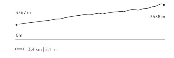
84 m 275 ft
-223 m -731 ft
3.205 m 10.512 ft
3.066 m 10.056 ftElevation Profile
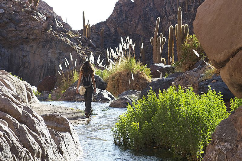
Puritama
Quebradas Intermedias
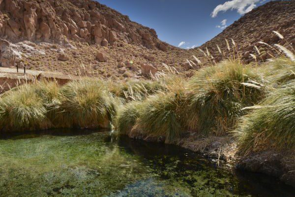
-
Hike
-
Moderate
-
Half-day
We take a van to Guatín where we begin an ascending walk. We walk for almost 30 minutes along giant cacti up to the Puritama River creek...
More details >Puritama
-
Exploration Path
We take a van to Guatín where we begin an ascending walk. We walk for almost 30 minutes along giant cacti up to the Puritama River creek. There, we descend to walk along the river, through rock walls and vegetation. We arrive to the Puritama Hot Springs were we will have some time to relax.
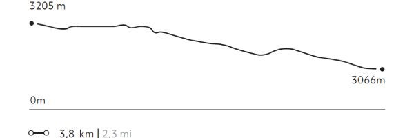
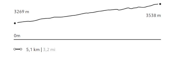
327 m 1.073 ft
-58 m -192 ft
3.538 m 11.608 ft
3.269 m 10.722 ftElevation Profile
-
Other options: