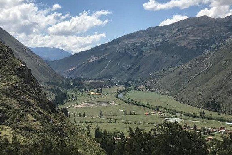
Sacred Valley
Sacred Valley of the Incas, Peru
Explorations in
Sacred Valley
Activity
Difficulty
Areas
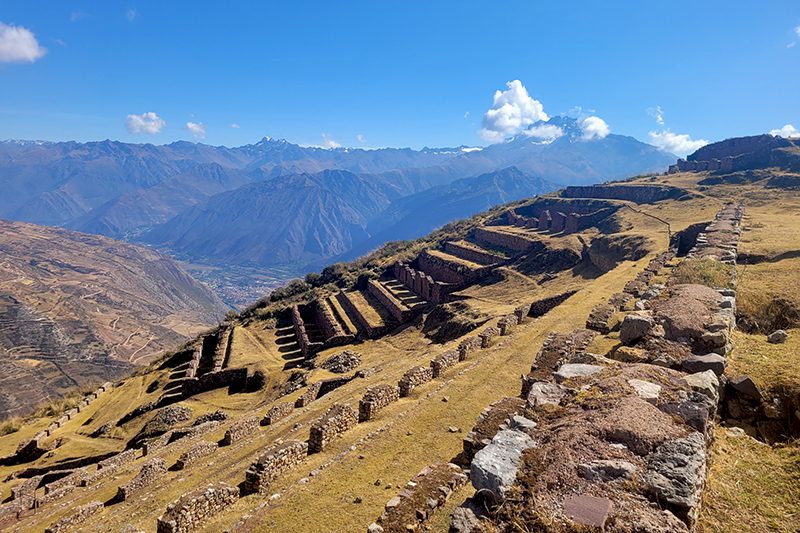
Machu Kolka
Suni
-
 Hike
Hike -
Easy
-
Half-day
We leave by van to Chinchero, where we begin a steep ascent through crops with views of the pampa, the valley of Urquillos and the snowy...
More details >Machu Kolka


-
Exploration Path
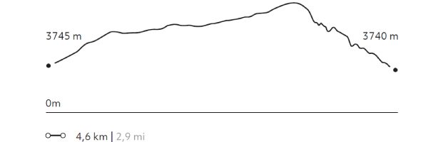
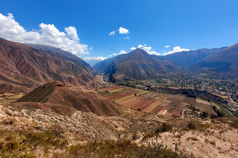
We leave by van to Chinchero, where we begin a steep ascent through crops with views of the pampa, the valley of Urquillos and the snowy peaks that crown the mountains. We walk to the Machu Kolka archaeological center, formerly used as a product storage warehouse. We explore the place and enjoy a privileged view of the valley. We return to explora by van.
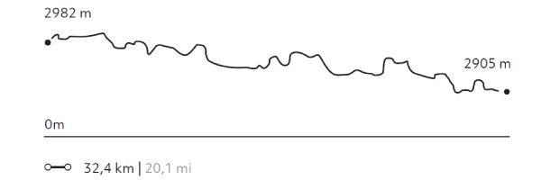
236 m 774 ft
-243 m -797 ft
3.933 m 12.904 ft
3.740 m 12.270 ftElevation Profile
Moray
Suni

-
Hike
-
Easy
-
Half-day
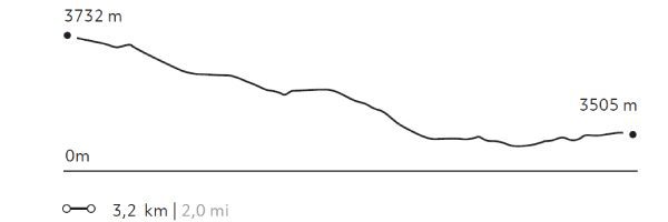
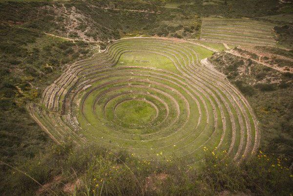
The trail begins at a farming community located amidst hills and goes down to the Inca remains of Moray, a laboratory of experimental...
More details >Moray
-
Exploration Path
The trail begins at a farming community located amidst hills and goes down to the Inca remains of Moray, a laboratory of experimental farming where different microclimates are used to grow crops.
76 m 248 ft
-302 m -991 ft
3.732 m 12.244 ft
3.477 m 11.407 ftElevation Profile
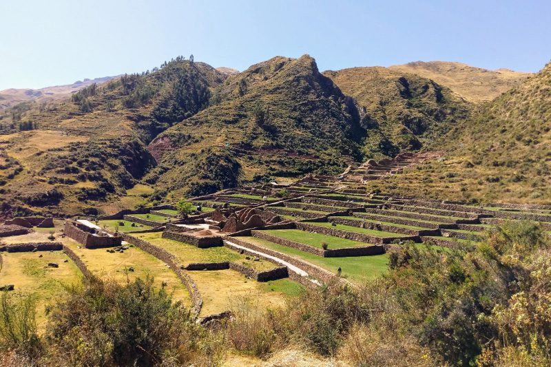
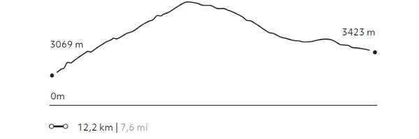
Senderito de Pisaq
Suni
-
Hike
-
Moderate
-
Full-day
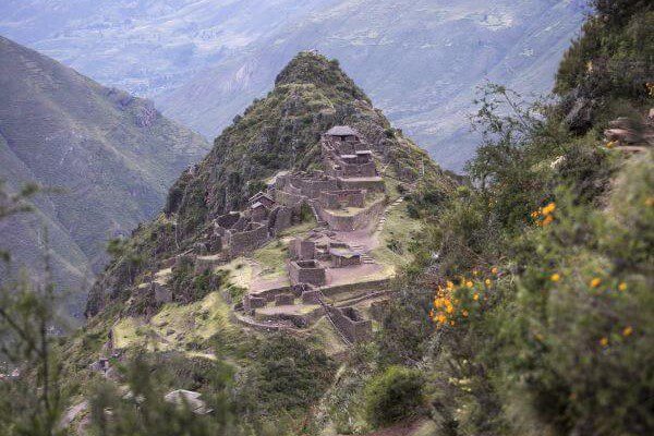
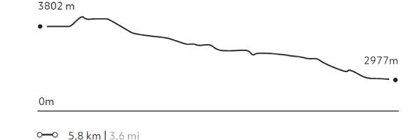
We descend from the mountains to the remains of Pisaq. We will use one of our alternative routes to access the back of the remains...
More details >Senderito de Pisaq

-
Exploration Path
We descend from the mountains to the remains of Pisaq. We will use one of our alternative routes to access the back of the remains, which provides for a unique view. This exploration is recommended for every traveler wishing to enjoy an altitude landscape that calls for contemplation.
191 m 627 ft
-1.013 m -3.323 ft
3.871 m 12.700 ft
2.977 m 9.767 ftElevation Profile
Maras Plateau
Suni
-
Hike
-
Moderate
-
Full-day
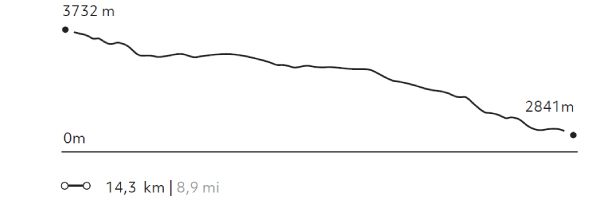
The trail begins at a farming community located amidst hills and goes down to the Inca remains of Moray, from where it continues to...
More details >Maras Plateau
-
Exploration Path
The trail begins at a farming community located amidst hills and goes down to the Inca remains of Moray, from where it continues to the colonial town of Maras. We see a piece of history in every corner. Afterwards, the trail descends to the bottom of the Sacred Valley and goes through the salt mines. The track crosses barley and potato fields and other crops.
170 m 558 ft
-1.047 m -3.435 ft
3.732 m 12.244 ft
2.841 m 9.321 ftElevation Profile
Amor Violento
Suni
-
Hike
-
Moderate
-
Full-day
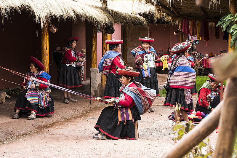
We begin with a visit to the community of Cúper Bajo, where a group of weavers teach us their work and culture. Next, we walk up the slope...
More details >Amor Violento
-
Exploration Path
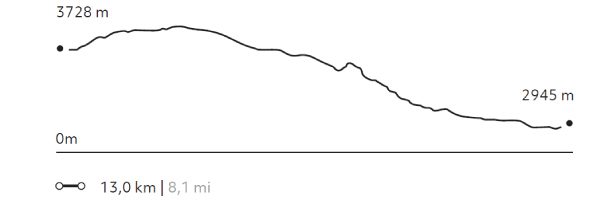
We begin with a visit to the community of Cúper Bajo, where a group of weavers teach us their work and culture. Next, we walk up the slope of a large hill through agricultural terraces, the valley and the town of Chinchero. We descend to Chinchero and the archaeological site. From there, we take an Inca road down to the valley. We have lunch at a viewpoint and continue descending until we reach Explora.
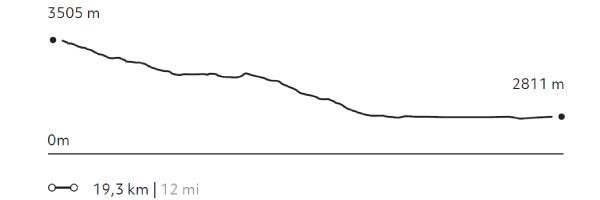
590 m 1.936 ft
-1.387 m -4.551 ft
3.992 m 13.097 ft
2.945 m 9.662 ftElevation Profile
La Verónica
Puna
-
Hike
-
Moderate
-
Full-day
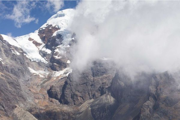
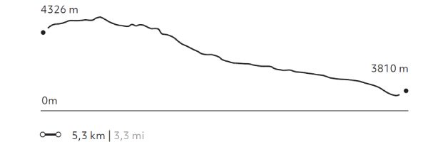
This hiking takes us through a reserve aimed at preserving forests and endangered birds. In the dry season, the snow-capped Verónica...
More details >La Verónica
-
Exploration Path
This hiking takes us through a reserve aimed at preserving forests and endangered birds. In the dry season, the snow-capped Verónica hill and the mountains surrounding it are the main attractions. During the rainy season, views may be obstructed by clouds, but then the ground steals the limelight.
164 m 538 ft
-680 m -2.231 ft
4.418 m 14.495 ft
3.810 m 12.500 ftElevation Profile
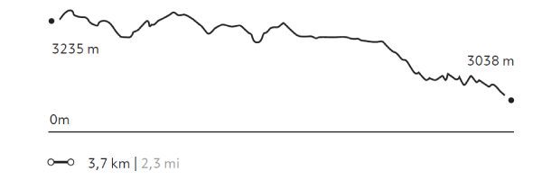
Arin
Quechua
-
Hike
-
Easy
-
Half-day
Our hike begins in Huarán, on a narrow path that runs along an irrigation channel and different crops, with views of the valley and its ravines...
More details >Arin
-
Exploration Path
Our hike begins in Huarán, on a narrow path that runs along an irrigation channel and different crops, with views of the valley and its ravines; among them, that of Urquillos. We continue skirting the channel through forests of eucalyptus and smallholdings, until we come to a path by which we descend. Finally, we reach the community of Arín. We return to Explora by van.
* Not recommended for travelers with fear of heights.
332 m 1.089 ft
-529 m -1.736 ft
3.253 m 10.673 ft
3.038 m 9.967 ftElevation Profile
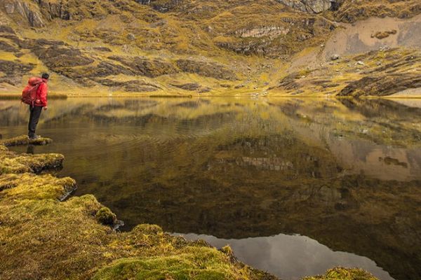
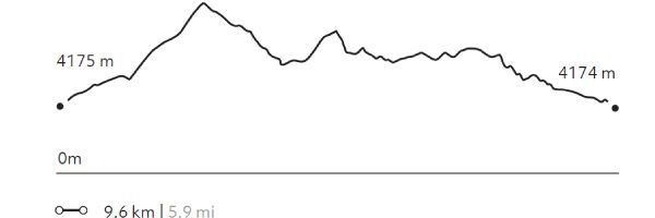
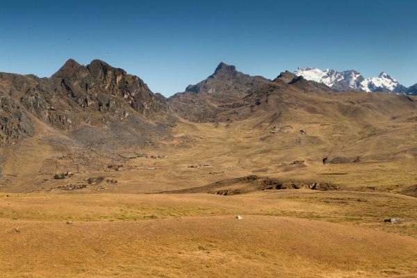
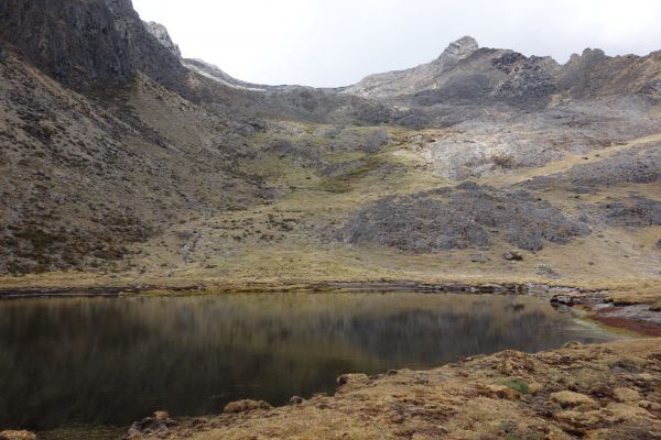
5 Lagunas
Puna
-
Hike
-
Moderate
-
Full-day
This walk begins at an isolated community in the heights of the Andes. From there, the trail goes up to a broad pass from...
More details >5 Lagunas
-
Exploration Path
This walk begins at an isolated community in the heights of the Andes. From there, the trail goes up to a broad pass from where to observe the snow capped Sawasiray and other snowcapped peaks. The descent takes us through a ravine with llama and alpaca herds, passing beside several lagoons that reflect the large snowcapped peak in the background and the yellow-colored mountains.
432 m 1.417 ft
-435 m -1.427 ft
4.357 m 14.295 ft
4.174 m 13.694 ftElevation Profile
Lloclla
Puna
-
Hike
-
Moderate
-
Full-day
This mountain walk follows tracks used by local shepherds among lagoons serving as water deposits to sustain the area’s rural lifestyle...
More details >Lloclla
-
Exploration Path
This mountain walk follows tracks used by local shepherds among lagoons serving as water deposits to sustain the area’s rural lifestyle between the valleys of Lamay and Pisac. Old mountain trails, mild slopes, views, and people, among others, invite travelers to relax, walk calmly, breathe deeply and enjoy different perspectives and colors.
432 m 1.417 ft
-583 m -1.913 ft
4.396 m 14.423 ft
4.033 m 13.232 ftElevation Profile
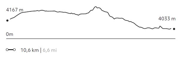
Tastayoc
Puna
-
Hike
-
Advanced
-
Full-day
We begin in the altitude, through a pastureland highly isolated from the rest of the valley. The trail includes several lagoons...
More details >Tastayoc

-
Exploration Path
We begin in the altitude, through a pastureland highly isolated from the rest of the valley. The trail includes several lagoons, some with turquoise waters due to thawing, and others with transparent waters, allowing travelers to learn about high-mountain water ecosystems.
892 m 2.927 ft
-1.085 m -3.560 ft
4.687 m 15.377 ft
3.786 m 12.421 ftElevation Profile
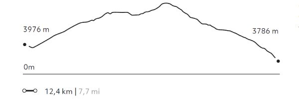
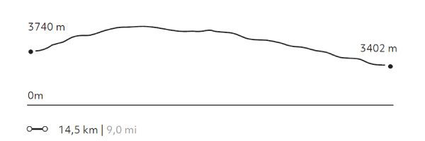
Stream to Cusco
Puna

-
Hike
-
Advanced
-
Full-day
The trail crosses the mountains that separate the Sacred Valley from Cusco and reaches the Town Square of the Inca’s imperial city. This road...
More details >Stream to Cusco
-
Exploration Path
The trail crosses the mountains that separate the Sacred Valley from Cusco and reaches the Town Square of the Inca’s imperial city. This road simulates the journey followed by the Incas and Spanish conquerors more than 500 years ago. Before completing the exploration, there is a guided tour to the huge walls of the Saqsaywaman and its archaeological and ceremonial centers.
630 m 2.067 ft
-968 m -3.176 ft
4.281 m 14.045 ft
3.402 m 11.161 ftElevation Profile
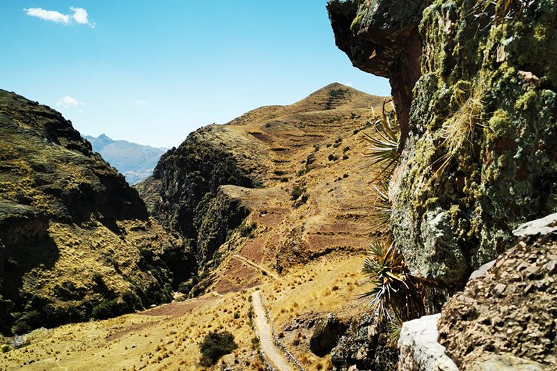
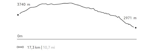
Huchuy Qosqo
Puna
-
Hike
-
Advanced
-
Full-day
This exploration offers breathtaking views to lagoons at different altitudes, to the farmlands of Chinchero and to the valleys. To reach...
More details >Huchuy Qosqo
-
Exploration Path
This exploration offers breathtaking views to lagoons at different altitudes, to the farmlands of Chinchero and to the valleys. To reach the remains of the Huchuy Qosqo Palaces, it goes down an Inca trail. Once in the remains, you cannot miss lying down in the gardens, taking a rest and enjoying the view towards Sacred Valley.
968 m 3.176 ft
-1.738 m -5.702 ft
4.318 m 14.167 ft
2.971 m 9.747 ftElevation Profile
Pachatusan
Puna
-
Hike
-
Expert
-
Full-day
We begin our ascent by a path of agricultural and livestock use. During this exploration, we can see Cerro Pachatusan, considered in Inca culture...
More details >Pachatusan

-
Exploration Path
We begin our ascent by a path of agricultural and livestock use. During this exploration, we can see Cerro Pachatusan, considered in Inca culture to be the protector of the world. We walk to an open area with wide views of the Cusco Valley and finally, we descend to the archaeological centers of Pukara and Tipón, where agriculture was developed with an important Inca hydraulic system that is still in use today.
1.344 m 4.409 ft
-991 m -3.251 ft
4.179 m 13.711 ft
3.069 m 10.069 ftElevation Profile
Rio Urubamba
Quechua
-
Bike
-
Easy
-
Half-day
The road used for this exploration goes down the south side of the Urubamba River, a quiet area of cornfields, old haciendas and manors from...
More details >Rio Urubamba

-
Exploration Path
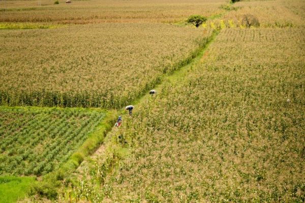
The road used for this exploration goes down the south side of the Urubamba River, a quiet area of cornfields, old haciendas and manors from the 19th and 20th centuries. This bike ride is recommended for families wishing to take a long walk or for those who want to take on a sport.
858 m 2.815 ft
-928 m -3.045 ft
2.996 m 9.829 ft
2.811 m 9.222 ftElevation Profile
Cuesta del Sapo
Quechua
-
Bike
-
Moderate
-
Half-day
From the heights of the Sacred Valley’s slopes we descend over a track in good conditions. The road offers very interesting views to the mountains...
More details >Cuesta del Sapo
-
Exploration Path
From the heights of the Sacred Valley’s slopes we descend over a track in good conditions. The road offers very interesting views to the mountains and the Urubamba river. Once downhill, we will continue bordering the river through an area of cornfields and orchards and densely packed Inca terraces.
163 m 535 ft
-858 m -2.815 ft
3.505 m 11.499 ft
2.811 m 9.222 ftElevation Profile
-
Other options: