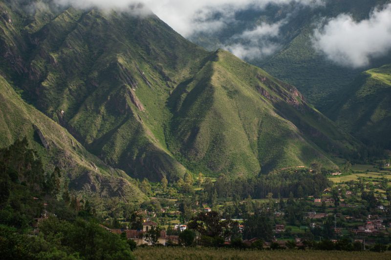
Sacred Valley
Sacred Valley of the Incas, Peru
Explorations in
Sacred Valley
Activity
Difficulty
Areas
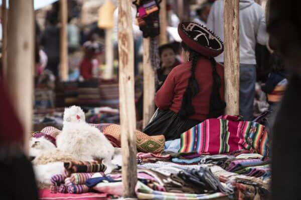
Chinchero
Suni
-
 Overland
 -
Easy
-
Half-day
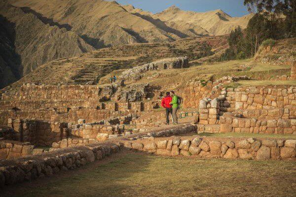
Just 1 hour away from explora, between Urubamba and Cuzco, the village of Chinchero (3762 masl) is believed to be the birthplace...
More details >Chinchero


-
Exploration Path
Just 1 hour away from explora, between Urubamba and Cuzco, the village of Chinchero (3762 masl) is believed to be the birthplace of the Sacred Valley’s textile craftsmanship, as well as a hub for local trade.
This exploration takes travellers through the colonial streets of Chinchero by foot, visiting the village’s adobe church and discovering the unique murals preserved within.
- m - ft
- m - ft
3.860 m 12.664 ft
2.945 m 9.662 ftElevation Profile
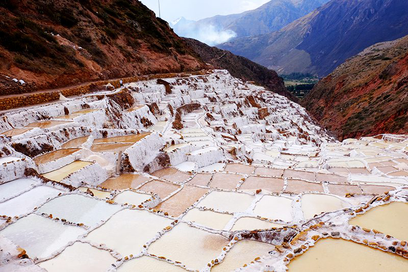
Moray y Salineras
Suni
-
Overland
-
Easy
-
Half-day
Located only 45 min. away from explora (by van), the Maras salt mines are one of the few sites in the world to extract naturally pink salt.
More details >Moray y Salineras
-
Exploration Path
Located only 45 min. away from explora (by van), the Maras salt mines are one of the few sites in the world to extract naturally pink salt. This exploration takes travellers through the open-air salt pools, as well as to the silent village of Maras. Close by, travellers will also find the circular terraces of Moray, once used by the Incas as agricultural laboratories for the empire’s crops, and one of the best-preserved archaeological sites in the valley.
- m - ft
- m - ft
3.733 m 12.247 ft
2.945 m 9.662 ftElevation Profile
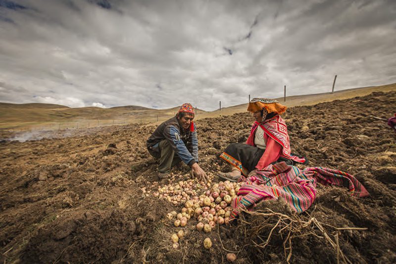
Ayni
Quechua
-
Overland
-
Easy
-
Full-day
We will visit the community of Huayllafara in the valley of Lamay, stopping along the way for a briefing on existing conservation projects...
More details >Ayni
-
Exploration Path
We will visit the community of Huayllafara in the valley of Lamay, stopping along the way for a briefing on existing conservation projects and then reaching the hike’s starting point. Once in the community, we will take part in farm work –based on the Andean calendar– learning about different local plants and crops. We will also get to know farming tools and techniques passed down through generations. Lunch will be prepared by community members using local produce.
Valle de la Papa
Puna
-
Overland
-
Easy
-
Full-day
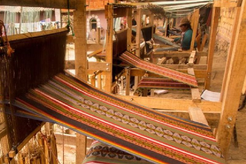
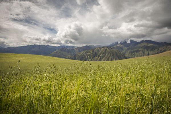
This exploration takes travelers to one of the most fertile areas of the Sacred Valley. We begin by heading toward the Quinsacocha lagoon, a typical landscape of the Cuzco puna, until reaching the community of Chauaytire, where we will walk among and observe the rock paintings of the area's ancient inhabitants. Lastly, we will have the chance to interact with members of the community, who will teach us the millennial art of Andean textiles.
More details >Valle de la Papa
-
Exploration Path
This exploration takes the traveler to one of the most fertile areas in the Sacred Valley. The journey begins towards the Quinsacocha lagoon, a sublime site that features the typical Cusco puna landscape. Going downhill, we will cross the el Valle de la Papa and next, visit the Quechua community of Chahuaytire, a place with an This exploration takes travelers to one of the most fertile areas of the Sacred Valley. We begin by heading toward the Quinsacocha lagoon, a typical landscape of the Cuzco puna, until reaching the community of Chauaytire, where we will walk among and observe the rock paintings of the area's ancient inhabitants. Lastly, we will have the chance to interact with members of the community, who will teach us the millennial art of Andean textiles. textile tradition where we will learn about natural dying and back strap loom techniques. The trip ends with a visit to the stunning archaeological center of Pisaq, a city built on a mountain with hundreds of remarkable hanging farm terraces on its slopes.
- m - ft
- m - ft
4.050 m 13.287 ft
2.945 m 9.662 ftElevation Profile
Pitusiray
Janca
-
High Mountain Ascent
-
Expert
-
Full-day
Van ride to the upper part of Calca city. The hike begins with a sloped ascent following a well-marked winding trail. We go by lagoons...
More details >Pitusiray


-
Exploration Path
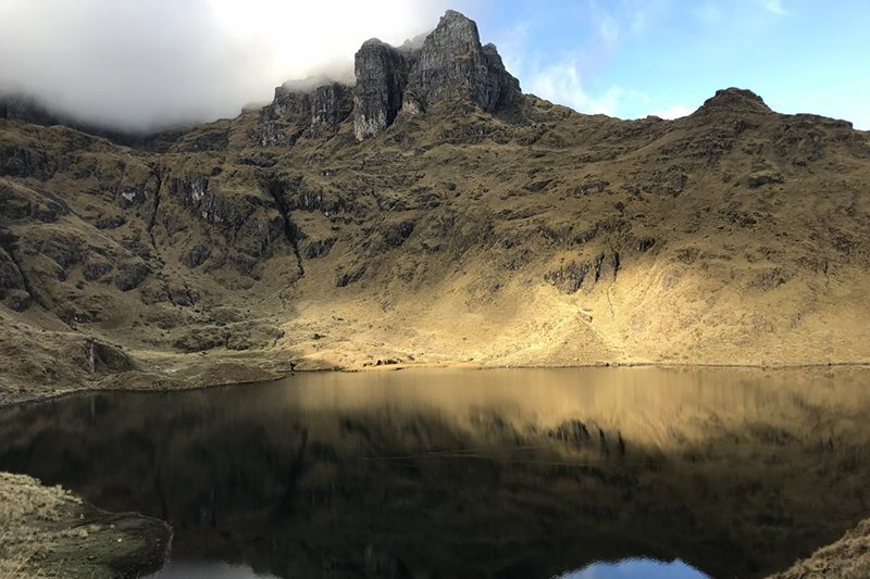
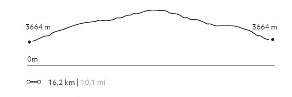
After going on several explorations at over 4,000 m.a.s.l., early in the morning on the fifth day we head to the city of Calca by van. We begin the hike with a steep climb up a well-marked trail, where we pass lagoons and rocky areas where rock-climbing techniques are required. We will have a wonderful view of the Sacred Valley and much of the Vilcanota mountain range from the summit.
This exploration is currently unavailable.
1.752 m 5.748 ft
-1.752 m -5.748 ft
5.012 m 16.444 ft
3.664 m 12.021 ftElevation Profile
La Capilla
Quechua
-
Self Guided
-
Easy
-
Half-day
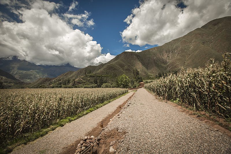
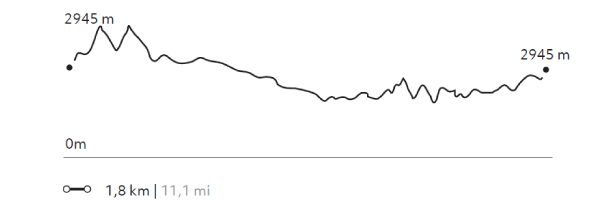
This hike up to the chapel located on the hillside behind the hotel offers views of the valley, cornfields and mountains. The chapel...
More details >La Capilla

-
Exploration Path
This hike up to the chapel located on the hillside behind the hotel offers views of the valley, cornfields and mountains. The chapel is a sample of the religious syncretism of this area where Catholicism and local traditions converge.
143 m 469 ft
-143 m -469 ft
2.948 m 9.672 ft
2.891 m 9.485 ftElevation Profile
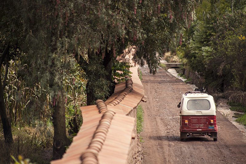
Urquillos
Quechua
-
Self Guided
-
Easy
-
Half-day
A good way to get to know the surroundings of Explora Valle Sagrado and the community of Urquillos, a hike where the active use of...
More details >Urquillos
-
Exploration Path
A good way to get to know the surroundings of Explora Valle Sagrado and the community of Urquillos, a hike where the active use of irrigation channels for local farming can be observed, where the quiet way of life and work prevailing in this area of the Sacred Valley is maintained.
72 m 236 ft
-71 m -233 ft
2.951 m 9.682 ft
2.904 m 9.528 ftElevation Profile
Huayabamba
Quechua
-
Self Guided
-
Easy
-
Half-day
Riding a bicycle through the explora’s surroundings is a good option for getting to know Urquillos, as well as getting to Huayllamba...
More details >Huayabamba
-
Exploration Path
Riding a bicycle through the Explora’s surroundings is a good option for getting to know Urquillos, as well as getting to Huayllamba by following the course of the Urubamba River. This tour shows the farming nature of the area and the contrasts between one locality and the other.
267 m 876 ft
-275 m -902 ft
2.969 m 9.741 ft
2.867 m 9.406 ftElevation Profile
Silvayoc
Quechua
-
Self Guided
-
Easy
-
Half-day
The hike visits archaeological sites with great historical value helping us connect with those who once inhabited the Sacred Valley.
More details >Silvayoc
-
Exploration Path
Explora’s plot is located in Urubamba, considered Peru’s archaeological capital. This 32-hectare area –encompassing four ancient properties– includes archaeological evidence that proves occupation since pre-Incan times. The hike visits archaeological sites with great historical value helping us connect with those who once inhabited the Sacred Valley.
28 m 99 ft
-28 m -99 ft
2.939 m 9.642 ft
2.914 m 9.560 ftElevation Profile
Paru
Puna
-
Hike
-
Moderate
-
Full-day
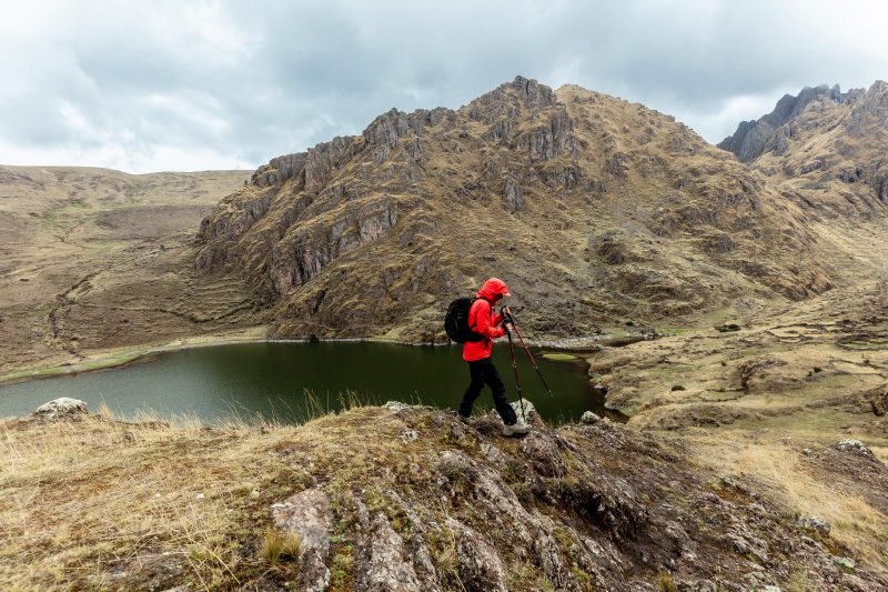
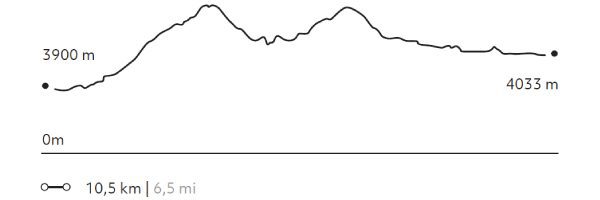
This exploration transports travelers to paths where only shepherds pass. There they will walk to more than 13000 ft. Then, following some water...
More details >Paru


-
Exploration Path
This exploration transports travelers to paths where only shepherds pass. There they will walk to more than 13000 ft. Then, following some water courses, explore the slopes of the mountains and lagoons between ranches of Paru-Paru.
716 m 2.349 ft
-582 m -1.909 ft
4.347 m 14.262 ft
3.900 m 12.795 ftElevation Profile
Huertos de Yucay
Quechua
-
Hike
-
Easy
-
Half-day
The exploration begins at Yucay, the former residence of the prominent Inca rulers Tupac Inca Yupanqui, Huaynacapac and Sayritupac...
More details >Huertos de Yucay
-
Exploration Path
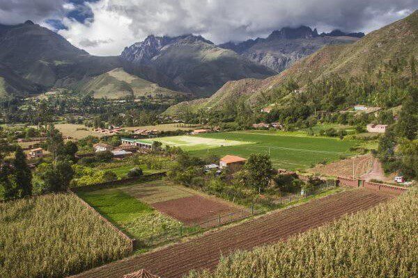
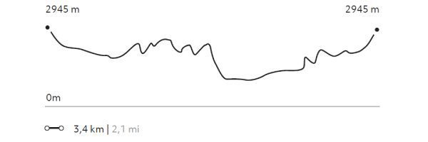
The exploration begins at Yucay, the former residence of the prominent Inca rulers Tupac Inca Yupanqui, Huaynacapac and Sayritupac, and abundant crop fields. The trail takes you to the area’s platforms and crop fields.
224 m 735 ft
-224 m -735 ft
3.051 m 10.010 ft
2.857 m 9.373 ftElevation Profile
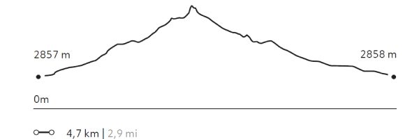
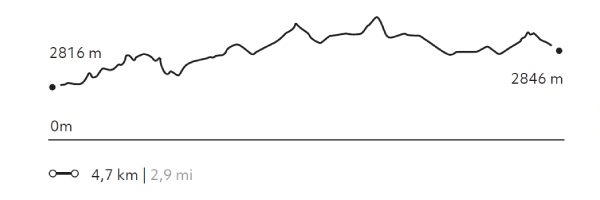
Ollantaytambo
Quechua
-
Hike
-
Easy
-
Half-day
The walk takes us through the living Inca town of Ollantaytambo. The trail passes through the old main gate and over cobblestone streets...
More details >Ollantaytambo
-
Exploration Path
The walk takes us through the living Inca town of Ollantaytambo. The trail passes through the old main gate and over cobblestone streets framed by narrow water channels. After visiting the village, we climb to the archaeological site to see its terraces, the ceremonial center and the Royal Building.
177 m 581 ft
-146 m -479 ft
2.885 m 9.465 ft
2.816 m 9.239 ftElevation Profile
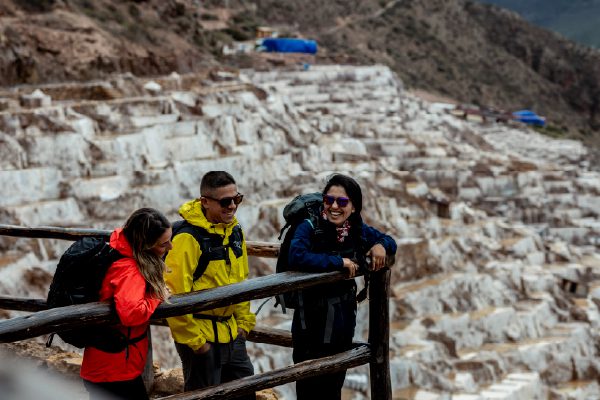
Salineras
Quechua
-
Hike
-
Moderate
-
Half-day
Hiking begins visiting the colonial town of Maras. After crossing the village, the trail descends among potato fields to the community’s salt...
More details >Salineras
-
Exploration Path
Hiking begins visiting the colonial town of Maras. After crossing the village, the trail descends among potato fields to the community’s salt mines.
Not recommended for travelers with fear of heights.
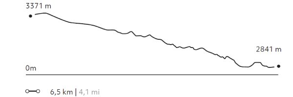
162 m 531 ft
-681 m -2.234 ft
3.371 m 11.060 ft
2.841 m 9.321 ftElevation Profile
Racchi
Suni
-
Hike
-
Easy
-
Half-day
The walk carries you through orchards and communities to familiarize yourself with the rural landscape and its culture. This exploration takes...
More details >Racchi
-
Exploration Path
The walk carries you through orchards and communities to familiarize yourself with the rural landscape and its culture. This exploration takes place at a mean height and offers panoramic views to the Sacred Valley and its snowed capped peaks. It provides a good chance for acclimatization and to understand the area’s geography.
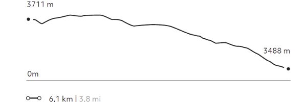
63 m 207 ft
-287 m -942 ft
3.733 m 12.247 ft
3.488 m 11.444 ftElevation Profile
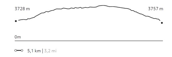
Kaytucha
Suni
-
Hike
-
Moderate
-
Half-day
We begin with a visit to the community of Cúper Bajo where we learn about textile techniques. Then we start our hike, ascending up...
More details >Kaytucha
-
Exploration Path
We begin with a visit to the community of Cúper Bajo where we learn about textile techniques. Then we start our hike, ascending up an agricultural road with panoramic views of lagoons, fields of crops and the town of Chinchero. Finally, we descend to the archaeological complex of Chinchero, where Inca and colonial elements merge. We return to explora by van.
270 m 886 ft
-241 m -791 ft
3.992 m 13.097 ft
3.728 m 12.231 ftElevation Profile
-
Other options: