Atacama
Desert & Altiplano, Chile
Explorations in
Atacama
Activity
Difficulty
Areas
Puri
Quebradas Intermedias
-
 Overland
 -
Easy
-
Half-day
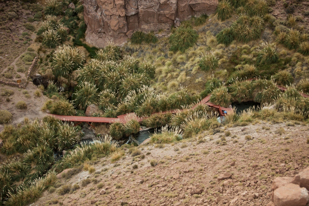
Puri's overland exploration follows the Vilama and Puritama Rivers. Scenic viewpoints lead to a short hike into the Puritama Canyon.
More details >Puri


-
Exploration Path
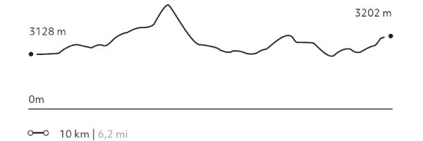
Puri's overland exploration follows the Vilama and Puritama Rivers, vital lifelines in the Atacama Desert. Stops at scenic viewpoints lead to a short hike into the Puritama Canyon, revealing unique vegetation and ancient human traces, and ending with a relaxing dip in our exclusive pools at the Puritama Hot Springs.
87 m 285 ft
-53 m -174 ft
3540 m 11614 ft
3474 m 11398 ftElevation Profile
Ronque
Quebradas Intermedias
-
Hike
-
Moderate
-
Full-day
The hike begins in the upper part of Quebrada Jorquencal, a sector with large cacti and archaeological ruins. From there we descend to the Puritama hot springs. We will enjoy lunch there, before continuing our hike along the Puritama River, in a beautiful canyon of native vegetation home to dozens of birds. Our hike ends in the town of Guatín, where the Puritama and Purifica Rivers converge and give life to the Vilama River.
More details >Ronque


-
Exploration Path
The hike begins in the upper part of Quebrada Jorquencal, a sector with large cacti and archaeological ruins. From there we descend to the Puritama hot springs. We will enjoy lunch there, before continuing our hike along the Puritama River, in a beautiful canyon of native vegetation home to dozens of birds. Our hike ends in the town of Guatín, where the Puritama and Purifica Rivers converge and give life to the Vilama River.
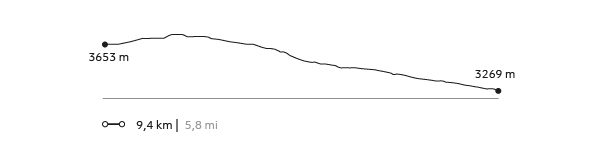
161 m 528 ft
-545 m -1788 ft
3732 m 12241 ft
3269 m 10722 ftElevation Profile
Domeyko
Quebradas Intermedias
-
Hike
-
Moderate
-
Half-day
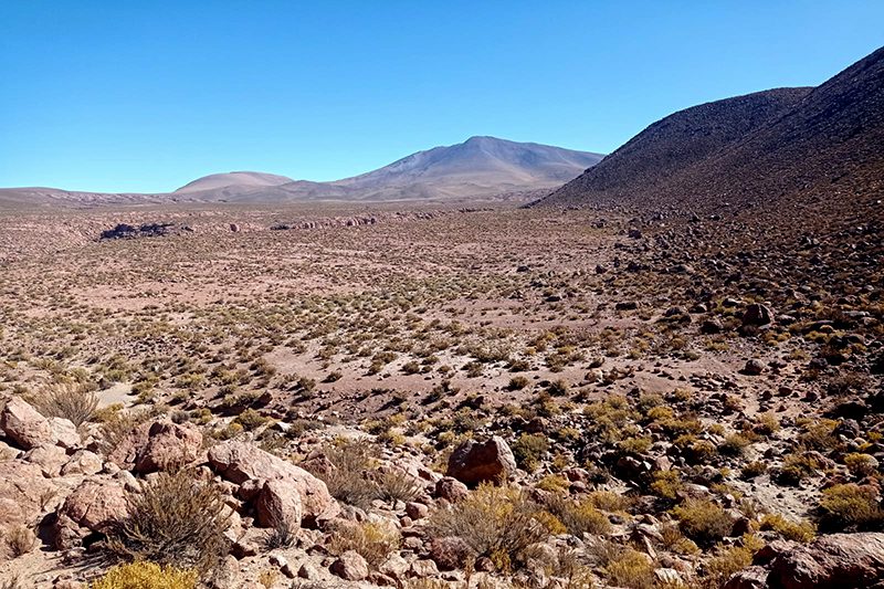
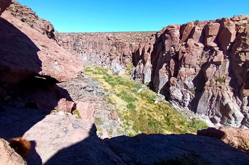
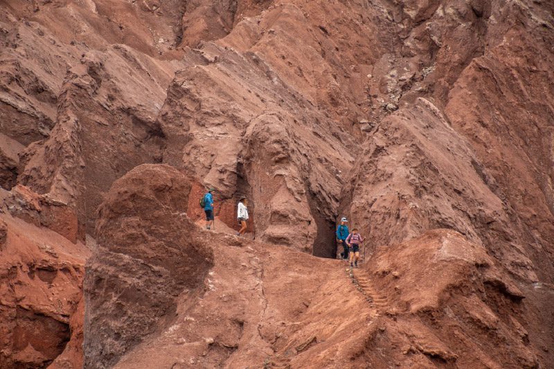
This hike takes place in the Domeyko range, amid great canyons and colors created by the different minerals that make up this mountain range. After getting lost among huge clay walls, we will descend some challenging steps product of the erosion caused by ancient seasonal rivers, and where we will have to use our hands. *Exploration not recommended for people with vertigo or fear of heights.
More details >Domeyko
-
Exploration Path
This hike takes place in the Domeyko range, amid great canyons and colors created by the different minerals that make up this mountain range. After getting lost among huge clay walls, we will descend some challenging steps product of the erosion caused by ancient seasonal rivers, and where we will have to use our hands.
*Exploration not recommended for people with vertigo or fear of heights.
73 m 240 ft
-292 m -958 ft
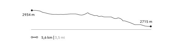
2.934 m 9.626 ft
2.715 m 8.907 ftElevation Profile
Tambores
Quebradas Intermedias
-
Hike
-
Easy
-
Half-day
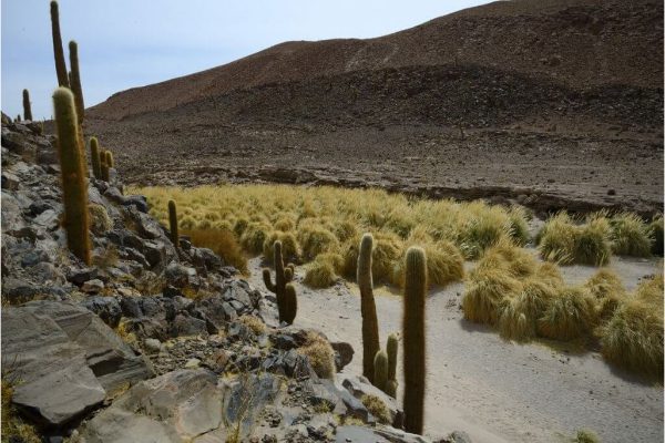
This hike explores the center of the Puritama Conservation Reserve, an area characterized by its great variety of cacti. Along the way we will have a view of the beautiful Quebrada Jorquenal from above, a canyon full of contrasts, vegetation, life and archaeological remains. We descend along a rocky terrain until reaching the Puritama hot springs.
More details >Tambores
-
Exploration Path
This hike explores the center of the Puritama Conservation Reserve, an area characterized by its great variety of cacti. Along the way we will have a view of the beautiful Quebrada Jorquenal from above, a canyon full of contrasts, vegetation, life and archaeological remains. We descend along a rocky terrain until reaching the Puritama hot springs.
118 m 387 ft
-233 m -764 ft
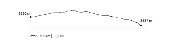
3732 m 12241 ft
3537 m 11601 ftElevation Profile
Kezar
Quebradas Intermedias
-
Hike
-
Easy
-
Half-day
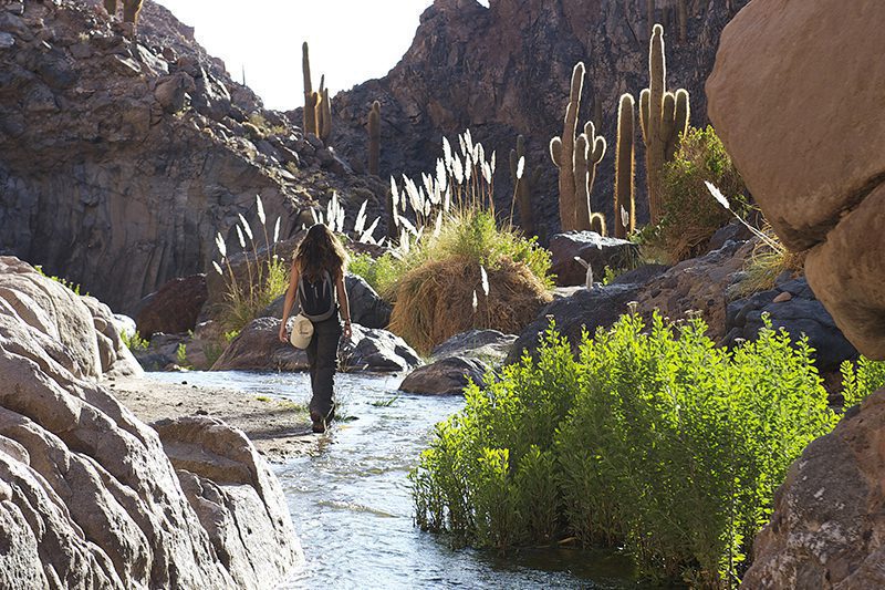
We start our exploration at the Puritama River creek. We descend to walk along the creek following the river bed between large rock walls...
More details >Kezar
-
Exploration Path
We start our exploration at the Puritama River creek. We descend to walk along the creek following the river bed between large rock walls, shrubs and cacti over an irregular terrain. At the end, we arrive at the Puritama Hot Springs to enjoy the amazing properties of these thermal waters.
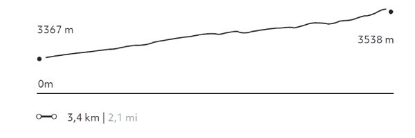
231 m 758 ft
-60 m -198 ft
3.538 m 11.605 ft
3.365 m 11.037 ftElevation Profile
Punta del Inca
Quebradas Intermedias
-
Hike
-
Moderate
-
Half-day
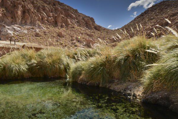
We take a van to Guatín, a grazing area and junction point of the Puritama and Purifica rivers, and source of the Vilama River...
More details >Punta del Inca
-
Exploration Path
We take a van to Guatín, a grazing area and junction point of the Puritama and Purifica rivers, and source of the Vilama River. There, we walk along a canyon known as the Valley of the Cacti due to the existence of giant cacti. We cut cross the canyon crossing the river several times and descending along different waterfalls.
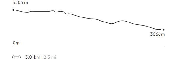
84 m 275 ft
-223 m -731 ft
3.205 m 10.512 ft
3.066 m 10.056 ftElevation Profile
Puritama
Quebradas Intermedias
-
Hike
-
Moderate
-
Half-day
We take a van to Guatín where we begin an ascending walk. We walk for almost 30 minutes along giant cacti up to the Puritama River creek...
More details >Puritama
-
Exploration Path
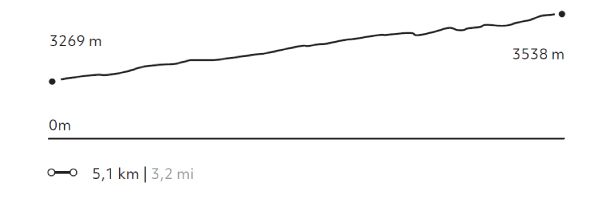
We take a van to Guatín where we begin an ascending walk. We walk for almost 30 minutes along giant cacti up to the Puritama River creek. There, we descend to walk along the river, through rock walls and vegetation. We arrive to the Puritama Hot Springs were we will have some time to relax.
327 m 1.073 ft
-58 m -192 ft
3.538 m 11.608 ft
3.269 m 10.722 ftElevation Profile
Matancilla
Quebradas Intermedias
-
Hike
-
Easy
-
Half-day
We take a van to the Domeyko Mountain Range where we walk following a creek that used to be a route for gathering and bartering caravans...
More details >Matancilla
-
Exploration Path
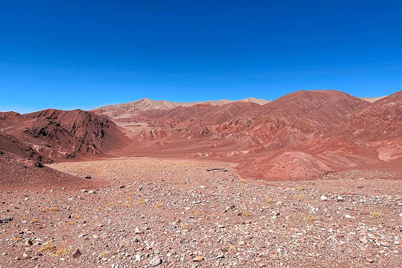
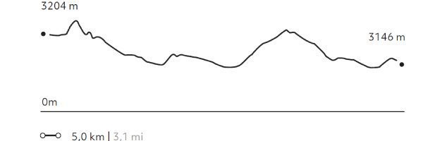
We take a van to the Domeyko Mountain Range where we walk following a creek that used to be a route for gathering and bartering caravans. The walk ends at the Rainbow Valley formed by huge multicolored walls of mineral-rich soils. We return by van.
204 m 669 ft
-263 m -863 ft
3.231 m 10.600 ft
3.134 m 10.282 ftElevation Profile
Wanaku
Quebradas Intermedias
-
Hike
-
Moderate
-
Full-day
We take a van to the Domeyko Mountain Range, where we walk through trails that were formerly used as transit and bartering routes...
More details >Wanaku
-
Exploration Path
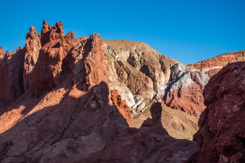
We take a van to the Domeyko Mountain Range, where we walk through trails that were formerly used as transit and bartering routes and where we can still see remains of the Atacameño culture. We continue to the Rainbow Valley, a place with huge multicolored walls that explain the geological shaping of the Atacama region.
410 m 1345 ft
-336 m -1102 ft
3.292 m 10.798 ft
3.198 m 10.489 ftElevation Profile
Incahuasi
Quebradas Intermedias
-
Hike
-
Advanced
-
Full-day
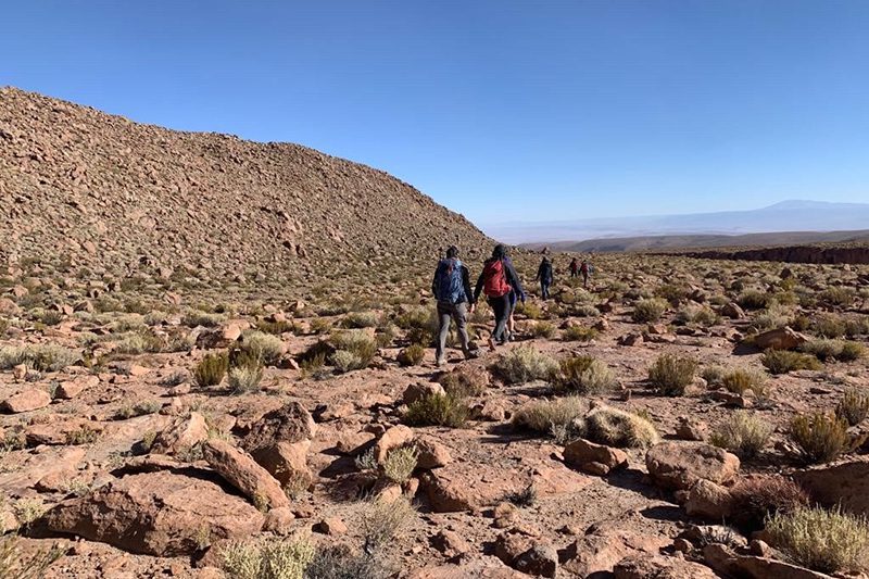
We start walking in an old farmhouse at the foot of the volcanoes of the Andes mountain range. We will enter the Jorquencal gorge...
More details >Incahuasi

-
Exploration Path
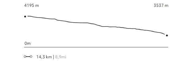
We start walking in an old farmhouse at the foot of the volcanoes of the Andes mountain range. We will enter the Jorquencal gorge where we will explore the varied vegetation, history and study of the Andean cat in the Puritama reserve. After crossing a varied landscape we will arrive at the Puritama hot springs, to rest there. Return by van to Explora.
181 m 594 ft
-832 m -2.730 ft
4.195 m 13.763 ft
3.537 m 11.604 ftElevation Profile
Peñaliri
Quebradas Intermedias
-
Hike
-
Moderate
-
Full-day
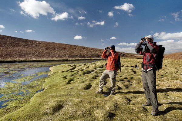
We take a van to Machuca, an Andean Plateau village. We begin exploring a wetland and then walk along a creek to the Grande River...
More details >Peñaliri
-
Exploration Path
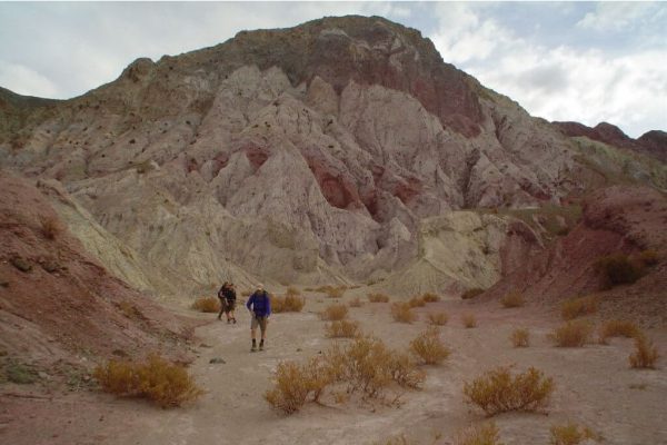
We take a van to Machuca, an Andean Plateau village. We begin exploring a wetland and then walk along a creek to the Grande River. In this exploration we can see fauna and typical Andean farming terraces. We have lunch at Peñaliri, an abandoned village.
*Temporarily unavailable. Consult other exploration options with your Explora guide at the destination.
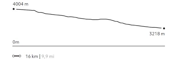
273 m 896 ft
-1.056 m -3.465 ft
4.012 m 13.163 ft
3.218 m 10.558 ftElevation Profile
Quebradas
Quebradas Intermedias
-
Overland
-
Easy
-
Half-day
We take a van to the Yerbas Buenas archaeological site located in the Domeyko Mountain Range. Here we can see...
More details >Quebradas
-
Exploration Path
We take a van to the Yerbas Buenas archaeological site located in the Domeyko Mountain Range. Here we can see different styles of petroglyphs.
We continue to the Rainbow Valley, where a special formation with varied shades of colors welcomes us to walk through the valley.
-
Other options: