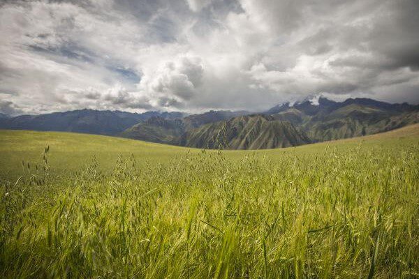
Sacred Valley
Sacred Valley of the Incas, Peru
Explorations in
Sacred Valley
Activity
Difficulty
Areas
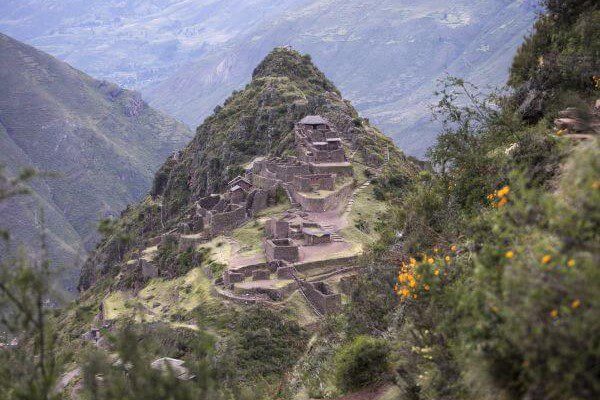
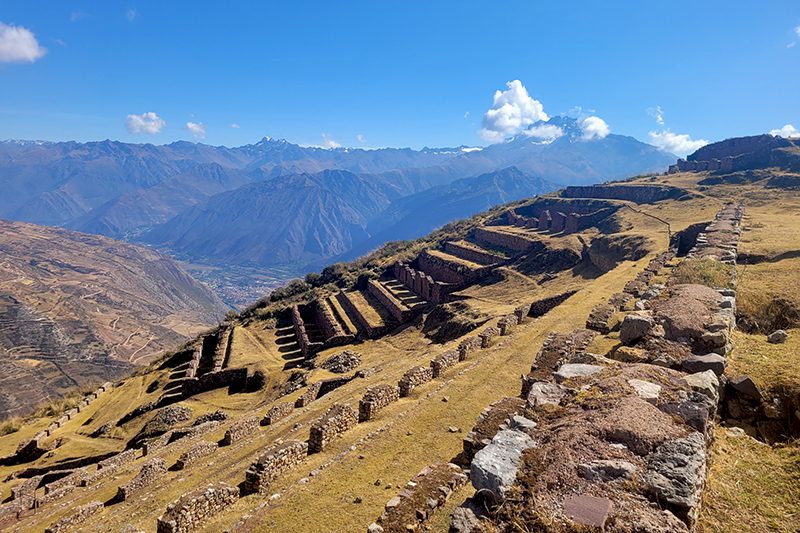
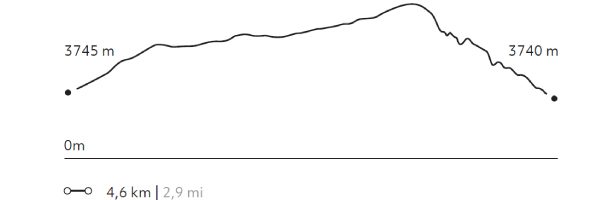
Senderito de Pisaq
Suni
-
 Hike
Hike -
Moderate
-
Full-day
We descend from the mountains to the remains of Pisaq. We will use one of our alternative routes to access the back of the remains...
More details >Senderito de Pisaq


-
Exploration Path
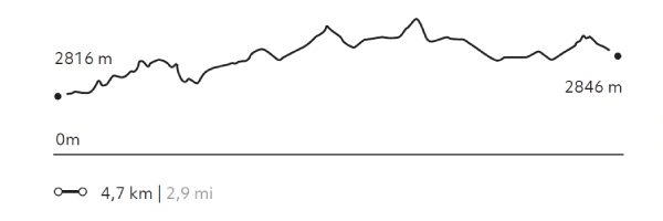
We descend from the mountains to the remains of Pisaq. We will use one of our alternative routes to access the back of the remains, which provides for a unique view. This exploration is recommended for every traveler wishing to enjoy an altitude landscape that calls for contemplation.
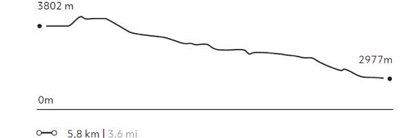
191 m 627 ft
-1.013 m -3.323 ft
3.871 m 12.700 ft
2.977 m 9.767 ftElevation Profile
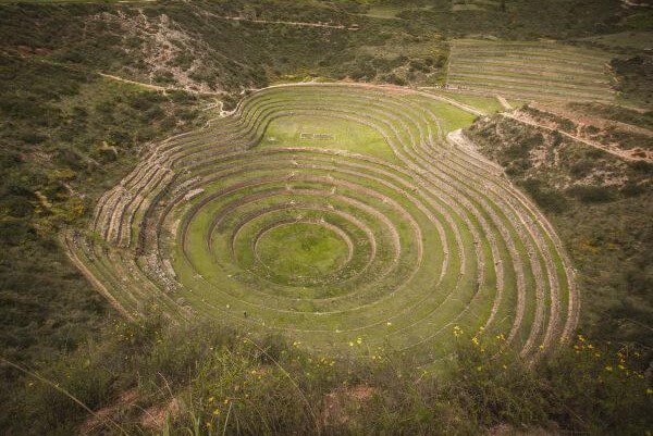
Moray
Suni
-
Hike
-
Easy
-
Half-day
The trail begins at a farming community located amidst hills and goes down to the Inca remains of Moray, a laboratory of experimental...
More details >Moray

-
Exploration Path
The trail begins at a farming community located amidst hills and goes down to the Inca remains of Moray, a laboratory of experimental farming where different microclimates are used to grow crops.
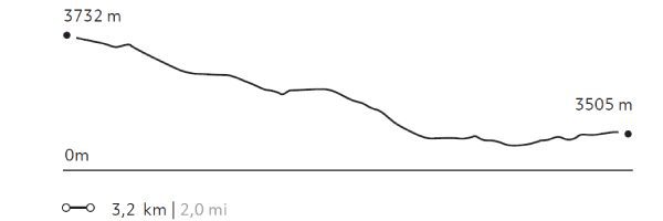
76 m 248 ft
-302 m -991 ft
3.732 m 12.244 ft
3.477 m 11.407 ftElevation Profile
Machu Kolka
Suni
-
Hike
-
Easy
-
Half-day
We leave by van to Chinchero, where we begin a steep ascent through crops with views of the pampa, the valley of Urquillos and the snowy...
More details >Machu Kolka
-
Exploration Path
We leave by van to Chinchero, where we begin a steep ascent through crops with views of the pampa, the valley of Urquillos and the snowy peaks that crown the mountains. We walk to the Machu Kolka archaeological center, formerly used as a product storage warehouse. We explore the place and enjoy a privileged view of the valley. We return to explora by van.
236 m 774 ft
-243 m -797 ft
3.933 m 12.904 ft
3.740 m 12.270 ftElevation Profile
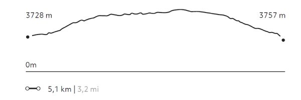
Kaytucha
Suni
-
Hike
-
Moderate
-
Half-day
We begin with a visit to the community of Cúper Bajo where we learn about textile techniques. Then we start our hike, ascending up...
More details >Kaytucha
-
Exploration Path
We begin with a visit to the community of Cúper Bajo where we learn about textile techniques. Then we start our hike, ascending up an agricultural road with panoramic views of lagoons, fields of crops and the town of Chinchero. Finally, we descend to the archaeological complex of Chinchero, where Inca and colonial elements merge. We return to explora by van.
270 m 886 ft
-241 m -791 ft
3.992 m 13.097 ft
3.728 m 12.231 ftElevation Profile
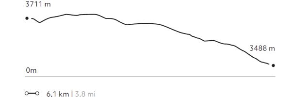
Racchi
Suni
-
Hike
-
Easy
-
Half-day
The walk carries you through orchards and communities to familiarize yourself with the rural landscape and its culture. This exploration takes...
More details >Racchi
-
Exploration Path
The walk carries you through orchards and communities to familiarize yourself with the rural landscape and its culture. This exploration takes place at a mean height and offers panoramic views to the Sacred Valley and its snowed capped peaks. It provides a good chance for acclimatization and to understand the area’s geography.
63 m 207 ft
-287 m -942 ft
3.733 m 12.247 ft
3.488 m 11.444 ftElevation Profile
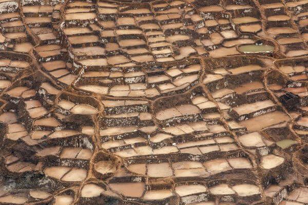
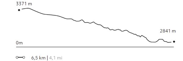
Salineras
Quechua
-
Hike
-
Moderate
-
Half-day
Hiking begins visiting the colonial town of Maras. After crossing the village, the trail descends among potato fields to the community’s salt...
More details >Salineras
-
Exploration Path
Hiking begins visiting the colonial town of Maras. After crossing the village, the trail descends among potato fields to the community’s salt mines.
Not recommended for travelers with fear of heights.
162 m 531 ft
-681 m -2.234 ft
3.371 m 11.060 ft
2.841 m 9.321 ftElevation Profile
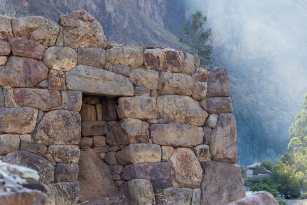
Ollantaytambo
Quechua
-
Hike
-
Easy
-
Half-day
The walk takes us through the living Inca town of Ollantaytambo. The trail passes through the old main gate and over cobblestone streets...
More details >Ollantaytambo
-
Exploration Path
The walk takes us through the living Inca town of Ollantaytambo. The trail passes through the old main gate and over cobblestone streets framed by narrow water channels. After visiting the village, we climb to the archaeological site to see its terraces, the ceremonial center and the Royal Building.
177 m 581 ft
-146 m -479 ft
2.885 m 9.465 ft
2.816 m 9.239 ftElevation Profile
Huertos de Yucay
Quechua
-
Hike
-
Easy
-
Half-day
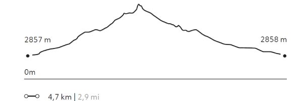
The exploration begins at Yucay, the former residence of the prominent Inca rulers Tupac Inca Yupanqui, Huaynacapac and Sayritupac...
More details >Huertos de Yucay
-
Exploration Path
The exploration begins at Yucay, the former residence of the prominent Inca rulers Tupac Inca Yupanqui, Huaynacapac and Sayritupac, and abundant crop fields. The trail takes you to the area’s platforms and crop fields.
224 m 735 ft
-224 m -735 ft
3.051 m 10.010 ft
2.857 m 9.373 ftElevation Profile
-
Other options: