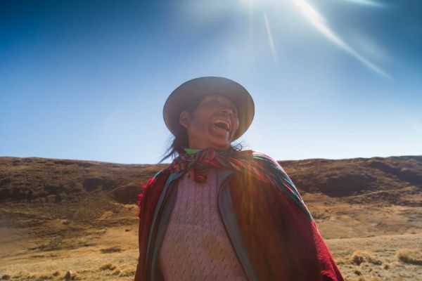
Sacred Valley
Sacred Valley of the Incas, Peru
Explorations in
Sacred Valley
Activity
Difficulty
Areas
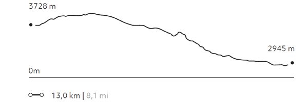
Full Day Inca Trail
Quechua
-
 Hike
Hike -
Moderate
-
Full-day
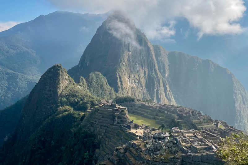
Embark on an unforgettable trekking exploration along one of the world's most iconic trails. Follow in the footsteps of the ancient Incas on the famous Qhapaq Ñan, the royal road network of the Inca Empire, as you trek on foot to the legendary Machu Picchu.
More details >Full Day Inca Trail


-
Exploration Path
Embark on an unforgettable trekking exploration along one of the world's most iconic trails. Follow in the footsteps of the ancient Incas on the famous Qhapaq Ñan, the royal road network of the Inca Empire, as you trek on foot to the legendary Machu Picchu.
Starting with a scenic train ride to the trailhead, the journey unfolds through lush cloud forests, over ancient stone steps and through timeless mountain tunnels, culminating in an awe-inspiring arrival at the Sun Gate (Inti Punku) - the grand entrance to the legendary Machu Picchu, just as the Incas experienced it centuries ago.
*Exploration coordinated with services provided by third parties (Subject to availability). Additional cost of USD $1,980 per couple (If only one person attends, the cost remains the same; if more than two people are attending, each additional person pays USD $990).
We recommend booking this exploration with anticipation directly through us at reserve@explora.com.
861 m 2825 ft
-587 m -1926 ft
2.713 m 8.901 ft
2.169 m 7.116 ftElevation Profile
Yanahuara
Quechua
-
Hike
-
Easy
-
Half-day
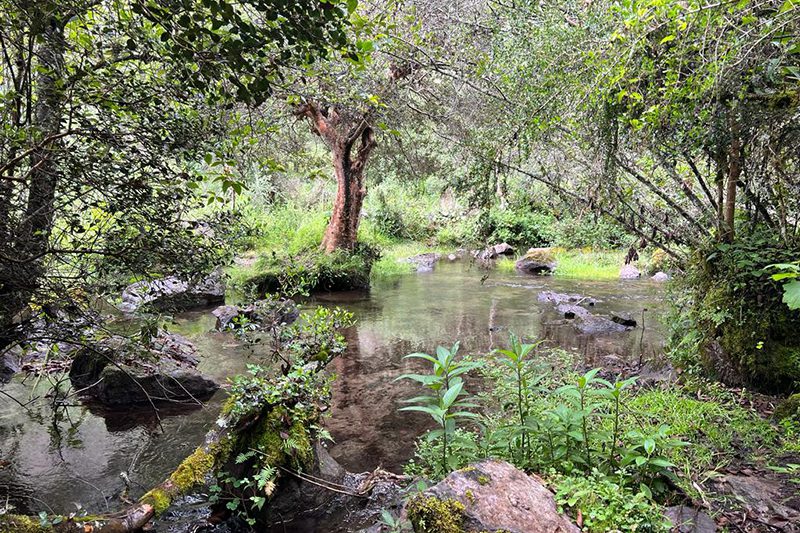
Inside Quebrada Yanahuara, following a small stream that descends from the glaciers and crosses an ancient forest, we will find tremendous biodiversity with native trees over 200 years old. After leaving the gorge we will visit Enisfera, a private reserve that preserves hummingbirds, where we will observe these beautiful birds, which are characteristic of the valley.
More details >Yanahuara

-
Exploration Path
Inside Quebrada Yanahuara, following a small stream that descends from the glaciers and crosses an ancient forest, we will find tremendous biodiversity with native trees over 200 years old. After leaving the gorge we will visit Enisfera, a private reserve that preserves hummingbirds, where we will observe these beautiful birds, which are characteristic of the valley.
244 m 801 ft
-244 m -801 ft
3.357 m 11.014 ft
3.197 m 10.489 ftElevation Profile
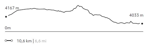
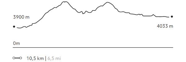
Parcco
Puna
-
Hike
-
Advanced
-
Half-day
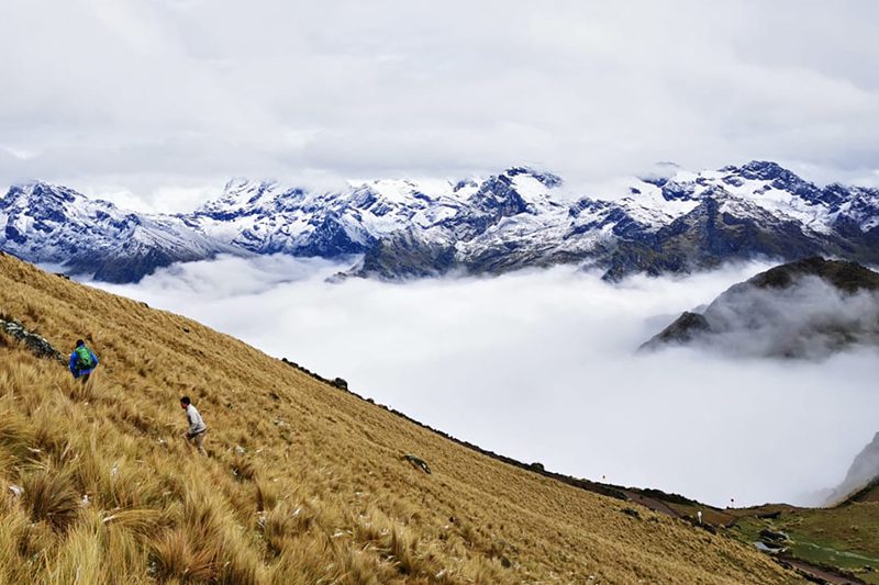
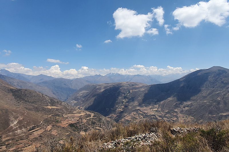
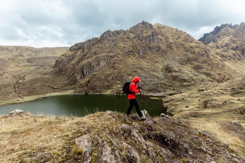
On this occasion we will be behind the massif of Pitusiray, the apu or mountain lord of Calca province, and walk along the edge of a mountain range where we will have the chance to see different lagoons and the slopes of Quebrada Calca and Quebrada Lamay, along with folds of the earth's crust that add drama to Andean geology.
More details >Parcco

-
Exploration Path
On this occasion we will be behind the massif of Pitusiray, the apu or mountain lord of Calca province, and walk along the edge of a mountain range where we will have the chance to see different lagoons and the slopes of Quebrada Calca and Quebrada Lamay, along with folds of the earth's crust that add drama to Andean geology.
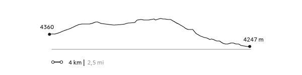
275 m 902 ft
-376 m -1.234 ft
4.526 m 14.849 ft
4.247 m 13.934 ftElevation Profile
Wata
Suni
-
Hike
-
Moderate
-
Full-day
Following an old Inca road still used by the region's inhabitants to trade products between Pampa de Anta and the Sacred Valley, we go into the ravine until we reach Wata, an old ceremonial center on the mountain peak that predates the Incan era and has spectacular views of the mountain range and the Quebrada Huarocondo.
More details >Wata
-
Exploration Path
Following an old Inca road still used by the region's inhabitants to trade products between Pampa de Anta and the Sacred Valley, we go into the ravine until we reach Wata, an old ceremonial center on the mountain peak that predates the Incan era and has spectacular views of the mountain range and the Quebrada Huarocondo.
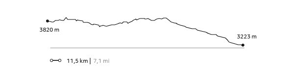
808 m 2.651 ft
-1.235 m -4.052 ft
3.820 m 12.533 ft
3.223 m 10.574 ftElevation Profile
La Verónica
Puna
-
Hike
-
Moderate
-
Full-day
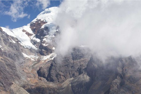
This hiking takes us through a reserve aimed at preserving forests and endangered birds. In the dry season, the snow-capped Verónica...
More details >La Verónica
-
Exploration Path
This hiking takes us through a reserve aimed at preserving forests and endangered birds. In the dry season, the snow-capped Verónica hill and the mountains surrounding it are the main attractions. During the rainy season, views may be obstructed by clouds, but then the ground steals the limelight.
164 m 538 ft
-680 m -2.231 ft
4.418 m 14.495 ft
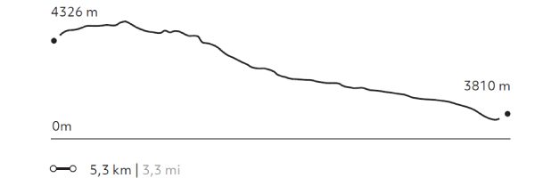
3.810 m 12.500 ftElevation Profile
Pachatusan
Puna
-
Hike
-
Expert
-
Full-day
We begin our ascent by a path of agricultural and livestock use. During this exploration, we can see Cerro Pachatusan, considered in Inca culture...
More details >Pachatusan

-
Exploration Path
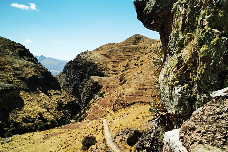
We begin our ascent by a path of agricultural and livestock use. During this exploration, we can see Cerro Pachatusan, considered in Inca culture to be the protector of the world. We walk to an open area with wide views of the Cusco Valley and finally, we descend to the archaeological centers of Pukara and Tipón, where agriculture was developed with an important Inca hydraulic system that is still in use today.
1.344 m 4.409 ft
-991 m -3.251 ft
4.179 m 13.711 ft
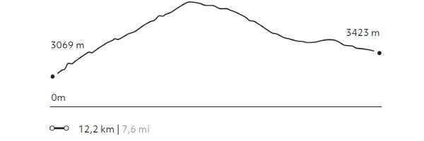
3.069 m 10.069 ftElevation Profile
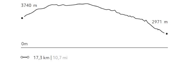
Huchuy Qosqo
Puna
-
Hike
-
Advanced
-
Full-day
This exploration offers breathtaking views to lagoons at different altitudes, to the farmlands of Chinchero and to the valleys. To reach...
More details >Huchuy Qosqo
-
Exploration Path
This exploration offers breathtaking views to lagoons at different altitudes, to the farmlands of Chinchero and to the valleys. To reach the remains of the Huchuy Qosqo Palaces, it goes down an Inca trail. Once in the remains, you cannot miss lying down in the gardens, taking a rest and enjoying the view towards Sacred Valley.
968 m 3.176 ft
-1.738 m -5.702 ft
4.318 m 14.167 ft
2.971 m 9.747 ftElevation Profile
Stream to Cusco
Puna

-
Hike
-
Advanced
-
Full-day
The trail crosses the mountains that separate the Sacred Valley from Cusco and reaches the Town Square of the Inca’s imperial city. This road...
More details >Stream to Cusco
-
Exploration Path
The trail crosses the mountains that separate the Sacred Valley from Cusco and reaches the Town Square of the Inca’s imperial city. This road simulates the journey followed by the Incas and Spanish conquerors more than 500 years ago. Before completing the exploration, there is a guided tour to the huge walls of the Saqsaywaman and its archaeological and ceremonial centers.
630 m 2.067 ft
-968 m -3.176 ft
4.281 m 14.045 ft
3.402 m 11.161 ftElevation Profile
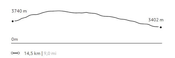
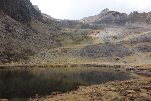
Tastayoc
Puna
-
Hike
-
Advanced
-
Full-day
We begin in the altitude, through a pastureland highly isolated from the rest of the valley. The trail includes several lagoons...
More details >Tastayoc
-
Exploration Path
We begin in the altitude, through a pastureland highly isolated from the rest of the valley. The trail includes several lagoons, some with turquoise waters due to thawing, and others with transparent waters, allowing travelers to learn about high-mountain water ecosystems.
892 m 2.927 ft
-1.085 m -3.560 ft
4.687 m 15.377 ft
3.786 m 12.421 ftElevation Profile
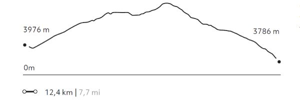
Lloclla
Puna
-
Hike
-
Moderate
-
Full-day
This mountain walk follows tracks used by local shepherds among lagoons serving as water deposits to sustain the area’s rural lifestyle...
More details >Lloclla
-
Exploration Path
This mountain walk follows tracks used by local shepherds among lagoons serving as water deposits to sustain the area’s rural lifestyle between the valleys of Lamay and Pisac. Old mountain trails, mild slopes, views, and people, among others, invite travelers to relax, walk calmly, breathe deeply and enjoy different perspectives and colors.
432 m 1.417 ft
-583 m -1.913 ft
4.396 m 14.423 ft
4.033 m 13.232 ftElevation Profile
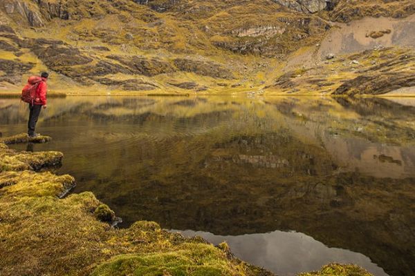
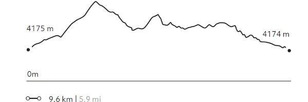
5 Lagunas
Puna
-
Hike
-
Moderate
-
Full-day
This walk begins at an isolated community in the heights of the Andes. From there, the trail goes up to a broad pass from...
More details >5 Lagunas
-
Exploration Path
This walk begins at an isolated community in the heights of the Andes. From there, the trail goes up to a broad pass from where to observe the snow capped Sawasiray and other snowcapped peaks. The descent takes us through a ravine with llama and alpaca herds, passing beside several lagoons that reflect the large snowcapped peak in the background and the yellow-colored mountains.
432 m 1.417 ft
-435 m -1.427 ft
4.357 m 14.295 ft
4.174 m 13.694 ftElevation Profile
Paru
Puna
-
Hike
-
Moderate
-
Full-day
This exploration transports travelers to paths where only shepherds pass. There they will walk to more than 13000 ft. Then, following some water...
More details >Paru
-
Exploration Path
This exploration transports travelers to paths where only shepherds pass. There they will walk to more than 13000 ft. Then, following some water courses, explore the slopes of the mountains and lagoons between ranches of Paru-Paru.
716 m 2.349 ft
-582 m -1.909 ft
4.347 m 14.262 ft
3.900 m 12.795 ftElevation Profile
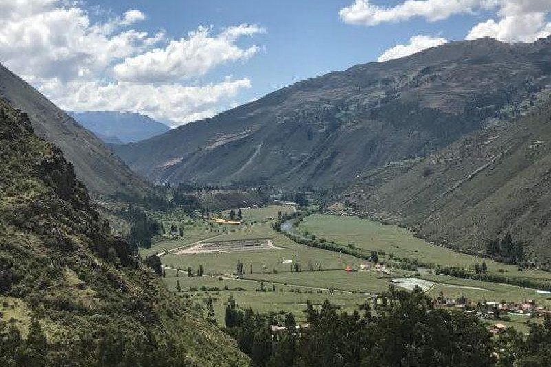
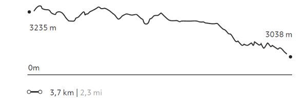
Arin
Quechua
-
Hike
-
Easy
-
Half-day
Our hike begins in Huarán, on a narrow path that runs along an irrigation channel and different crops, with views of the valley and its ravines...
More details >Arin
-
Exploration Path
Our hike begins in Huarán, on a narrow path that runs along an irrigation channel and different crops, with views of the valley and its ravines; among them, that of Urquillos. We continue skirting the channel through forests of eucalyptus and smallholdings, until we come to a path by which we descend. Finally, we reach the community of Arín. We return to Explora by van.
* Not recommended for travelers with fear of heights.
332 m 1.089 ft
-529 m -1.736 ft
3.253 m 10.673 ft
3.038 m 9.967 ftElevation Profile
Amor Violento
Suni
-
Hike
-
Moderate
-
Full-day
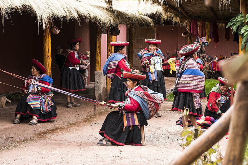
We begin with a visit to the community of Cúper Bajo, where a group of weavers teach us their work and culture. Next, we walk up the slope...
More details >Amor Violento
-
Exploration Path
We begin with a visit to the community of Cúper Bajo, where a group of weavers teach us their work and culture. Next, we walk up the slope of a large hill through agricultural terraces, the valley and the town of Chinchero. We descend to Chinchero and the archaeological site. From there, we take an Inca road down to the valley. We have lunch at a viewpoint and continue descending until we reach Explora.
590 m 1.936 ft
-1.387 m -4.551 ft
3.992 m 13.097 ft
2.945 m 9.662 ftElevation Profile
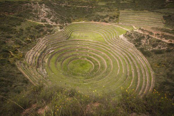
Maras Plateau
Suni
-
Hike
-
Moderate
-
Full-day
The trail begins at a farming community located amidst hills and goes down to the Inca remains of Moray, from where it continues to...
More details >Maras Plateau
-
Exploration Path
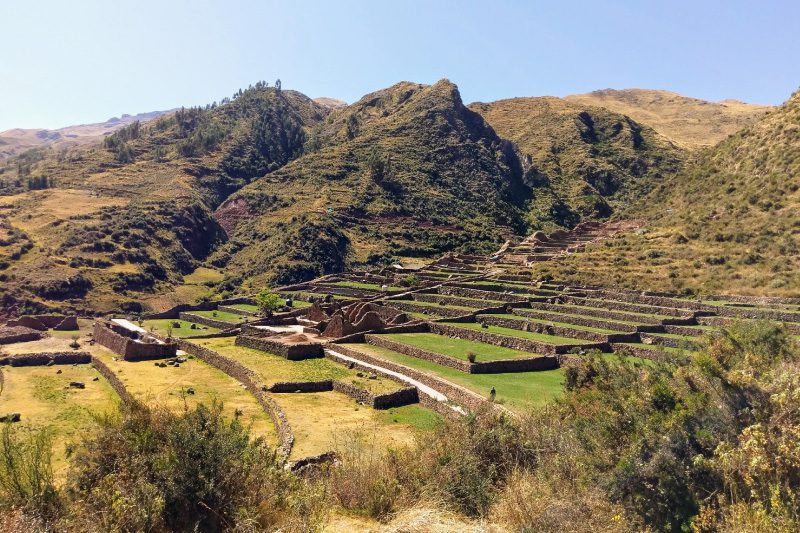
The trail begins at a farming community located amidst hills and goes down to the Inca remains of Moray, from where it continues to the colonial town of Maras. We see a piece of history in every corner. Afterwards, the trail descends to the bottom of the Sacred Valley and goes through the salt mines. The track crosses barley and potato fields and other crops.
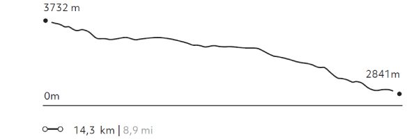
170 m 558 ft
-1.047 m -3.435 ft
3.732 m 12.244 ft
2.841 m 9.321 ftElevation Profile
-
Other options: