Torres del Paine
Patagonia, Chile
Explorations in
Torres del Paine
Activity
Difficulty
Areas
Puma Encounters
Estepa
-
 Overland
 -
Easy
-
Full-day
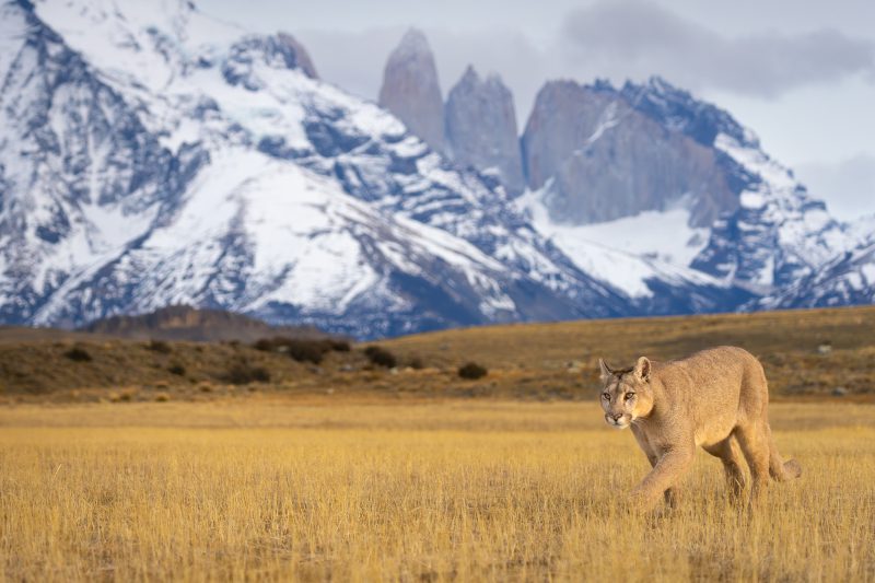
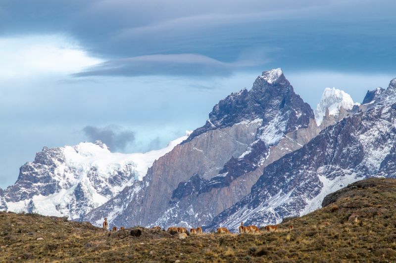
An exploration that invites you to responsibly observe pumas in their natural habitat. Accompanied by expert guides, you will explore the stunning landscapes of Patagonia and have the chance to observe this iconic feline.
We invite you to experience the thrill of venturing into puma territory.
This exploration is available exclusively for guests aged 18 and over.
*Exploration coordinated with services provided by third parties (subject to availability). Additional cost of USD 2,700 for a single traveler and USD 1,550 per person for groups of 2 to 6 travelers.
We recommend booking this exploration in advance directly through us at reserve@explora.com
More details >
Puma Encounters


-
Exploration Path
An exploration that invites you to responsibly observe pumas in their natural habitat. Accompanied by expert guides, you will explore the stunning landscapes of Patagonia and have the chance to observe this iconic feline.
We invite you to experience the thrill of venturing into puma territory.
This exploration is available exclusively for guests aged 18 and over.
*Exploration coordinated with services provided by third parties (subject to availability). Additional cost of USD 2,700 for a single traveler and USD 1,550 per person for groups of 2 to 6 travelers.
We recommend booking this exploration in advance directly through us at reserve@explora.com
Horizonte
Conservation Reserve
-
Hike
-
Moderate
-
Full-day
Discover one of the most scenic hikes in the Explora Torres del Paine Conservation Reserve. Explore lenga forests, sweeping views of the Paine Massif, and condor cliffs from the Obelisco Lookout.
More details >Horizonte


-
Exploration Path
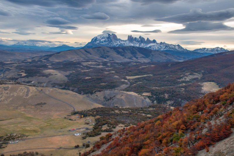
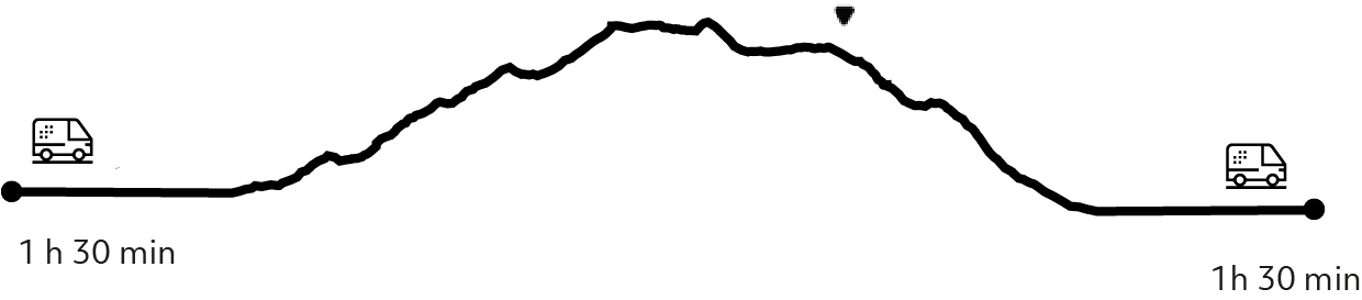
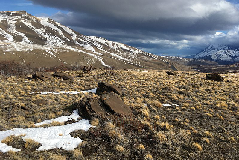
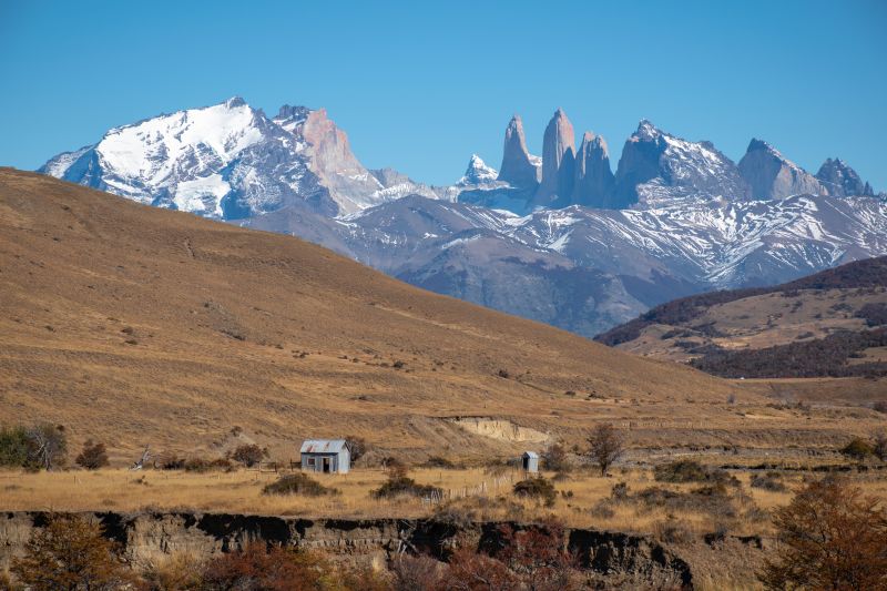
We drive to the Torres del Paine Conservation Reserve, located in the northeastern side of the national park. Our hike begins near the old estancia buildings, gradually ascending the slopes of the Obelisco hill and Punta Hermandad. The trail takes us from the Patagonian steppe through patches of shrubland and lenga forests, in an increasingly scenic setting.
As we gain elevation, panoramic views open to the south: wetlands, rivers, and vast steppe plains framed by the Paine Massif, with the iconic three Towers standing out in the distance. To the north, the towering rock walls of the Obelisco hill dominate the landscape, showcasing dramatic sediment layers and condor roosting sites. After taking in this monumental scenery, we begin our descent and return to the lodge by van.
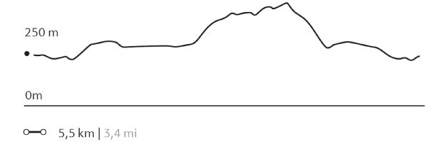
656 m 2152 ft
-686 m -2251 ft
928 m 3045 ft
1378 m 451 ftElevation Profile
Exploradores
Conservation Reserve
-
Hike
-
Moderate
-
Half-day
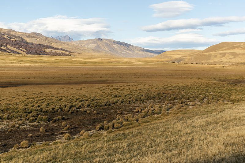
We hike across the steppe of the reserve, surrounded by mountains, steppe and valleys. Aloong the way, you will be able to enjoy views of the Paine range, Cerro Obelisco, Laguna Jara and Sierra Baguales. The local flora is rich in coirón, matabarrosa and ñirre, while the fauna includes guanacos, pumas, chingues, caranchyos, condors and flamingoes, among others. In this area you can see the history of the occupation of the province of Última Esperanza, due to the old estate that was here. You will also learn about the history of Lady Florence Dixie, the first woman explorer in Patagonia.
More details >Exploradores
-
Exploration Path
We hike across the steppe of the reserve, surrounded by mountains, steppe and valleys. Along the way, you will be able to enjoy views of the Paine range, Cerro Obelisco, Laguna Jara and Sierra Baguales. The local flora is rich in coirón, matabarrosa and ñirre, while the fauna includes guanacos, pumas, chingues, caranchyos, condors and flamingoes, among others.
In this area you can see the history of the occupation of the province of Última Esperanza, due to the old estate that was here. You will also learn about the history of Lady Florence Dixie, the first woman explorer in Patagonia.
El Pasado
Conservation Reserve

-
Hike
-
Easy
-
Half-day
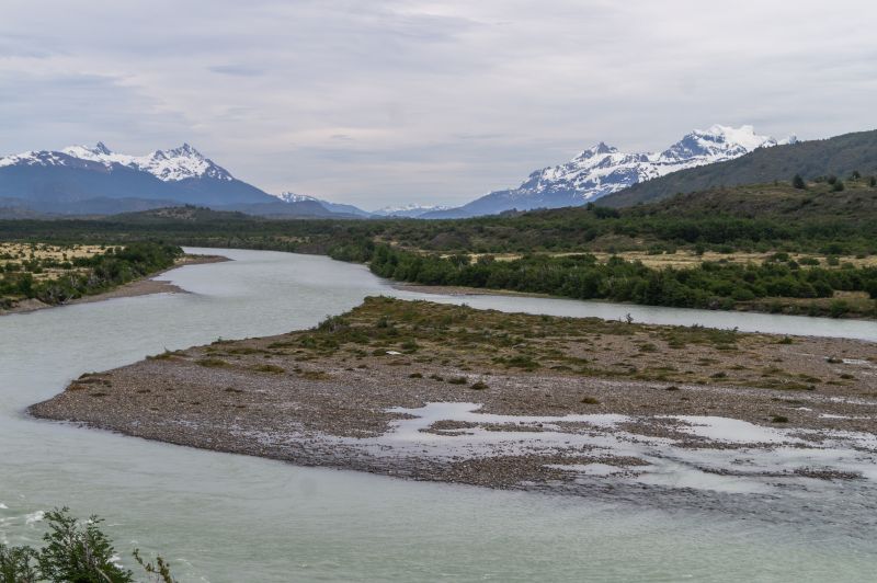
We walked through the western sector of the Torres del Paine Conservation Reserve, with views of the Zamora Canyon and river, passing through Magellanic forests and rock monoliths. Throughout the journey, one can admire views of the impressive "V"-shaped canyon of the Zamora River and the Paine mountain range, including the Obelisco Hill. The local flora is rich in coiron, matabarrosa, lenga, mataguanacos, and nirre, while the fauna includes guanacos, pumas, chingues, caranchos, condors, bandurria, chuncho, among others.
More details >El Pasado
-
Exploration Path
We walked through the western sector of the Torres del Paine Conservation Reserve, with views of the Zamora Canyon and river, passing through Magellanic forests and rock monoliths. Throughout the journey, one can admire views of the impressive "V"-shaped canyon of the Zamora River and the Paine mountain range, including the Obelisco Hill. The local flora is rich in coiron, matabarrosa, lenga, mataguanacos, and nirre, while the fauna includes guanacos, pumas, chingues, caranchos, condors, bandurria, chuncho, among others.
157 m 515 ft
-126 m -413 ft
489 m 1.604 ft
371 m 1.217 ftElevation Profile

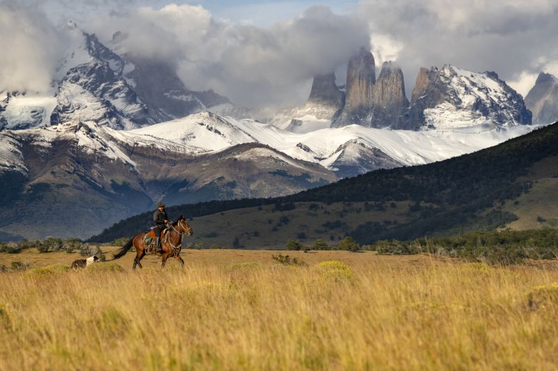
Fronteras
Conservation Reserve
-
Horseback Ride
-
Easy
-
Half-day
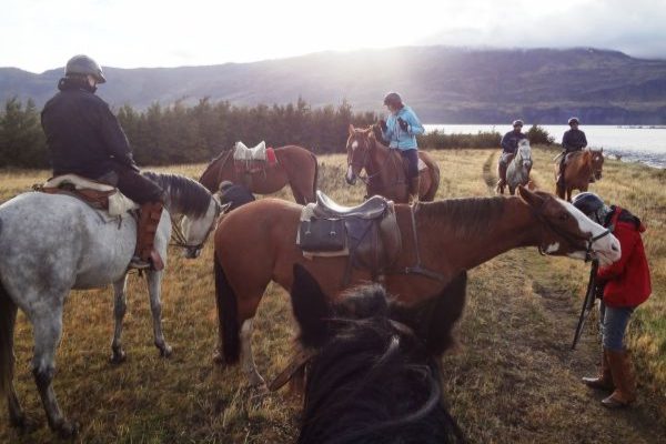
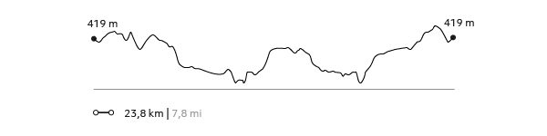
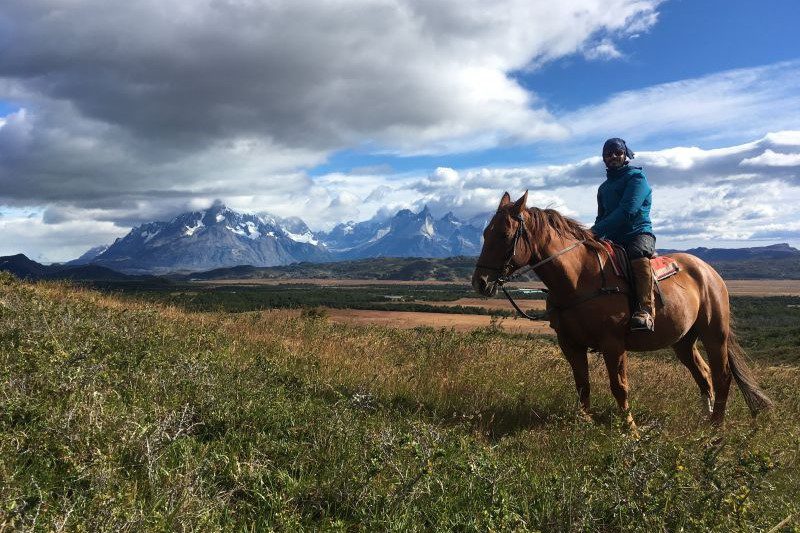
We leave the stables on horseback and ride toward Laguna Jara, where we will have a view of steppes, La Vega (wetland), ñirre forests and regenerative grazing areas.
More details >Fronteras

-
Exploration Path
We leave the stables on horseback and ride toward Laguna Jara, where we will have a view of steppes, La Vega (wetland), ñirre forests and regenerative grazing areas.
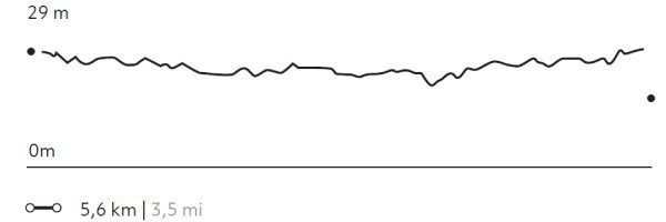
150 m 492 ft
-150 m -492 ft
477 m 1.565 ft
407 m 1.335 ftElevation Profile
AONIKENK
Estepa
-
Hike
-
Moderate
-
Half-day
We travel by van to the eastern sector of the park, where we hike, exploring the wildlife. During the walk, we visit a cave...
More details >AONIKENK
-
Exploration Path
We travel by van to the eastern sector of the park, where we hike, exploring the wildlife. During the walk, we visit a cave with paintings that are over 4,000 years old. We can observe the geese, ducks and swans in the lagoons that are on the way. The terrain has various ascents and descents without steep slopes. Return by van.
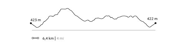
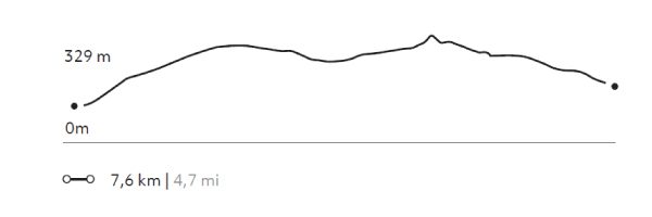
303 m 994 ft
-237 m -778 ft
329 m 1.079 ft
95 m 312 ftElevation Profile
Tough Life
Conservation Reserve
-
Horseback Ride
-
Advanced
-
Half-day
We leave the stables on horseback and ride across the steppe of the Torres del Paine Conservation Reserve, passing Laguna Jara before reaching the El Mercado outpost, an old shelter on the estate used by gauchos to protect the place and the cattle.
More details >Tough Life

-
Exploration Path
We leave the stables on horseback and ride across the steppe of the Torres del Paine Conservation Reserve, passing Laguna Jara before reaching the El Mercado outpost, an old shelter on the estate used by gauchos to protect the place and the cattle.
* Not recommended for travelers with fear of heights.
**For experienced and advanced riders only. This exploration is only available for advanced riders who have mastered rising trot and canter over uneven terrain in open spaces and on all types of horses. Advanced riders are physically fit and able to canter for long stretches without getting tired.
294 m 965 ft
-294 m -965 ft
414 m 1.358 ft
234 m 768 ftElevation Profile
PUNTILLA DEL TORO
Estepa
-
Horseback Ride
-
Easy
-
Half-day
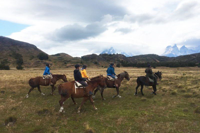
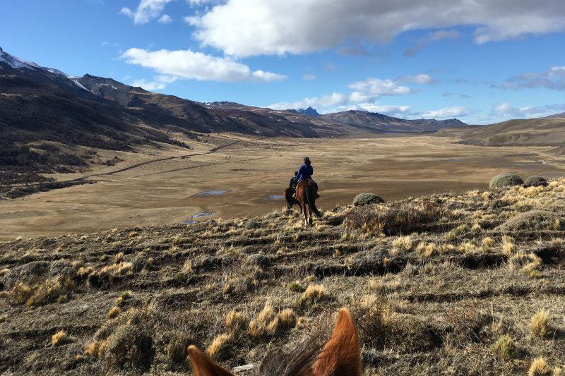
We leave the stables on horseback, riding across the Serrano pampa and passing lagoons with the Paine massif behind us. We will ride along the banks of the Serrano River and Lake Toro, which we will cross at different points. We will return via the pampa with views of the Paine massif.
More details >PUNTILLA DEL TORO
-
Exploration Path
We leave the stables on horseback, riding across the Serrano pampa and passing lagoons with the Paine massif behind us. We will ride along the banks of the Serrano River and Lake Toro, which we will cross at different points. We will return via the pampa with views of the Paine massif.
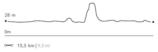
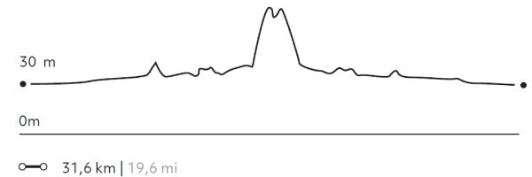
14 m 46 ft
-14 m -46 ft
30 m 98 ft
26 m 85 ftElevation Profile
Florence
Conservation Reserve
-
Horseback Ride
-
Advanced
-
Full-day
We leave the stables on horseback to visit different sectors of the Torres del Paine Conservation Reserve. We will pass the Santa Gemita outpost, a cultural vestige of the Patagonian estates.
More details >Florence
-
Exploration Path
We leave the stables on horseback to visit different sectors of the Torres del Paine Conservation Reserve. We will pass the Santa Gemita outpost, a cultural vestige of the Patagonian estates.
* Not recommended for travelers with fear of heights.
** For experienced and advanced riders only. This exploration is only available for advanced riders who have mastered rising trot and canter over uneven terrain in open spaces and on all types of horses. Advanced riders are physically fit and able to canter for long stretches without getting tired.
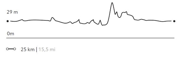
735 m 2.411 ft
-735 m -2.411 ft
477 m 1.565 ft
237 m 778 ftElevation Profile
SERRANO
Estepa
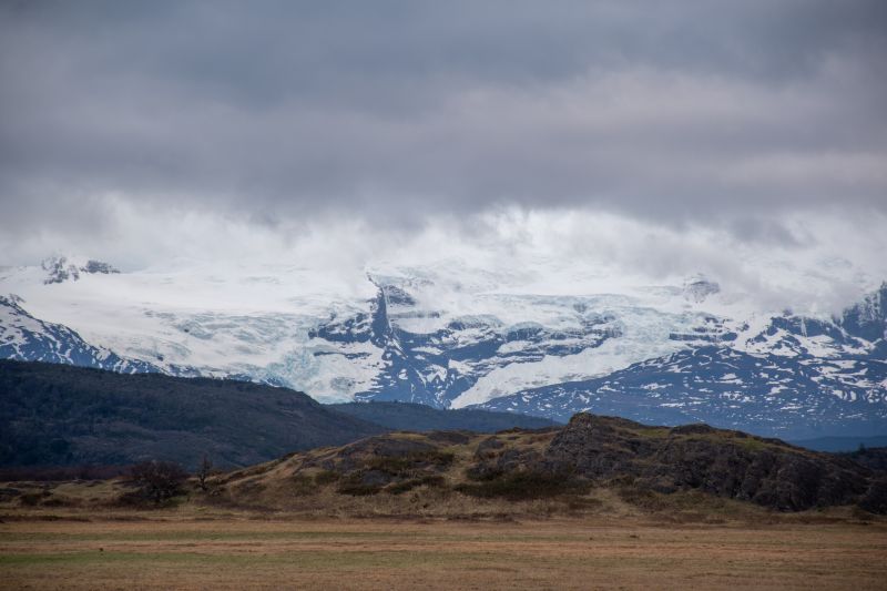
-
Horseback Ride
-
Advanced
-
Half-day
We depart from the stables riding on a plain along the Serrano River. Then, we cross some paths to a viewpoint...
More details >SERRANO
-
Exploration Path
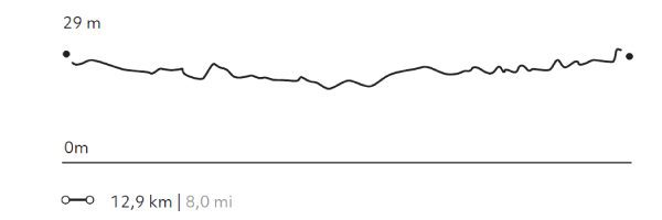
We depart from the stables riding on a plain along the Serrano River. Then, we cross some paths to a viewpoint from where we see a village on the outskirts of the park and the immensity of the plain that surrounds us. On the way back, we cross a small forest.
* For experienced and advanced riders only. This exploration is only available for advanced riders who have mastered rising trot and canter over uneven terrain in open spaces and on all types of horses. Advanced riders are physically fit and able to canter for long stretches without getting tired.
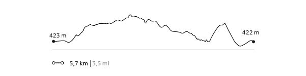
31 m 102 ft
-31 m -102 ft
30 m 98 ft
28 m 92 ftElevation Profile
DONOSITO
Encuentro
-
Horseback Ride
-
Advanced
-
Half-day
We depart from the stables riding through the Serrano pampas, cross the Grey bridge and ride along the river bank...
More details >DONOSITO
-
Exploration Path
We depart from the stables riding through the Serrano pampas, cross the Grey bridge and ride along the river bank. From there, we ascend a hill with dense vegetation. We pass through wetlands until we reach the Donosito viewpoint with views of the Serrano and Grey rivers, the plain and the Paine massif.
* For experienced and advanced riders only. This exploration is only available for advanced riders who have mastered rising trot and canter over uneven terrain in open spaces and on all types of horses. Advanced riders are physically fit and able to canter for long stretches without getting tired.
143 m 469 ft
-143 m -469 ft
101 m 331 ft
28 m 92 ftElevation Profile
DONOSO
Encuentro
-
Horseback Ride
-
Advanced
-
Full-day
We depart from the stables riding through the Pampa Serrano. We cross the Grey River and climb a hill crossing streams...
More details >DONOSO
-
Exploration Path
We depart from the stables riding through the Pampa Serrano. We cross the Grey River and climb a hill crossing streams, lagoons, plains and wetlands to the Donosito overlook with views of rivers, the Pampas and the Paine massif. We ascend up a narrow and pronounced path between trees to the Choros Lagoon. After lunch in the forest, we return to the stables.
* For experienced and advanced riders only. This exploration is only available for advanced riders who have mastered rising trot and canter over uneven terrain in open spaces and on all types of horses. Advanced riders are physically fit and able to canter for long stretches without getting tired.
260 m 853 ft
-260 m -853 ft
87 m 285 ft
14 m 46 ftElevation Profile
TÉMPANOS
Encuentro
-
Horseback Ride
-
Advanced
-
Full-day
We depart from the stables, galloping through plains and rocky terrain until we reach the banks of the Grey River...
More details >TÉMPANOS
-
Exploration Path
We depart from the stables, galloping through plains and rocky terrain until we reach the banks of the Grey River. We continue towards a hill, up a steep slope to the Témpanos viewpoint, from where we can see Grey Lake, its ice fields and the glacier in the distance.
* For experienced and advanced riders only. This exploration is only available for advanced riders who have mastered rising trot and canter over uneven terrain in open spaces and on all types of horses. Advanced riders are physically fit and able to canter for long stretches without getting tired.
505 m 1.657 ft
-505 m -1.657 ft
217 m 712 ft
28 m 92 ftElevation Profile
2 DE ENERO
Conservation Reserve
-
Horseback Ride
-
Expert
-
Half-day
We leave the stables on horseback and ride toward the forest sector of the Torres del Paine Conservation Reserve. Different Patagonian landscapes can be seen, such as the steppe, forests, La Vega (wetland) and the Zamora Valley, in addition to diverse wildlife like guanacos, pumas, condors, caranchos and bandurrias.
More details >2 DE ENERO

-
Exploration Path
We leave the stables on horseback and ride toward the forest sector of the Torres del Paine Conservation Reserve. Different Patagonian landscapes can be seen, such as the steppe, forests, La Vega (wetland) and the Zamora Valley, in addition to diverse wildlife like guanacos, pumas, condors, caranchos and bandurrias.
* For experienced and advanced riders only. This exploration is only available for advanced riders who have mastered rising trot and canter over uneven terrain in open spaces and on all types of horses. Advanced riders are physically fit and able to canter for long stretches without getting tired.
375 m 1230 ft
-375 m -1230 ft
475 m 1.558 ft
235 m 771 ftElevation Profile
Pioneros
Estepa
-
Overland
-
Easy
-
Half-day
We will visit the south-west area of the park, making various stops and short walks that will allow us to discover important landmarks...
More details >Pioneros
-
Exploration Path
We will visit the south-west area of the park, making various stops and short walks that will allow us to discover important landmarks in the history of Patagonia and the national park. We will cross various ecosystems associated with higher humidity, such as the banks of the Serrano River or the Lenga and Ñirre forests. We will have the opportunity to see various types of waterfowl, while we make stops to observe the lake and Gray Glacier, share a tea and enjoy one of the best views of the Paine massif.
-
Other options: