Sacred Valley
Sacred Valley of the Incas, Peru
Explorations in
Sacred Valley
Activity
Difficulty
Areas
9 Apus
Suni
-
 E-Bike
 -
Advanced
-
Half-day
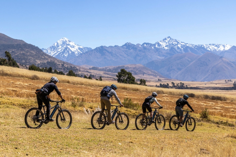
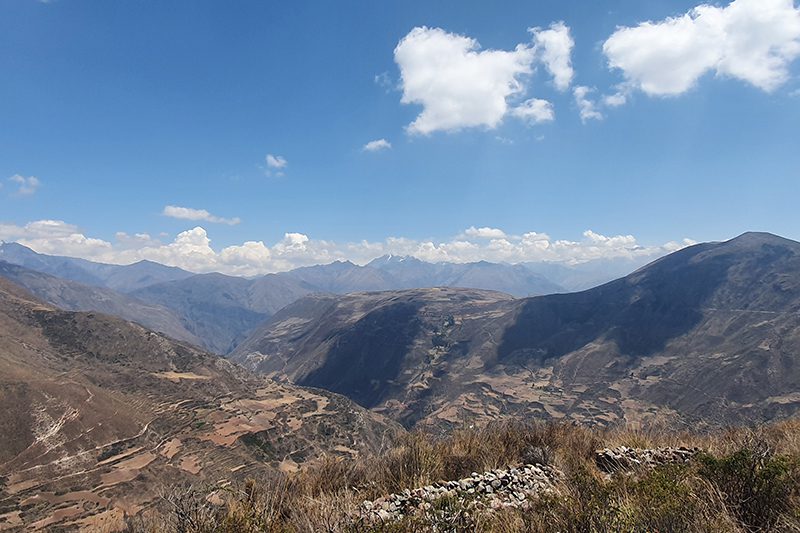
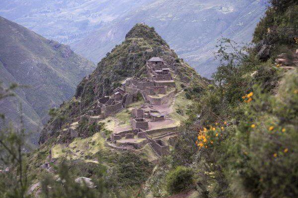
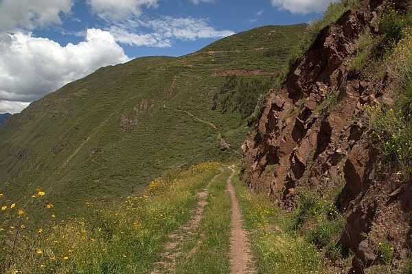
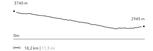
A Signature Explora ride for experienced mountain bikers seeking a technical route beyond the Sacred Valley. Follow ancient trails alongside the majestic Apus, sacred mountains long revered in Andean tradition. Veronica, the first of nine visible peaks, rises above quiet farmlands and village life. The route descends through Moray’s circular terraces and continues to Maras, where salt pools shimmer across the mountainside. A journey through ancestral landscapes and living tradition.
More details >9 Apus


-
Exploration Path
A Signature Explora ride for experienced mountain bikers seeking a technical route beyond the Sacred Valley. Follow ancient trails alongside the majestic Apus, sacred mountains long revered in Andean tradition. Veronica, the first of nine visible peaks, rises above quiet farmlands and village life. The route descends through Moray’s circular terraces and continues to Maras, where salt pools shimmer across the mountainside. A journey through ancestral landscapes and living tradition.
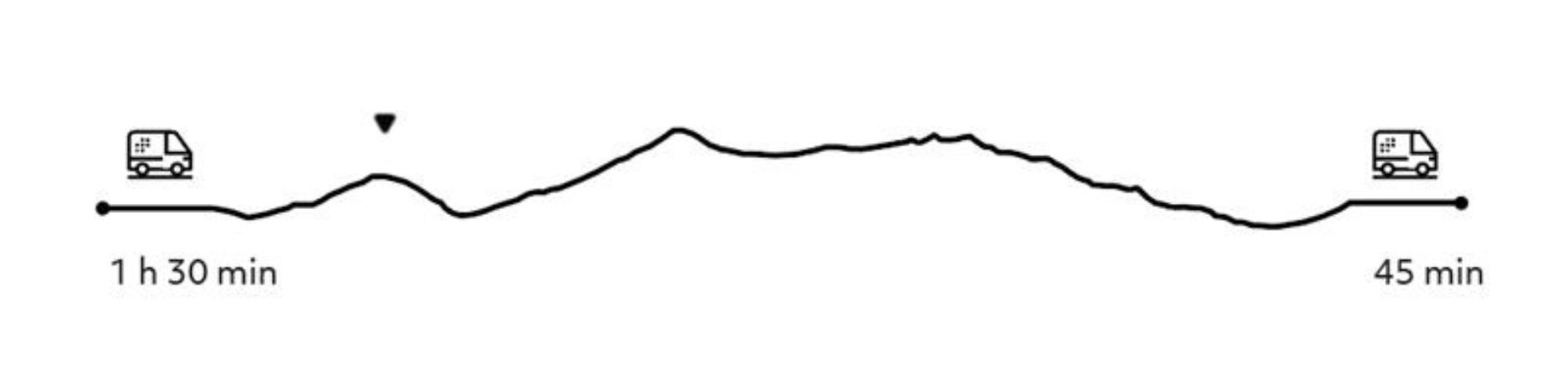
1534 m 5033 ft
1497 m 4911 ft
3772 m 12.375 ft
3280 m 10.761 ftElevation Profile
Wiraqocha
Suni
-
E-Bike
-
Easy
-
Full-day
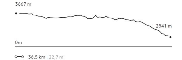
Beyond the Sacred Valley, an ancient route winds through quinoa fields and eucalyptus forests, revealing a landscape where history and tradition remain alive. This e-bike journey leads to the vast agricultural terraces of Zurite, among the largest built by the Inca. Along the way, discover the colonial village of Tiobamba and its 16th-century church, where Andean artistry blends with baroque design, and take in views of the glistening salt pools of Maras, carved into the mountainside.
More details >Wiraqocha

-
Exploration Path
Beyond the Sacred Valley, an ancient route winds through quinoa fields and eucalyptus forests, revealing a landscape where history and tradition remain alive. This e-bike journey leads to the vast agricultural terraces of Zurite, among the largest built by the Inca. Along the way, discover the colonial village of Tiobamba and its 16th-century church, where Andean artistry blends with baroque design, and take in views of the glistening salt pools of Maras, carved into the mountainside.
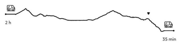
1393 m 4570 ft
2136 m 7008 ft
3831 m 12569 ft
2844 m 9331 ftElevation Profile
Wata
Suni
-
Hike
-
Moderate
-
Full-day
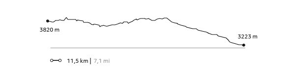
Following an old Inca road still used by the region's inhabitants to trade products between Pampa de Anta and the Sacred Valley, we go into the ravine until we reach Wata, an old ceremonial center on the mountain peak that predates the Incan era and has spectacular views of the mountain range and the Quebrada Huarocondo.
More details >Wata


-
Exploration Path
Following an old Inca road still used by the region's inhabitants to trade products between Pampa de Anta and the Sacred Valley, we go into the ravine until we reach Wata, an old ceremonial center on the mountain peak that predates the Incan era and has spectacular views of the mountain range and the Quebrada Huarocondo.
808 m 2.651 ft
-1.235 m -4.052 ft
3.820 m 12.533 ft
3.223 m 10.574 ftElevation Profile
Racchi
Suni
-
Hike
-
Easy
-
Half-day
The walk carries you through orchards and communities to familiarize yourself with the rural landscape and its culture. This exploration takes...
More details >Racchi
-
Exploration Path
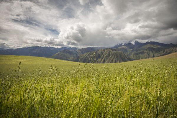
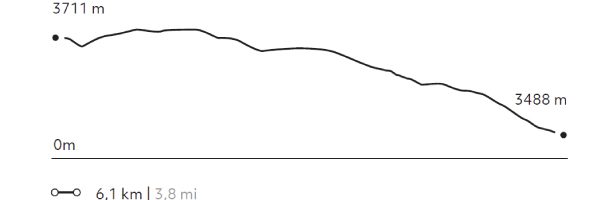
The walk carries you through orchards and communities to familiarize yourself with the rural landscape and its culture. This exploration takes place at a mean height and offers panoramic views to the Sacred Valley and its snowed capped peaks. It provides a good chance for acclimatization and to understand the area’s geography.
63 m 207 ft
-287 m -942 ft
3.733 m 12.247 ft
3.488 m 11.444 ftElevation Profile
Kaytucha
Suni
-
Hike
-
Moderate
-
Half-day
We begin with a visit to the community of Cúper Bajo where we learn about textile techniques. Then we start our hike, ascending up...
More details >Kaytucha
-
Exploration Path
We begin with a visit to the community of Cúper Bajo where we learn about textile techniques. Then we start our hike, ascending up an agricultural road with panoramic views of lagoons, fields of crops and the town of Chinchero. Finally, we descend to the archaeological complex of Chinchero, where Inca and colonial elements merge. We return to explora by van.
270 m 886 ft
-241 m -791 ft
3.992 m 13.097 ft
3.728 m 12.231 ftElevation Profile
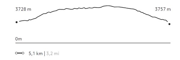
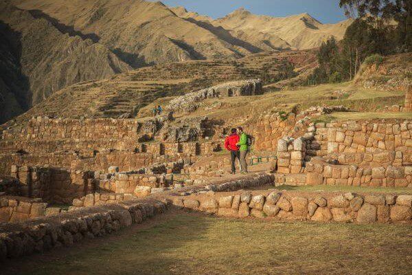
Machu Kolka
Suni
-
Hike
-
Easy
-
Half-day
We leave by van to Chinchero, where we begin a steep ascent through crops with views of the pampa, the valley of Urquillos and the snowy...
More details >Machu Kolka
-
Exploration Path
We leave by van to Chinchero, where we begin a steep ascent through crops with views of the pampa, the valley of Urquillos and the snowy peaks that crown the mountains. We walk to the Machu Kolka archaeological center, formerly used as a product storage warehouse. We explore the place and enjoy a privileged view of the valley. We return to explora by van.
236 m 774 ft
-243 m -797 ft
3.933 m 12.904 ft
3.740 m 12.270 ftElevation Profile
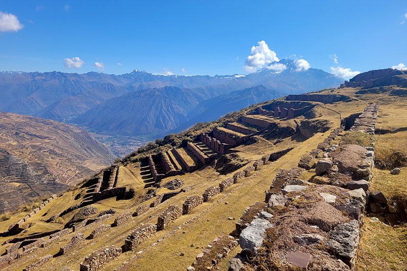
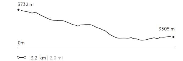
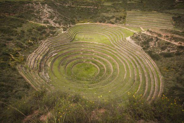
Moray
Suni

-
Hike
-
Easy
-
Half-day
The trail begins at a farming community located amidst hills and goes down to the Inca remains of Moray, a laboratory of experimental...
More details >Moray
-
Exploration Path
The trail begins at a farming community located amidst hills and goes down to the Inca remains of Moray, a laboratory of experimental farming where different microclimates are used to grow crops.
76 m 248 ft
-302 m -991 ft
3.732 m 12.244 ft
3.477 m 11.407 ftElevation Profile
Senderito de Pisaq
Suni
-
Hike
-
Moderate
-
Full-day
We descend from the mountains to the remains of Pisaq. We will use one of our alternative routes to access the back of the remains...
More details >Senderito de Pisaq
-
Exploration Path
We descend from the mountains to the remains of Pisaq. We will use one of our alternative routes to access the back of the remains, which provides for a unique view. This exploration is recommended for every traveler wishing to enjoy an altitude landscape that calls for contemplation.
191 m 627 ft
-1.013 m -3.323 ft
3.871 m 12.700 ft
2.977 m 9.767 ftElevation Profile
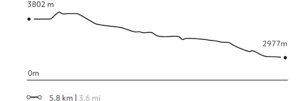
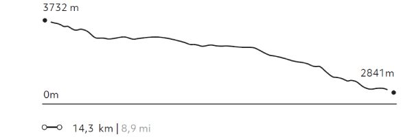
Maras Plateau
Suni
-
Hike
-
Moderate
-
Full-day
The trail begins at a farming community located amidst hills and goes down to the Inca remains of Moray, from where it continues to...
More details >Maras Plateau
-
Exploration Path
The trail begins at a farming community located amidst hills and goes down to the Inca remains of Moray, from where it continues to the colonial town of Maras. We see a piece of history in every corner. Afterwards, the trail descends to the bottom of the Sacred Valley and goes through the salt mines. The track crosses barley and potato fields and other crops.
170 m 558 ft
-1.047 m -3.435 ft
3.732 m 12.244 ft
2.841 m 9.321 ftElevation Profile
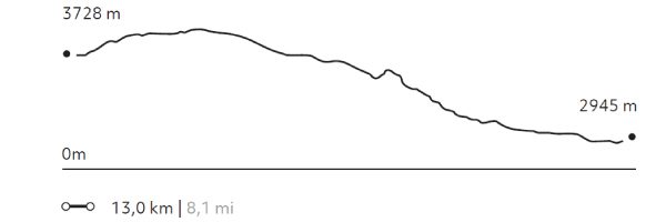
Amor Violento
Suni
-
Hike
-
Moderate
-
Full-day
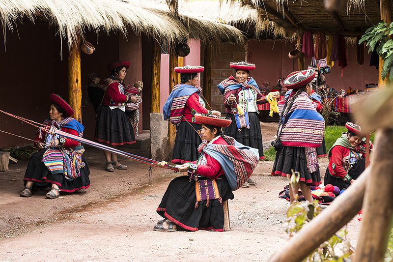
We begin with a visit to the community of Cúper Bajo, where a group of weavers teach us their work and culture. Next, we walk up the slope...
More details >Amor Violento
-
Exploration Path
We begin with a visit to the community of Cúper Bajo, where a group of weavers teach us their work and culture. Next, we walk up the slope of a large hill through agricultural terraces, the valley and the town of Chinchero. We descend to Chinchero and the archaeological site. From there, we take an Inca road down to the valley. We have lunch at a viewpoint and continue descending until we reach Explora.
590 m 1.936 ft
-1.387 m -4.551 ft
3.992 m 13.097 ft
2.945 m 9.662 ftElevation Profile
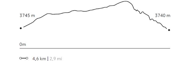
Huayna Kolka
Suni
-
Bike
-
Moderate
-
Half-day
After visiting the archaeological site of Machu Kolka, we get on our bikes and begin a descent among trees and adobe houses towards...
More details >Huayna Kolka
-
Exploration Path
After visiting the archaeological site of Machu Kolka, we get on our bikes and begin a descent among trees and adobe houses towards the town of Racchi. There, we pedal in ascent towards the viewpoint of Huayna Kolka to contemplate the valley. We descend by a winding dirt road to Huayllabamba. At this point, we skirt around different crop fields until we reach explora.
403 m 1.322 ft
-1.198 m -3.930 ft
3.740 m 12.270 ft
2.867 m 9.406 ftElevation Profile
Huaypo Views
Suni
-
Bike
-
Advanced
-
Full-day
This exploration crosses the farmlands of Chinchero, visiting small farms and villages. It takes the traveler...
More details >Huaypo Views
-
Exploration Path
This exploration crosses small farms and villages of Chinchero. It takes the traveler to the remains of the Moray experimental crop center, the colonial town of Maras and its Inca salt-mines, to finalize with a descent to the Urubamba River. This exploration is recommended for travelers in good physical conditions and experienced in mountain biking.
735 m 2.411 ft
-1.557 m -5.108 ft
3.710 m 12.172 ft
2.841 m 9.321 ftElevation Profile
Pirka
Suni
-
Overland
-
Easy
-
Full-day
This route first takes us to Ollantaytambo, also known as the “living Inca city”. From there we travel to the archaeological site of Moray...
More details >Pirka

-
Exploration Path
This route first takes us to Ollantaytambo, also known as the “living Inca city”. From there we travel to the archaeological site of Moray, a laboratory of experimental farming where different microclimates are used to grow crops. From here we continue to Maras and a large lagoon, an ideal place to take a stroll and have lunch, to then follow to the town of Chinchero. The road crosses several fields where we will see farmers working or looking after their animals.
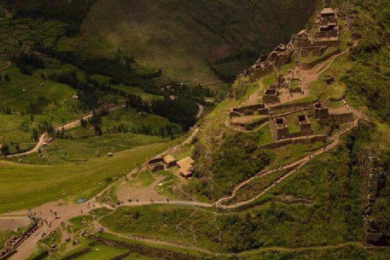
Pisac
Suni
-
Overland
-
Easy
-
Half-day
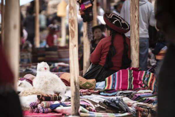
Known for its remarkable ruins, as well as for its colorful crafts market, the village of Pisac bears witness to the accomplishments and mysteries...
More details >Pisac
-
Exploration Path
Known for its remarkable ruins, as well as for its colorful crafts market, the village of Pisac bears witness to the accomplishments and mysteries of the Inca civilization.
This exploration allows travellers to discover, by foot, this key enclave of the Sacred Valley, showing an integral vision of the Inca cosmovision.
- m - ft
- m - ft
3.530 m 11.581 ft
2.945 m 9.662 ftElevation Profile
Chinchero
Suni
-
Overland
-
Easy
-
Half-day
Just 1 hour away from explora, between Urubamba and Cuzco, the village of Chinchero (3762 masl) is believed to be the birthplace...
More details >Chinchero
-
Exploration Path
Just 1 hour away from explora, between Urubamba and Cuzco, the village of Chinchero (3762 masl) is believed to be the birthplace of the Sacred Valley’s textile craftsmanship, as well as a hub for local trade.
This exploration takes travellers through the colonial streets of Chinchero by foot, visiting the village’s adobe church and discovering the unique murals preserved within.
- m - ft
- m - ft
3.860 m 12.664 ft
2.945 m 9.662 ftElevation Profile
-
Other options: