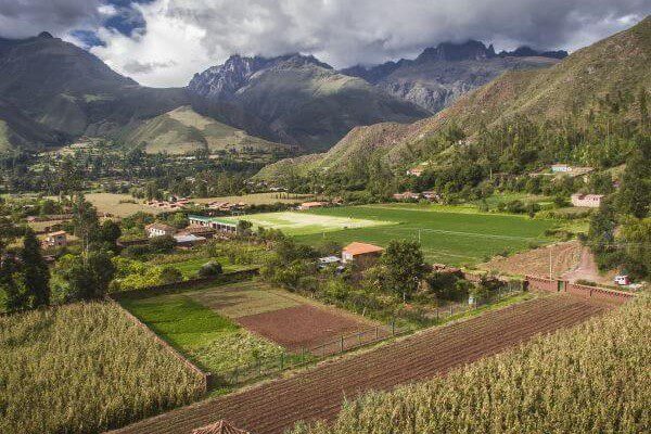
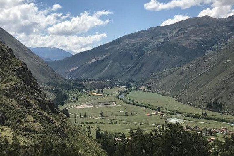
Sacred Valley
Sacred Valley of the Incas, Peru
Explorations in
Sacred Valley
Activity
Difficulty
Areas
Full Day Inca Trail
Quechua
-
 Hike
Hike -
Moderate
-
Full-day
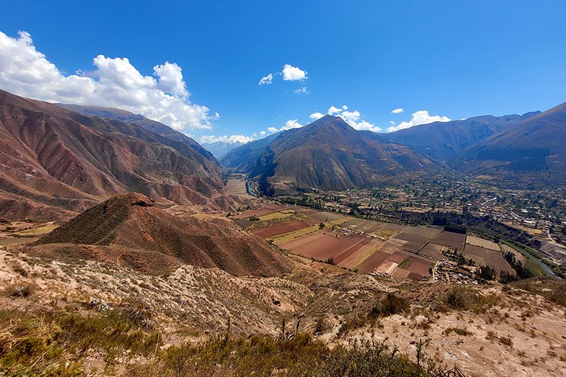
Embark on an unforgettable trekking exploration along one of the world's most iconic trails. Follow in the footsteps of the ancient Incas on the famous Qhapaq Ñan, the royal road network of the Inca Empire, as you trek on foot to the legendary Machu Picchu.
More details >Full Day Inca Trail


-
Exploration Path
Embark on an unforgettable trekking exploration along one of the world's most iconic trails. Follow in the footsteps of the ancient Incas on the famous Qhapaq Ñan, the royal road network of the Inca Empire, as you trek on foot to the legendary Machu Picchu.
Starting with a scenic train ride to the trailhead, the journey unfolds through lush cloud forests, over ancient stone steps and through timeless mountain tunnels, culminating in an awe-inspiring arrival at the Sun Gate (Inti Punku) - the grand entrance to the legendary Machu Picchu, just as the Incas experienced it centuries ago.
*Exploration coordinated with services provided by third parties (subject to availability). Additional cost of USD $1,190 per person. A minimum of two participants is required to carry out the exploration.”
We recommend booking this exploration with anticipation directly through us at reserve@explora.com.
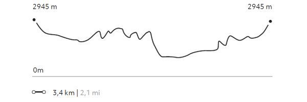
861 m 2825 ft
-587 m -1926 ft
2.713 m 8.901 ft
2.169 m 7.116 ftElevation Profile
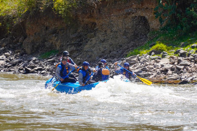
Wilkamayu
Quechua
-
Combination
-
Easy
-
Full-day
Ideal for travelers seeking a deep connection with nature through a contrasting rafting experience, where the most vital river of The Inca Empire, The Urubamba River, sets the pace across its sacred waters.
More details >Wilkamayu


-
Exploration Path
Ideal for travelers seeking a deep connection with nature through a contrasting rafting experience, where the most vital river of The Inca Empire, The Urubamba River, sets the pace across its sacred waters.
After a visit to one of the most emblematic Inca archaeological destinations, Ollantaytambo Village, we will embark into rafting experience suitable for all. This exploration offers ample opportunities to learn about the northwest region of the Sacred Valley. The ancient archaeological sites can be treasured from a completely different and intimate perspective, fostering a connection with the region's unique flora and fauna. The experience is complemented with a traditional Peruvian lunch in Cachicata, surrounded by nature at the river's edge. The buffet features local ingredients, prepared by the community itself.
*Exploration coordinated with services provided by third parties (subject to availability). Additional cost of USD $350 per person. A minimum of two participants is required to carry out the exploration.
Contact our reservations team for more details at reserve@explora.com.
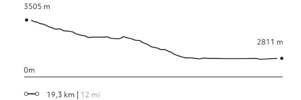
177 m 581 ft
-146 m -479 ft
3.505 m 11.499 ft
2.841 m 9.321 ftElevation Profile
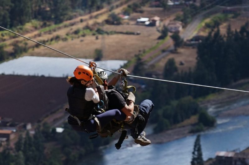
Pachar
Quechua
-
Climbing
-
Moderate
-
Half-day
Perfect for those seeking an active and adventurous half-day to connect with nature and the sacred mountains of the Incas. With an adrenaline rush suitable for all, this exploration offers stunning views of the northwest region of the Sacred Valley, overlooking the Urubamba River and the surrounding villages and crops.
More details >Pachar

-
Exploration Path
Perfect for those seeking an active and adventurous half-day to connect with nature and the sacred mountains of the Incas. With an adrenaline rush suitable for all, this exploration offers stunning views of the northwest region of the Sacred Valley, overlooking the Urubamba River and the surrounding villages and crops.
Additionally, we'll discover Inca storehouses, natively known as colcas, and learn about the types of rock and flora that make up these magnificent mountains. All while scaling a 400-meter "vía ferrata" and soaring through the sky on over 2 kilometers of zipline.
*Exploration coordinated with services provided by third parties (Subject to availability). Additional cost of USD $400 per couple (If only one person attends, the cost remains the same; if more than two people are attending, each additional person pays USD $200).
Contact our reservations team for more details at reserve@explora.com.
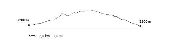
847 m 2.779 ft
-891 m -2923 ft
3.357 m 11.014 ft
2.806 m 9.206 ftElevation Profile
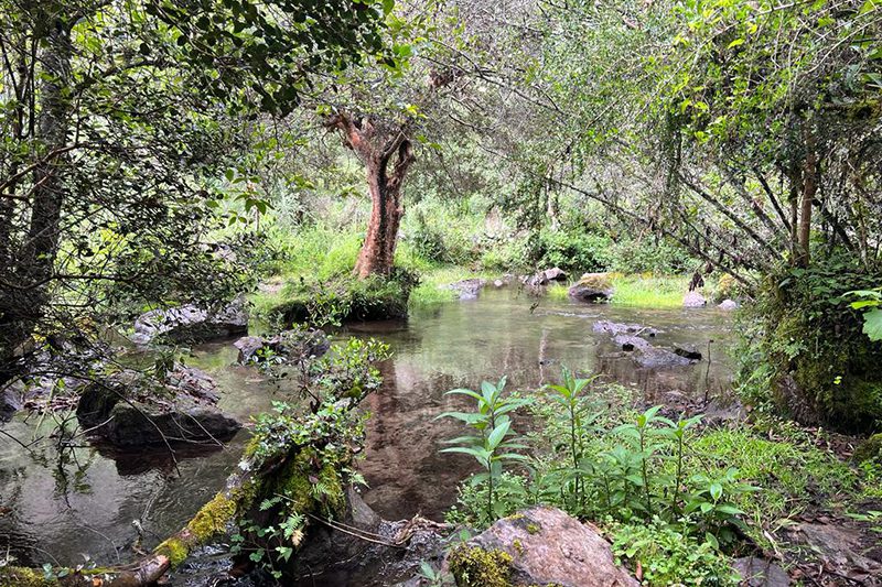
Yanahuara
Quechua
-
Hike
-
Easy
-
Half-day
Inside Quebrada Yanahuara, following a small stream that descends from the glaciers and crosses an ancient forest, we will find tremendous biodiversity with native trees over 200 years old. After leaving the gorge we will visit Enisfera, a private reserve that preserves hummingbirds, where we will observe these beautiful birds, which are characteristic of the valley.
More details >Yanahuara
-
Exploration Path
Inside Quebrada Yanahuara, following a small stream that descends from the glaciers and crosses an ancient forest, we will find tremendous biodiversity with native trees over 200 years old. After leaving the gorge we will visit Enisfera, a private reserve that preserves hummingbirds, where we will observe these beautiful birds, which are characteristic of the valley.
244 m 801 ft
-244 m -801 ft
3.357 m 11.014 ft
3.197 m 10.489 ftElevation Profile
Valle Sur
Quechua
-
Overland
-
Easy
-
Full-day
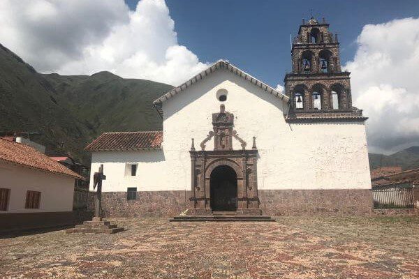
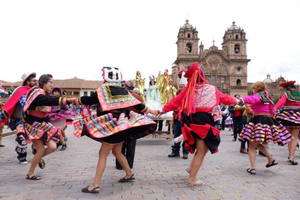
We will explore the Spanish influence through art and the religious syncretism that the cultural encounter fostered. We begin with a visit to the first of the three Canicunca churches, before walking to the Huaro church and then heading to the Andahuaylillas church, where we will visit the choir and the museum. We will end with lunch in a wetland accompanied by native birds.
More details >Valle Sur

-
Exploration Path
We will explore the Spanish influence through art and the religious syncretism that the cultural encounter fostered. We begin with a visit to the first of the three Canicunca churches, before walking to the Huaro church and then heading to the Andahuaylillas church, where we will visit the choir and the museum. We will end with lunch in a wetland accompanied by native birds.
Silvayoc
Quechua
-
Self Guided
-
Easy
-
Half-day
The hike visits archaeological sites with great historical value helping us connect with those who once inhabited the Sacred Valley.
More details >Silvayoc

-
Exploration Path
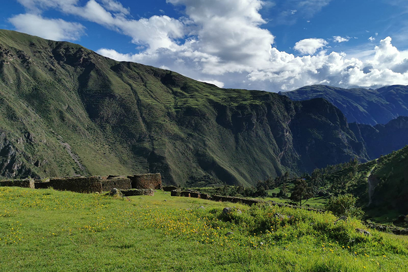
Explora’s plot is located in Urubamba, considered Peru’s archaeological capital. This 32-hectare area –encompassing four ancient properties– includes archaeological evidence that proves occupation since pre-Incan times. The hike visits archaeological sites with great historical value helping us connect with those who once inhabited the Sacred Valley.
28 m 99 ft
-28 m -99 ft
2.939 m 9.642 ft
2.914 m 9.560 ftElevation Profile
Huayabamba
Quechua
-
Self Guided
-
Easy
-
Half-day
Riding a bicycle through the explora’s surroundings is a good option for getting to know Urquillos, as well as getting to Huayllamba...
More details >Huayabamba
-
Exploration Path
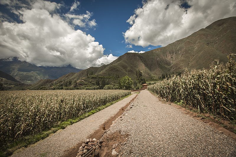
Riding a bicycle through the Explora’s surroundings is a good option for getting to know Urquillos, as well as getting to Huayllamba by following the course of the Urubamba River. This tour shows the farming nature of the area and the contrasts between one locality and the other.
267 m 876 ft
-275 m -902 ft
2.969 m 9.741 ft
2.867 m 9.406 ftElevation Profile
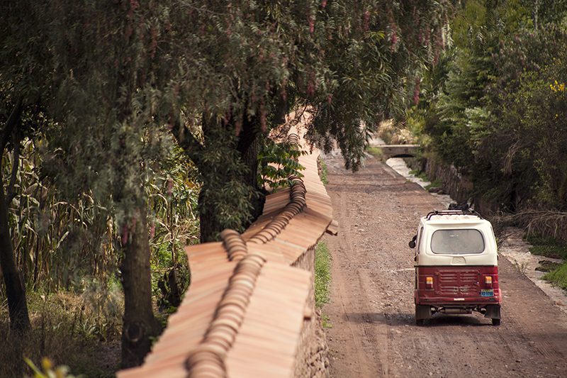
Urquillos
Quechua
-
Self Guided
-
Easy
-
Half-day
A good way to get to know the surroundings of Explora Valle Sagrado and the community of Urquillos, a hike where the active use of...
More details >Urquillos
-
Exploration Path
A good way to get to know the surroundings of Explora Valle Sagrado and the community of Urquillos, a hike where the active use of irrigation channels for local farming can be observed, where the quiet way of life and work prevailing in this area of the Sacred Valley is maintained.
72 m 236 ft
-71 m -233 ft
2.951 m 9.682 ft
2.904 m 9.528 ftElevation Profile
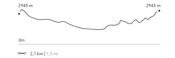
La Capilla
Quechua
-
Self Guided
-
Easy
-
Half-day
This hike up to the chapel located on the hillside behind the hotel offers views of the valley, cornfields and mountains. The chapel...
More details >La Capilla
-
Exploration Path
This hike up to the chapel located on the hillside behind the hotel offers views of the valley, cornfields and mountains. The chapel is a sample of the religious syncretism of this area where Catholicism and local traditions converge.
143 m 469 ft
-143 m -469 ft
2.948 m 9.672 ft
2.891 m 9.485 ftElevation Profile
Ayni
Quechua
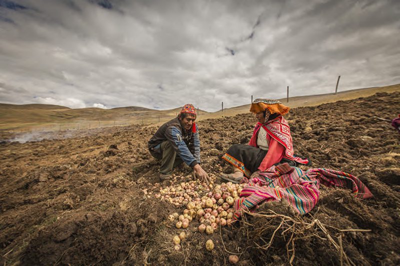
-
Overland
-
Easy
-
Full-day
We will visit the community of Huayllafara in the valley of Lamay, stopping along the way for a briefing on existing conservation projects...
More details >Ayni
-
Exploration Path
We will visit the community of Huayllafara in the valley of Lamay, stopping along the way for a briefing on existing conservation projects and then reaching the hike’s starting point. Once in the community, we will take part in farm work –based on the Andean calendar– learning about different local plants and crops. We will also get to know farming tools and techniques passed down through generations. Lunch will be prepared by community members using local produce.
Arin
Quechua
-
Hike
-
Easy
-
Half-day
Our hike begins in Huarán, on a narrow path that runs along an irrigation channel and different crops, with views of the valley and its ravines...
More details >Arin
-
Exploration Path
Our hike begins in Huarán, on a narrow path that runs along an irrigation channel and different crops, with views of the valley and its ravines; among them, that of Urquillos. We continue skirting the channel through forests of eucalyptus and smallholdings, until we come to a path by which we descend. Finally, we reach the community of Arín. We return to Explora by van.
* Not recommended for travelers with fear of heights.
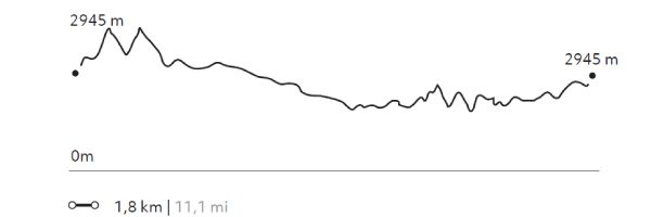
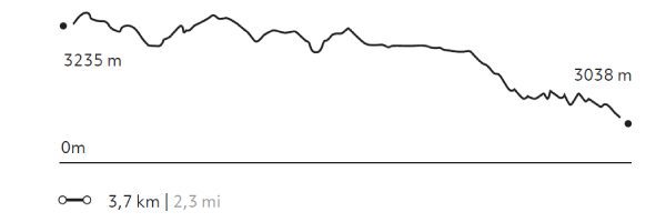
332 m 1.089 ft
-529 m -1.736 ft
3.253 m 10.673 ft
3.038 m 9.967 ftElevation Profile
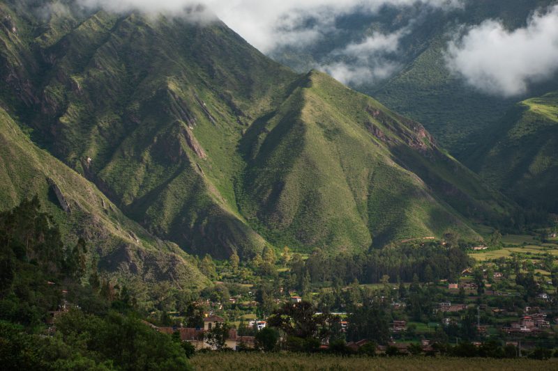
Cusco
Quechua
-
Overland
-
Easy
-
Full-day
This exploration shows the best of Cusco in one day. We will descend from the fortress of Saqsaywaman down crossing the al leys...
More details >Cusco
-
Exploration Path
This exploration shows the best of Cusco in one day. We will descend from the fortress of Saqsaywaman down crossing the al leys of the colonial quarter of San Blas to the main square. After lunch, the traveler can continue walking through Cusco with one of our guides or on his/her own. The temple of Corincan cha, on which the Santo Domingo convent was built, Museum of Pre-Columbian Art, the San Pedro Market, some Art Galleries or the hundreds of souvenirs stores are some of the options we recommend. * Tickets to the evening atractions are not included.
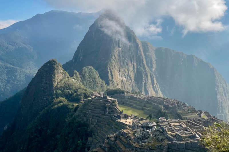
Machu-Picchu
Quechua
-
Overland
-
Easy
-
Full-day
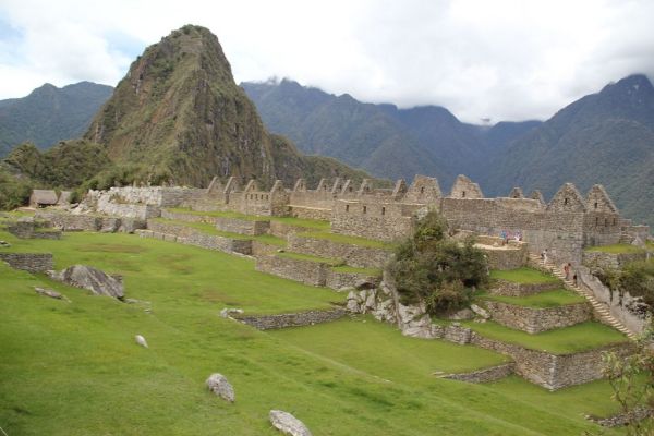
We explore the famous historical sanctuary of Machu Picchu, one of the most impressive architectural expressions of the Inca civilization.
More details >Machu-Picchu
-
Exploration Path
We explore the famous historical sanctuary of Machu Picchu, one of the most impressive architectural expressions of the Inca civilization. We leave the hotel towards the train station in Ollantaytambo, where we take the train to the town of Aguas Calientes to ascend to Machu Picchu by bus. We explore this magical place for approximately three hours. This version does not include the hike to Puerta del Sol or Inti Punku. Once we’ve visited the sanctuary, we leave Machu Picchu and head towards the station to take the train back.
*This exploration combines Explora services with third-party services, meaning it must be confirmed with our booking team at least 90 days before the visit. It has an additional cost of USD $430 for adults and USD $380 for children (up to 11 years). The exploration to Machu Picchu is provided through the rail company Perú Rail in the “Vistadome” or “Expedition” modality, depending on availability. The entrance to Machu Picchu must be at 11am. Alternatively, you can choose the Hiram Bingham train for a more luxurious experience, which comes with an additional cost.
To make your reservation, contact us by email at reserve@explora.com or phone us at +56 2 2395 2800.
Between Mountains
Quechua
-
Combination
-
Moderate
-
Full-day
From the heights of the slopes of Sacred Valley we will descend by bicycle on a track in good condition. The journey offers...
More details >Between Mountains
-
Exploration Path
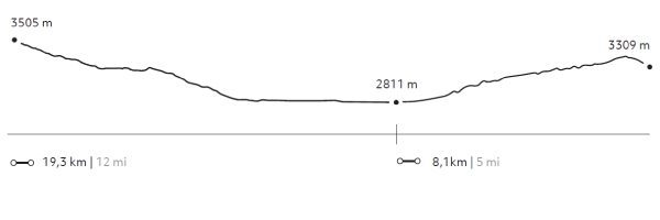
From the heights of the slopes of Sacred Valley we will descend by bicycle on a track in good condition. The journey offers very interesting views towards the mountains and the Urubamba river. Once the descent is finished, we will continue along a land parallel to the river, an area full of orchards and cornfields, as well as a great density of Inca terrace. We continue walking through Ollantaytambo, ascending a path with vegetation next to houses and orchards. The Pumamarca remains pose a conundrum to archeologists and explorers: their origins and functions are still unknown.
814 m 2.671 ft
-1.072 m -3.517 ft
3.510 m 11.516 ft
2.811 m 9.222 ftElevation Profile
Cuesta del Sapo
Quechua
-
Bike
-
Moderate
-
Half-day
From the heights of the Sacred Valley’s slopes we descend over a track in good conditions. The road offers very interesting views to the mountains...
More details >Cuesta del Sapo

-
Exploration Path
From the heights of the Sacred Valley’s slopes we descend over a track in good conditions. The road offers very interesting views to the mountains and the Urubamba river. Once downhill, we will continue bordering the river through an area of cornfields and orchards and densely packed Inca terraces.
163 m 535 ft
-858 m -2.815 ft
3.505 m 11.499 ft
2.811 m 9.222 ftElevation Profile
-
Other options: