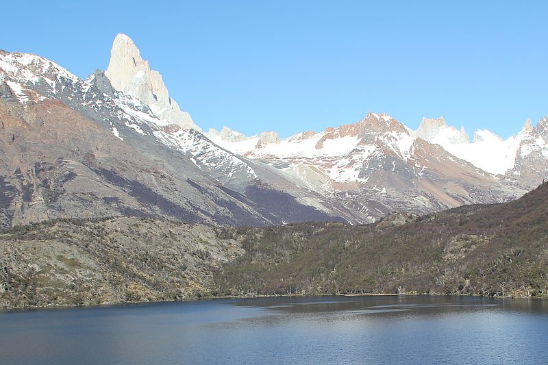
El Chaltén
Patagonia, Argentina
Explorations in
El Chaltén
Activity
Difficulty
Areas
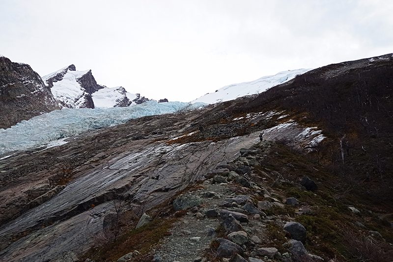
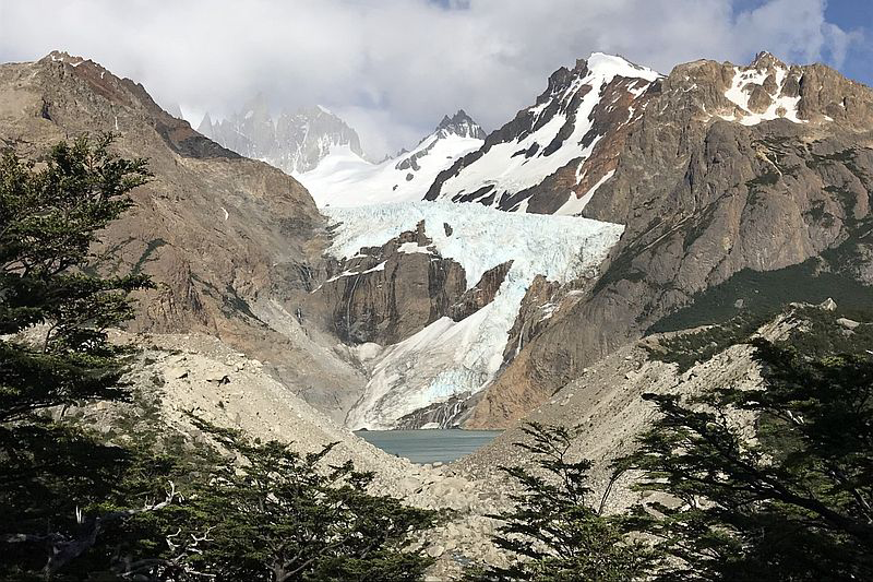
Glaciar Huemul
Lago del Desierto
-
 Hike
Hike -
Moderate
-
Half-day
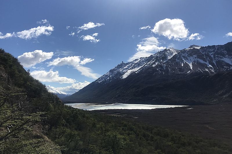
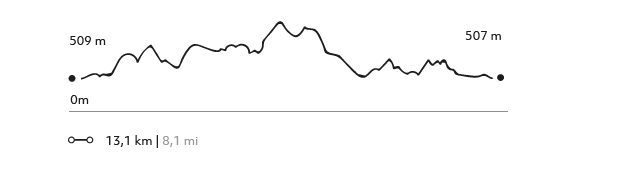
We take the van to the southern sector of the Lake of the Desert to begin hiking through a rainforest, where we will begin our ascent to Laguna Huemul, at the foot of the Glacier. We will pass through some clearings along the way where we will see the waterfalls that come down from the glaciers. We return along the same trail, with a panoramic view of the Laguna Huemul, Mount Fitz Roy and the Las Vueltas River valley.
More details >Glaciar Huemul


-
Exploration Path
We take the van to the southern sector of the Lake of the Desert to begin hiking through a rainforest, where we will begin our ascent to Laguna Huemul, at the foot of the Glacier. We will pass through some clearings along the way where we will see the waterfalls that come down from the glaciers. We return along the same trail, with a panoramic view of the Laguna Huemul, Mount Fitz Roy and the Las Vueltas River valley.
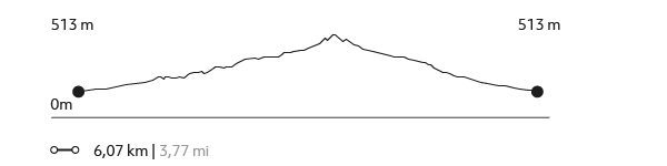
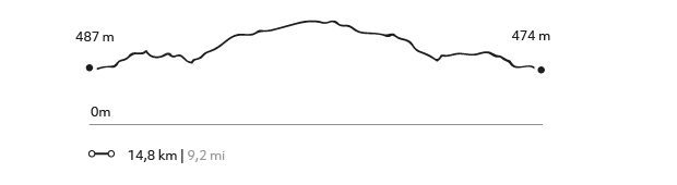
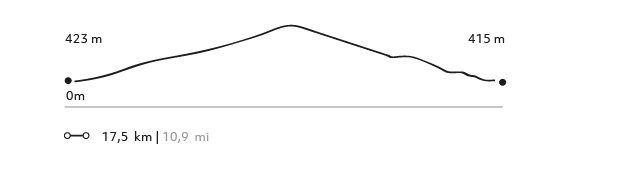
395 m 1296 ft
393 m 1291 ft
871 m 2858 ft
483 m 1583 ftElevation Profile
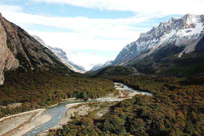
Laguna Pollone
Parque Nacional Los Glaciares
-
Hike
-
Advanced
-
Full-day
We begin by crossing the Eléctrico River and gradually enter a great nothofagus forest, accompanied by Patagonian birdsong the entire time. We then change landscape and move on to the sandy riverbanks of the Eléctrico River, with views of glaciers and mountain ranges up to Lake Eléctrico. We return along the same trail, which will give us other views of the valley.
More details >Laguna Pollone

-
Exploration Path
We begin by crossing the Eléctrico River and gradually enter a great nothofagus forest, accompanied by Patagonian birdsong the entire time. We then change landscape and move on to the sandy riverbanks of the Eléctrico River, with views of glaciers and mountain ranges up to Lake Eléctrico. We return along the same trail, which will give us other views of the valley.
264 m 865 ft
213 m 700 ft
712 m 2335 ft
433 m 1420 ftElevation Profile
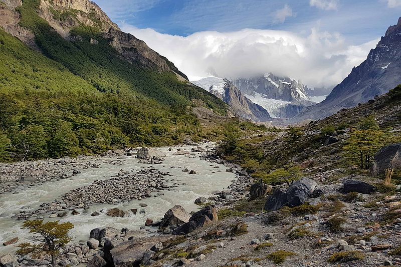
Laguna de los huemules
Los Huemules Conservation Reserve
-
Hike
-
Easy
-
Half-day
We hike from the lodge crossing a lenga and ñire forest, watching different types of birds and huemul deer tracks. We hike up to the Azul Lagoon, a water reserve that will reveal what has happened there. Different water birds will follow us along during this hike.
More details >Laguna de los huemules

-
Exploration Path
We hike from the lodge crossing a lenga and ñire forest, watching different types of birds and huemul deer tracks. We hike up to the Azul Lagoon, a water reserve that will reveal what has happened there. Different water birds will follow us along during this hike.
204 m 669 ft
-669 m -603 ft
603 m 1978 ft
487 m 1598 ftElevation Profile
Aves Patagónicas
Los Huemules Conservation Reserve

-
Hike
-
Easy
-
Half-day
We leave by van for Laguna Cóndor, where we will be able to observe and learn from the behavior of different types of birds in this region. The sector is home to a great diversity of birds, including some that can only be seen on this trail. We then hike through an ancient rainforest, whose characteristics make it a great place to see different types of owls.
More details >Aves Patagónicas
-
Exploration Path
We leave by van for Laguna Cóndor, where we will be able to observe and learn from the behavior of different types of birds in this region. The sector is home to a great diversity of birds, including some that can only be seen on this trail. We then hike through an ancient rainforest, whose characteristics make it a great place to see different types of owls.
158 m 518 ft
-146 m -479 ft
500 m 1640 ft
466 m 1529 ftElevation Profile
Laguna Cóndor
Los Huemules Conservation Reserve
-
Hike
-
Easy
-
Half-day
We will walk through a rainforest area, where biodiversity plays a key role. The route includes a gentle ascent along a rocky ledge, which will give us unique views and perspectives of the Las Vueltas River valley. Diverse birds can be observed in the Laguna sector.
More details >Laguna Cóndor
-
Exploration Path
We will walk through a rainforest area, where biodiversity plays a key role. The route includes a gentle ascent along a rocky ledge, which will give us unique views and perspectives of the Las Vueltas River valley. Diverse birds can be observed in the Laguna sector.
158 m 518 ft
-146 m -479 ft
500 m 1.640 ft
466 m 1.529 ftElevation Profile

Huemules
Los Huemules Conservation Reserve
-
Hike
-
Advanced
-
Full-day
Huemules
-
Exploration Path
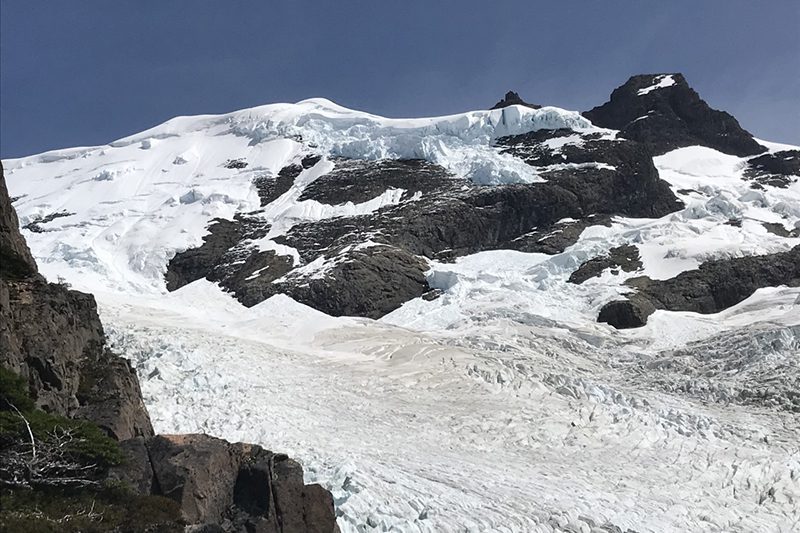
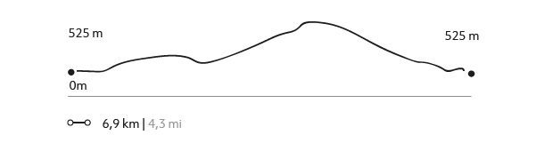
We take a slightly rugged track from the lodge to the Azul lagoon. Amidst rivers, mountains, and lagoons we amaze ourselves at the sight the north face of Mount Fitz Roy, while we continue our hike to the Diablo Lagoon. Finally, we reach a lookout with an ample view to the Cagliero Glacier, completing this full-day exploration to the Los Huemules Nature Reserve.
598 m 1961 ft
-598 m -1961 ft
812 m 2.664 ft
487 m 1.598 ftElevation Profile
Los Valles
Parque Nacional Los Glaciares
-
Hike
-
Expert
-
Full-day
We cross the Blanco river valley, then we hike up to the los tres lagoon. Enjoy an impressive view of Mount Fitz Roy.
More details >Los Valles

-
Exploration Path
An Explora van will take us to the northernmost tip of the Los Glaciares National Park. From there, we begin crossing the Blanco River valley. We then hike up to the Los Tres Lagoon, enjoying an impressive view of Mount Fitz Roy. We then follow the valley to the Torre Lagoon. We reach El Chaltén after one day with different lookouts within the Los Glaciares National Park, to return to the lodge by van.
1222 m 4009 ft
-1249 m -4098 ft
1.178 m 3.865 ft
426 m 1.398 ftElevation Profile
Lago del desierto
Lago del Desierto
-
Hike
-
Advanced
-
Full-day
We hike in the northernmost tip of the lake and take a rugged track through the forest, reaching some of the most unexplored parts of this area.
More details >Lago del desierto
-
Exploration Path
We take a van from the lodge to the south shore of the Desierto Lake. From there, we cross this historical lake while enjoying the view of the Vespigniani Glacier. We land on the northernmost tip of the lake and take a rugged track through the forest, reaching some of the most unexplored parts of this area. We reach the southern edge of the lake and finalize the exploration taking a van back to the lodge.
*Temporarily unavailable. Consult other exploration options with your Explora guide at the destination.
592 m 1942 ft
-588 m -1929 ft
660 m 2.165 ft
505 m 1.657 ftElevation Profile
Glaciar Vespigniani
Lago del Desierto
-
Hike
-
Advanced
-
Full-day
We cross the desierto lake- this historical lake- while enjoying the view of the Vespigniani Glacier.
More details >Glaciar Vespigniani
-
Exploration Path
We take a van from the lodge to the south shore of the Desierto Lake. From there, we cross this historical lake while enjoying the view of the Vespigniani Glacier. We land on the northernmost tip of the lake and take a rugged track through the forest, reaching some of the most unexplored parts of this area. We reach the southern edge of the lake and finalize the exploration taking a van back to the lodge.
*Exploration subject to availability operated by third parties.
**Wednesdays not available
727 m 2385 ft
-731 m -2398 ft
983 m 3.225 ft
518 m 1.699 ftElevation Profile
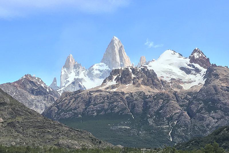
Laguna de los Tres
Parque Nacional Los Glaciares
-
Hike
-
Advanced
-
Full-day
Laguna de los Tres
-
Exploration Path
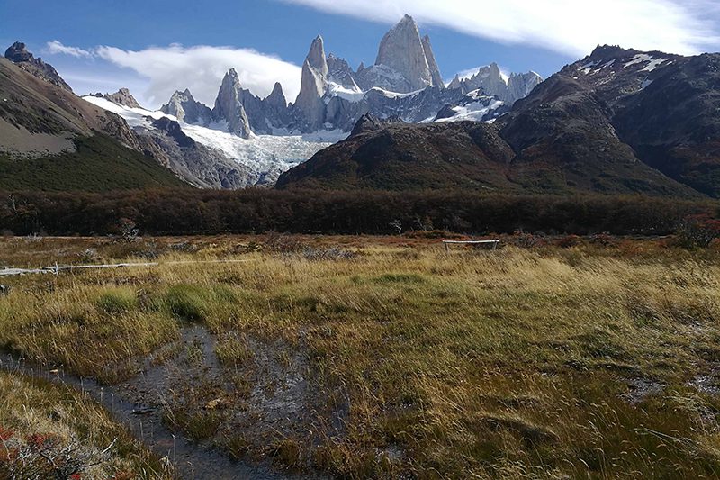
This exploration begins in one of the trails of the Los Glaciares National Park, hiking through forests and valleys up to the Los Tres Lagoon. We cross the river and begin ascending to the lagoon, where we will admire the magnificence of Mount Fitz Roy at its fullest.
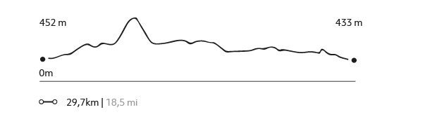
991 m 3251 ft
-1035 m -3396 ft
1.178 m 3.865 ft
401 m 1.316 ftElevation Profile

El Pliegue
Parque Nacional Los Glaciares
-
Hike
-
Advanced
-
Full-day
We begin in the south area of the Los Glaciares National Park, taking a trail to different valleys and a rise with a broad view to the Torre Mount.
More details >El Pliegue
-
Exploration Path
We begin in the south area of the Los Glaciares National Park, taking a trail to different valleys and a rise with a broad view to the Torre Mount, the Viedma Lagoon, and the Las Vueltas River valley. An ideal exploration to sit quietly and contemplate the mountains.
931 m 3054 ft
-931 m -3054 ft
1.286 m 4.219 ft
396 m 1.299 ftElevation Profile
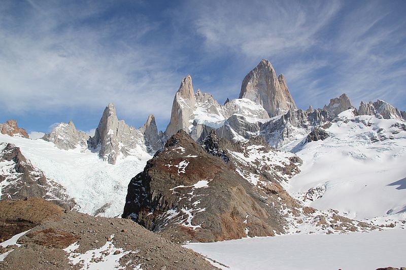
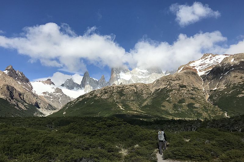
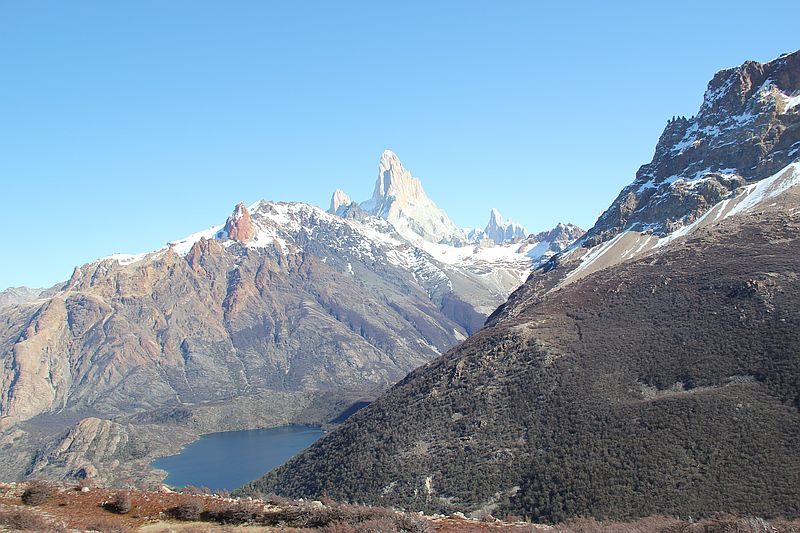
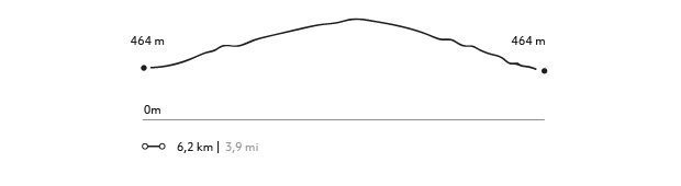
Laguna Torre
Parque Nacional Los Glaciares
-
Hike
-
Advanced
-
Full-day
From one of the accesses to El Chaltén, we hike up a trail and get an ample view to the Torre Mount.
More details >Laguna Torre
-
Exploration Path
From one of the accesses to El Chaltén, we hike up a trail to a valley with shrub-like vegetation and get an ample view to the Torre Mount.
510 m 1673 ft
-510 m -1673 ft
640 m 2.100 ft
426 m 1.398 ftElevation Profile
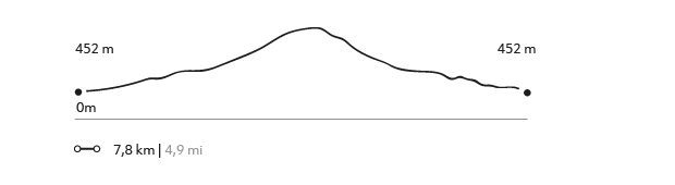
Piedras Blancas
Parque Nacional Los Glaciares
-
Hike
-
Moderate
-
Half-day
After a hike, we enjoy a view to the Piedras Blancas Glacier while learning about its history, formation, and dynamics.
More details >Piedras Blancas
-
Exploration Path
We take a van from the lodge and then begin our hike from the northern area of the Los Glaciares National Park. As we enter the forest, we enjoy a closer view to the Piedras Blancas Glacier while learning about its history, formation, and dynamics.
287 m 942 ft
-286 m -938 ft
704 m 2.310 ft
452 m 1.483 ftElevation Profile
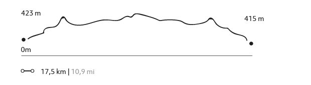
Valle de Granito
Parque Nacional Los Glaciares
-
Hike
-
Moderate
-
Full-day
We walk to the Los Glaciares National Park through a trail surrounded by forests with views to the area’s glaciers.
More details >Valle de Granito
-
Exploration Path
We walk to the Los Glaciares National Park through a trail surrounded by forests with views to the area’s glaciers. We will get an ample view of the Los Andes Mountain Range, with Mount Fitz Roy taking center stage. We finalize the hike at the town of El Chaltén and take the van back to the lodge.
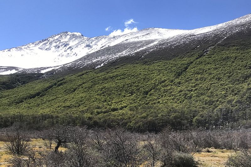
El Filo
Los Huemules Conservation Reserve
-
Hike
-
Advanced
-
Full-day
We begin this exploration hiking up the Loma del Diablo ridge, which will give us sweeping views of both the Diablo River valley as well as the Las Vueltas River valley. We will reach a high-altitude ecosystem with a dwarf forest, rocks and sandy banks, where we can register the magnitude of the environment we are in.
More details >El Filo
-
Exploration Path
We begin this exploration hiking up the Loma del Diablo ridge, which will give us sweeping views of both the Diablo River valley as well as the Las Vueltas River valley. We will reach a high-altitude ecosystem with a dwarf forest, rocks and sandy banks, where we can register the magnitude of the environment we are in.
574 m 1883 ft
-574 m -1883 ft
1.022 m 3.353 ft
463 m 1.519 ftElevation Profile
-
Other options: