Atacama
Desert & Altiplano, Chile
Explorations in
Atacama
Activity
Difficulty
Areas
Quebradas
Quebradas Intermedias
-
 Overland
 -
Easy
-
Half-day
We take a van to the Yerbas Buenas archaeological site located in the Domeyko Mountain Range. Here we can see...
More details >Quebradas


-
Exploration Path
We take a van to the Yerbas Buenas archaeological site located in the Domeyko Mountain Range. Here we can see different styles of petroglyphs.
We continue to the Rainbow Valley, where a special formation with varied shades of colors welcomes us to walk through the valley.
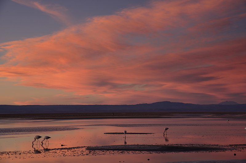
Gran Salar
Cuenca del salar
-
Overland
-
Easy
-
Half-day
We leave in a van to Toconao, located to the south of San Pedro de Atacama. We walk to the village square and then through an area...
More details >Gran Salar
-
Exploration Path
We leave in a van to Toconao, located to the south of San Pedro de Atacama. We walk to the village square and then through an area of vegetable gardens. We finally take a van to the Chaxa Lagoon, located in the Los Flamencos National Reserve, an ideal place for bird watching within Atacama’s Salt Flat.
Kunza
Cuenca del salar
-
Overland
-
Easy
-
Half-day
In this exploration we learn about the Atacameño history and culture. We start with a guided tour of an archaeological deposit...
More details >Kunza
-
Exploration Path
In this exploration we learn about the Atacameño history and culture. We start with a guided tour of an archaeological deposit where we can see ceramic pieces and other historical artifacts fit for a museum. Later on, we move on to the village of Tulor, one of the first settlements. We end the exploration at the mythical desert bookstore.
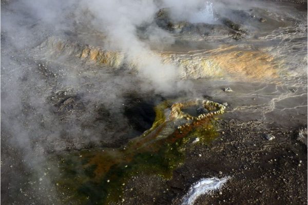
Reserva Tatio
Altiplano
-
Overland
-
Easy
-
Half-day
We take a van to the Tatio Geysers. Along the way, an important part of the Andean Plateau fauna –including vicuñas, flamingos, foxes...
More details >Reserva Tatio
-
Exploration Path
We take a van to the Tatio Geysers. Along the way, an important part of the Andean Plateau fauna –including vicuñas, flamingos, foxes, and others– can be appreciated. We walk across the reserve feeling the inner activities of the land with views to the Andes Mountain Range and the hot water springs from where steam rises. We return by van.
Catarpe
Cuenca del salar
-
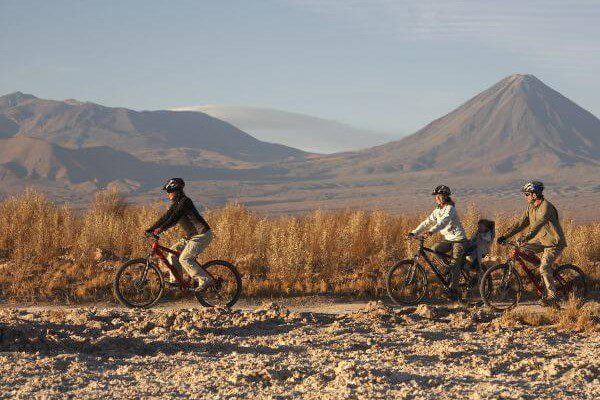
Bike
-
Easy
-
Half-day
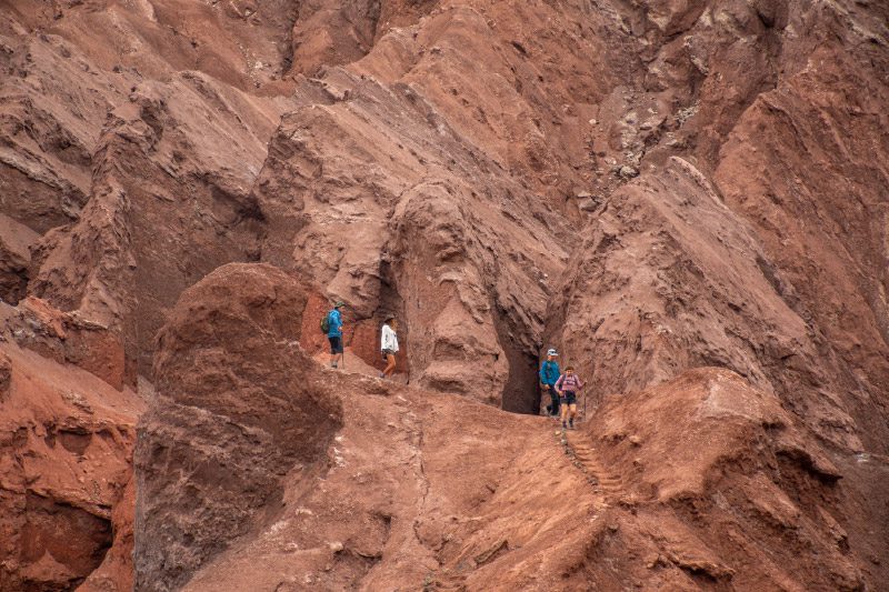
We bike ride to the San Pedro River and follow its course to Catarpe. We go through the Quitor pukará...
More details >Catarpe

-
Exploration Path
We bike ride to the San Pedro River and follow its course to Catarpe. We go through the Quitor pukará, an old fortress, and cross the Garganta del Diablo (Devil’s Throat), a canyon inside the Salt Mountain Range with zigzagging paths between striking rock formations. We return through the same road.
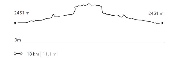
244 m 801 ft
-244 m -801 ft
2.546 m 8.353 ft
2.431 m 7.976 ftElevation Profile
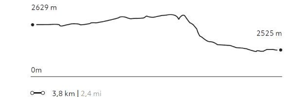
Ckuta
Cuenca del salar
-
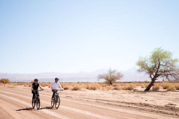
E-Bike
-
Easy
-
Half-day
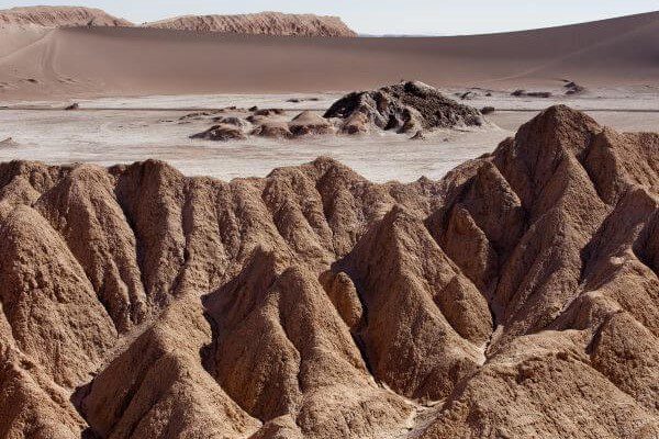
We take a van to the Salt Mountain Range and begin bike riding in the Paciencia plains. We travel to the Moon Valley through...
More details >Ckuta
-
Exploration Path
We take a van to the Salt Mountain Range and begin bike riding in the Paciencia plains. We travel to the Moon Valley through sandy soil and beautiful landscapes. The return trip is an uneven path that includes different ascents and descents.
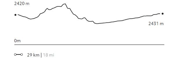
251 m 823 ft
-240 m -787 ft
2.488 m 8.163 ft
2.366 m 7.762 ftElevation Profile
Dunas de la Chula
Cuenca del salar
-
Horseback Ride
-
Easy
-
Half-day
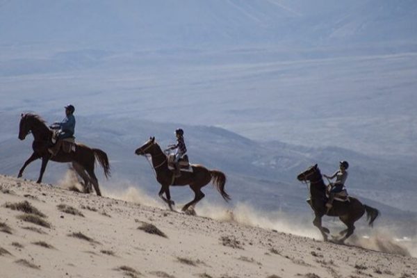
We horseback ride to the Salt Mountain Range. We go across the San Pedro River and sand dunes, from where we have panoramic views...
More details >Dunas de la Chula

-
Exploration Path
We horseback ride to the Salt Mountain Range. We go across the San Pedro River and sand dunes, from where we have panoramic views of the Andes Mountain Range and the oasis. Afterwards, we follow through a dry riverbed and comeback to Explora through the pampa.
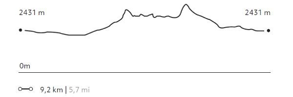
114 m 374 ft
-114 m -374 ft
2.481 m 8.140 ft
2.410 m 7.907 ftElevation Profile
Solor
Cuenca del salar
-
Horseback Ride
-
Easy
-
Half-day
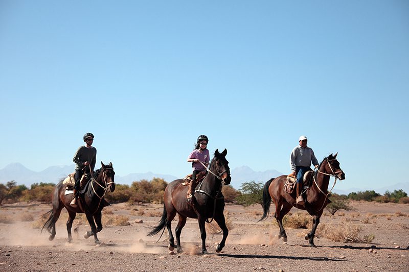
We travel to the ayllu in Solor, located to the south of San Pedro. Here we can see one of the oasis’s most developed farming areas...
More details >Solor
-
Exploration Path
We travel to the ayllu in Solor, located to the south of San Pedro. Here we can see one of the oasis’s most developed farming areas. On our way, we can see typical desert constructions –using adobe and straw roofs– and we go across a small irrigation canal. Before we return, we visit the mythical Librería del desierto.
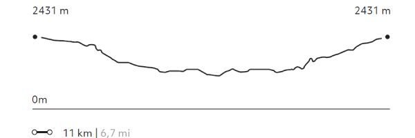
64 m 211 ft
-64 m -211 ft
2.431 m 7.974 ft
2.400 m 7.872 ftElevation Profile
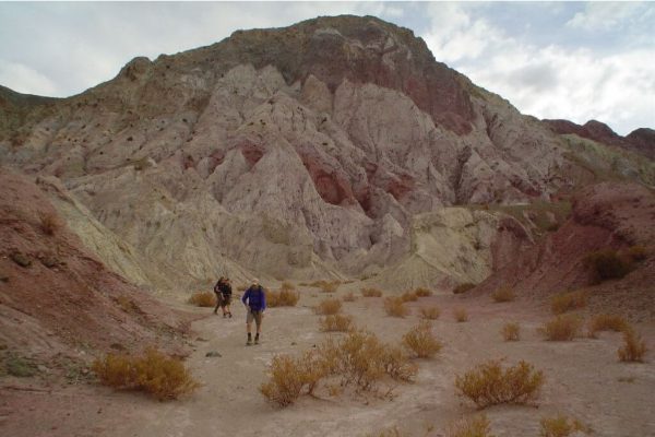
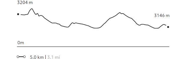
Matancilla
Quebradas Intermedias
-
Hike
-
Easy
-
Half-day
We take a van to the Domeyko Mountain Range where we walk following a creek that used to be a route for gathering and bartering caravans...
More details >Matancilla

-
Exploration Path
We take a van to the Domeyko Mountain Range where we walk following a creek that used to be a route for gathering and bartering caravans. The walk ends at the Rainbow Valley formed by huge multicolored walls of mineral-rich soils. We return by van.
204 m 669 ft
-263 m -863 ft
3.231 m 10.600 ft
3.134 m 10.282 ftElevation Profile
Huayra
Cuenca del salar
-
Hike
-
Easy
-
Half-day
We take a van to the Mars Valley in the Salt Mountain Range, where we begin a walk with views to the different mountain ranges...
More details >Huayra
-
Exploration Path
We take a van to the Mars Valley in the Salt Mountain Range, where we begin a walk with views to the different mountain ranges in the region and felling the wind of the area. We descend through sand dunes and continue walking across the valley, where the van will be waiting to take us back.
Please note: Not available on Mondays.
59 m 194 ft
-204 m -669 ft
2.790 m 9.154 ft
2.614 m 8.574 ftElevation Profile
-
Other options: