Amid the sea, magma and ice: How was the Massif Paine formed?
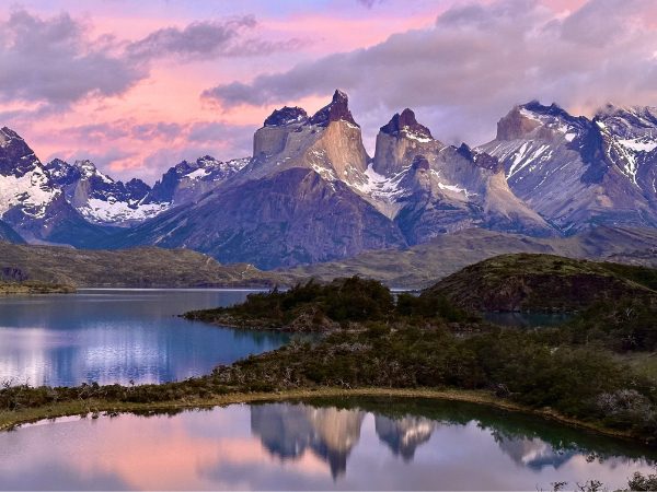
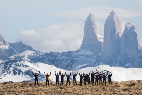
While Torres del Paine National Park – the most important one in Chile – has many geographical landmarks such as valleys, rivers, lakes and glaciers, the most emblematic and most visited by the thousands of tourists who come to this place every year is its huge massif. This is because its unique geomorphology leaves visitors speechless, while revealing the beautiful history of a specific geological process that took place in this territory over the course of millions of years. The emblematic Cuernos del Paine stand out among its mountains as the main image that all travelers who visit this wonderful place every year take home with them. How was the Paine massif formed? We tell you about it below.
Recognized by the Unesco as a Biosphere Reserve in 1978 and chosen as the Eighth Wonder of the World in 2013, Torres del Paine National Park is a unique natural spectacle in the world. This is because its mountains, which contrast with the surrounding rugged environment, form one of the most incredible landscapes on the planet. Its shapes and colors challenge reality and give account of a geological history dating back millions of years.
While the Torres del Paine National Park in the Magallanes y Antárctica Chilena Region, 154 kilometers northwest of Puerto Natales and 399 kilometers from Punta Arenas, has many geographical landmarks such as valleys, rivers, lakes and glaciers, its huge massif is the most emblematic one and the most visited by the thousands of tourists who arrive at the park every year, consisting of the peaks Paine Grande, the Cuernos del Paine, Fortaleza, Escudo, Cerro Almirante Nieto and the famous Torres del Paine.
The truth is that these mountains have a unique geomorphology that leaves visitors speechless, while revealing endless specific geological processes that took place in this territory over the course of millions of years. The emblematic Cuernos del Paine stand out among its fascinating mountains, the main image that all travelers who visit this wonderful place every year take home with them.
As the prominent paleontologist Juan Enrique Bostelmann says: “We could say that the Paine massif is a lateral activation of the Andes Mountains. If you look at a map you can see the axis of the mountains perfectly; the Paine massif sticks out a bit toward the east within the relief but is clearly aligned with the mountain range’s axis. It corresponds to a set of elevations, of mountains that are composed of two core elements: A box rock made up of Upper Cretaceious marine units, sedimentary rocks, which is what Cerro Toro and Punta are made up of and also represents a good part of Almirante Nieto and Paine Grande, and the remains of the intrusive element, which is a laccolith.”
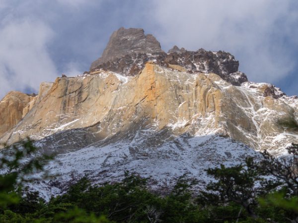
In other words, the Paine massif is part of the Andes Mountains and corresponds to a set of mountains composed of two totally different types of rocks. On the one hand we have sedimentary rocks composed of marine units originating in the Upper Cretaceous (about 90 million years ago) and on the other igneous rocks composed mainly of laccolith, or volcanic material formed in the earth’s crust due to an eruption or lava upwelling that failed to reach the surface.
It is a geological formation created about 12.5 million years ago, when a source of magma caused a laccolith intrusion through what is known as the Rio Nutria fault, amid the sedimentary rocks of the preexisting formations Punta Barrosa and Cerro Toro, which were formed approximately 90 million years ago at the bottom of the sea.
“In the case of the Paine massif, the cretaceous marine rocks, which are sedimentary rocks, are mainly shale, or rocks with a very fine and sandy grain. This is because these rocks were at the bottom of the sea 90 million years ago, an abyssal seabed, and there are only very finite particles on the seabed. The particles precipitate and when they are heavier, they fall closer to their source, but the finer they are, the thinner they become, the further they drift away and reach the seabed furthest away in the basin. Another characteristic of the seabed is that it lacks oxygen, which is why these rocks are black, because they are anoxic. This is what these box rocks in Torres del Paine are made up of,” the paleontologist adds.
There was a magma intrusion about 70 million years after these rocks formed at the bottom of the sea and subsequently emerged to the surface. They did not reach the surface after 4 different intrusions but managed to deform the relief, creating a sort of dome. “That’s why these are called box rocks, because they are rocks that hold the intrusive rock inside them, in this case a laccolith, which is an essentially flattened intrusive rock that extends horizontally and for a short geographical distance and is made up of granitoids or granites,” Bostelmann notes.
Ultimately, the landscape that we see today was transformed by glaciers, which during different glaciation periods – which reached their peak about 18,000 years ago – and due to continuous erosion gave shape to the valleys and mountains, revealing the laccolith that had remained hidden beneath the surface. This explains the differences in colors and shades that are so characteristic and representative of Torres del Paine, where the grayish blue of the granites contrasts with the black of the shale, giving account of two totally different geological processes that took place tens of millions of years apart.
Thus, the ice, one of the biggest erosive forces that exists, modeled the emblematic and striking angular shapes of the summits, configuring these characteristics that give the landscape a scenic beauty that is unique in the world and offers scientists the rare chance to study the different processes that have shaped our planet as we know it.
“The geography of Torres del Paine is so unique and stands out because it is a beautiful testimony to a specific geological process and it is very impressive because the glaciations have given it these astounding shapes and allowed it to be exposed so beautifully, with the granites contrasting with the rest of the rock. This makes it an excellent place to bring people closer to geology so they can recognize processes that take place on the surface, under the surface and those associated with erosion, in addition to recognizing all this as part of a shifting landscape that has transformed over millions of years. These mountains are evidence of a process that teaches us that the earth, like living beings, is dynamic and changes over time; it superimposes things and it ages. The thing is that it does so over time scales that are very difficult for humans to comprehend because they are so long, but with the same dynamism as life,” the paleontologist concludes.