Torres del Paine
Patagonia, Chile
Explorations in
Torres del Paine
Activity
Difficulty
Areas
Puma Encounters
Estepa
-
 Overland
 -
Easy
-
Full-day
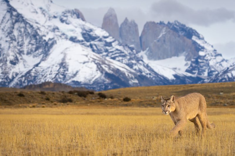
An exploration that invites you to responsibly observe pumas in their natural habitat. Accompanied by expert guides, you will explore the stunning landscapes of Patagonia and have the chance to observe this iconic feline.
We invite you to experience the thrill of venturing into puma territory.
This exploration is available exclusively for guests aged 18 and over.
*Exploration coordinated with services provided by third parties (subject to availability). Additional cost of USD 2,700 for a single traveler and USD 1,550 per person for groups of 2 to 6 travelers.
We recommend booking this exploration in advance directly through us at reserve@explora.com
More details >
Puma Encounters


-
Exploration Path
An exploration that invites you to responsibly observe pumas in their natural habitat. Accompanied by expert guides, you will explore the stunning landscapes of Patagonia and have the chance to observe this iconic feline.
We invite you to experience the thrill of venturing into puma territory.
This exploration is available exclusively for guests aged 18 and over.
*Exploration coordinated with services provided by third parties (subject to availability). Additional cost of USD 2,700 for a single traveler and USD 1,550 per person for groups of 2 to 6 travelers.
We recommend booking this exploration in advance directly through us at reserve@explora.com
AONIKENK
Estepa
-
Hike
-
Moderate
-
Half-day
We travel by van to the eastern sector of the park, where we hike, exploring the wildlife. During the walk, we visit a cave...
More details >AONIKENK


-
Exploration Path
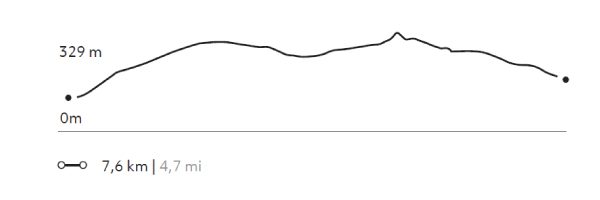
We travel by van to the eastern sector of the park, where we hike, exploring the wildlife. During the walk, we visit a cave with paintings that are over 4,000 years old. We can observe the geese, ducks and swans in the lagoons that are on the way. The terrain has various ascents and descents without steep slopes. Return by van.
303 m 994 ft
-237 m -778 ft
329 m 1.079 ft
95 m 312 ftElevation Profile
PUNTILLA DEL TORO
Estepa
-
Horseback Ride
-
Easy
-
Half-day
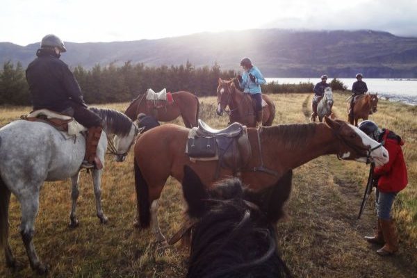
We leave the stables on horseback, riding across the Serrano pampa and passing lagoons with the Paine massif behind us. We will ride along the banks of the Serrano River and Lake Toro, which we will cross at different points. We will return via the pampa with views of the Paine massif.
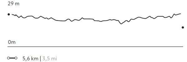
More details >PUNTILLA DEL TORO

-
Exploration Path
We leave the stables on horseback, riding across the Serrano pampa and passing lagoons with the Paine massif behind us. We will ride along the banks of the Serrano River and Lake Toro, which we will cross at different points. We will return via the pampa with views of the Paine massif.
14 m 46 ft
-14 m -46 ft
30 m 98 ft
26 m 85 ftElevation Profile
SERRANO
Estepa
-
Horseback Ride
-
Advanced
-
Half-day
We depart from the stables riding on a plain along the Serrano River. Then, we cross some paths to a viewpoint...
More details >SERRANO

-
Exploration Path
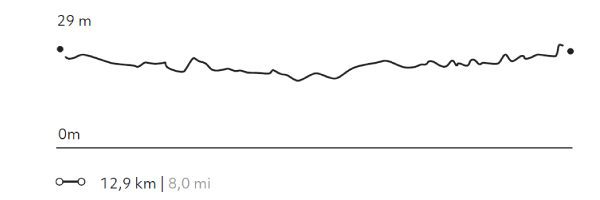
We depart from the stables riding on a plain along the Serrano River. Then, we cross some paths to a viewpoint from where we see a village on the outskirts of the park and the immensity of the plain that surrounds us. On the way back, we cross a small forest.
* For experienced and advanced riders only. This exploration is only available for advanced riders who have mastered rising trot and canter over uneven terrain in open spaces and on all types of horses. Advanced riders are physically fit and able to canter for long stretches without getting tired.
31 m 102 ft
-31 m -102 ft
30 m 98 ft
28 m 92 ftElevation Profile
Pioneros
Estepa
-
Overland
-
Easy
-
Half-day
We will visit the south-west area of the park, making various stops and short walks that will allow us to discover important landmarks...
More details >Pioneros
-
Exploration Path
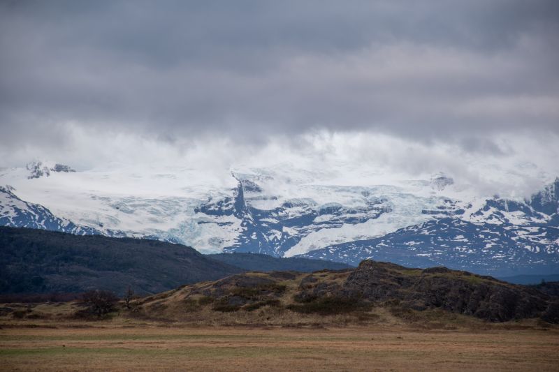
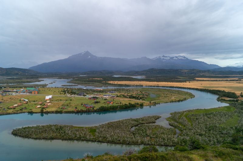
We will visit the south-west area of the park, making various stops and short walks that will allow us to discover important landmarks in the history of Patagonia and the national park. We will cross various ecosystems associated with higher humidity, such as the banks of the Serrano River or the Lenga and Ñirre forests. We will have the opportunity to see various types of waterfowl, while we make stops to observe the lake and Gray Glacier, share a tea and enjoy one of the best views of the Paine massif.
ESTEPA PATAGÓNICA
Estepa

-
Overland
-
Easy
-
Half-day
We travel through the eastern sector of the park combining stretches in van with short walks...
More details >ESTEPA PATAGÓNICA
-
Exploration Path
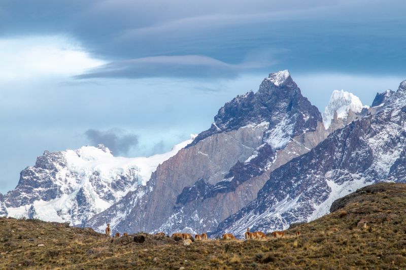
We travel through the eastern sector of the park combining stretches in van with short walks. This sector is mainly characterized by the presence of animals such as guanacos, pumas and diversity of birds, as well as its extensive pampas, typical of the Patagonian steppe. First we visit the Nordenskjöld Lake viewpoint and the Paine Grande waterfall, then we travel by van to the Los Cisnes Lagoon and finally to the Amarga Lagoon.
*Available only select months of the year according to the activity of the estancieros. Coordinated at the destination.
SARMIENTO
Estepa
-
Hike
-
Easy
-
Half-day
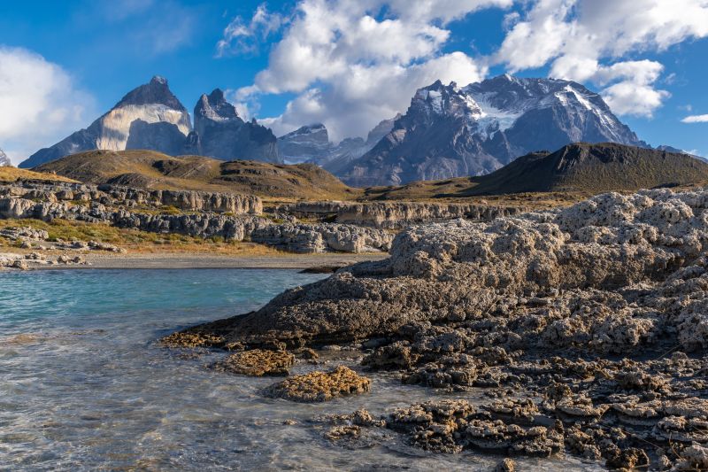
We will walk along a trail with low vegetation and views of the Paine Horns and Almirante Nieto. We then go down to the beach on the shores of Lake Sarmiento, where we will have the chance to walk among incredible calcium carbonate rock formations.
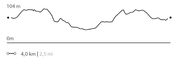
More details >SARMIENTO
-
Exploration Path
We will walk along a trail with low vegetation and views of the Paine Horns and Almirante Nieto. We then go down to the beach on the shores of Lake Sarmiento, where we will have the chance to walk among incredible calcium carbonate rock formations.
100 m 328 ft
-100 m -328 ft
125 m 410 ft
80 m 262 ftElevation Profile
-
Other options: