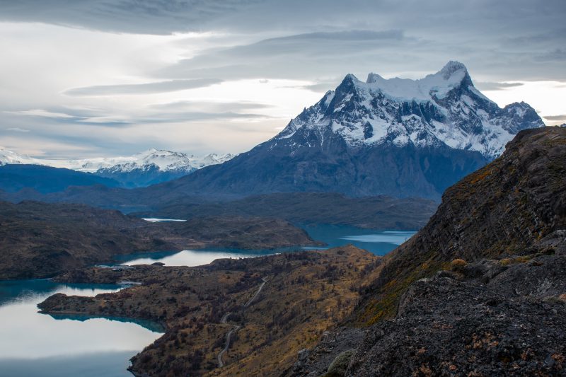
Torres del Paine
Patagonia, Chile
Explorations in
Torres del Paine
Activity
Difficulty
Areas
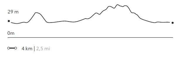
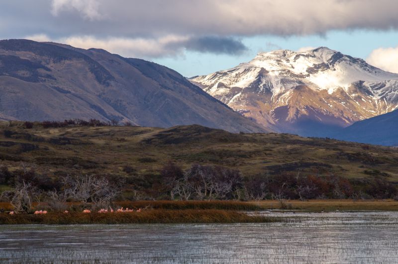
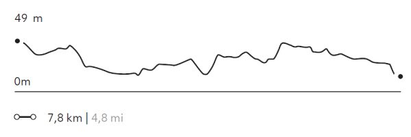
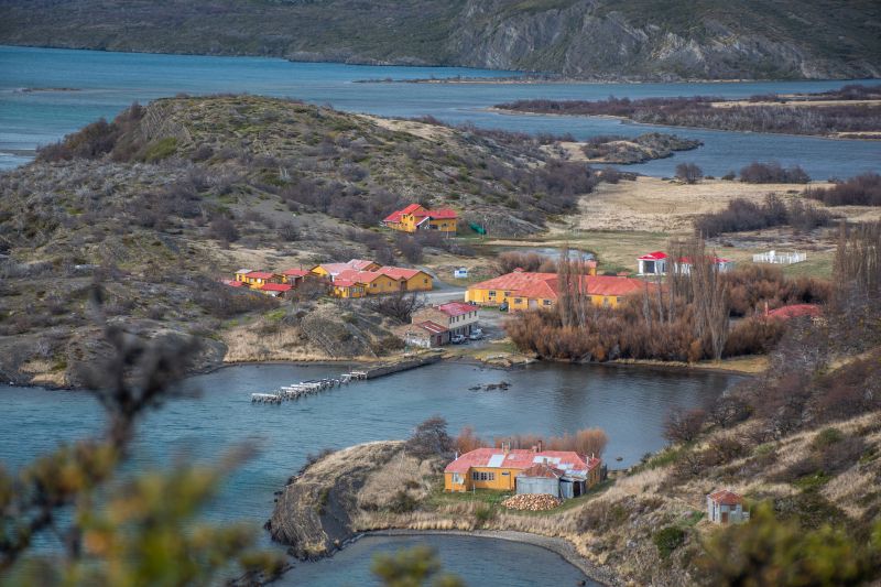
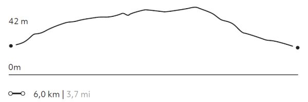
LAGUNA NEGRA
Encuentro
-
 Horseback Ride
 -
Easy
-
Half-day
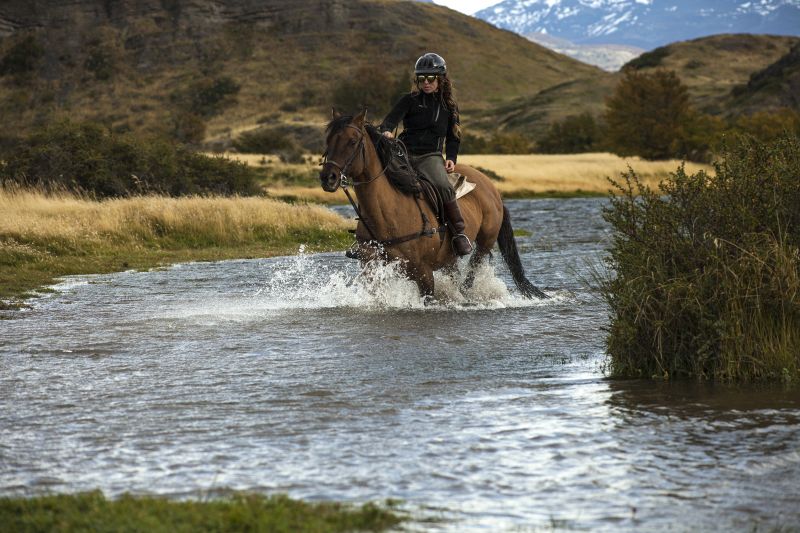
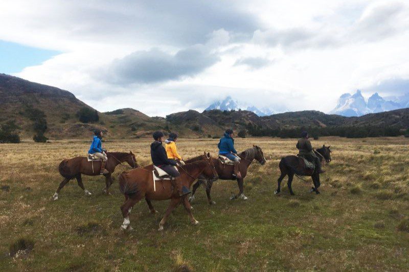
We depart from the stables and ride across rivers, forests and pampas as we ascend towards the viewpoint of the Negra Lagoon...
More details >LAGUNA NEGRA


-
Exploration Path
We depart from the stables and ride across rivers, forests and pampas as we ascend towards the viewpoint of the Negra Lagoon. On the way we pass by several lagoons, ideal for spotting different species of birds such as Queltehues or Magellanic geese.
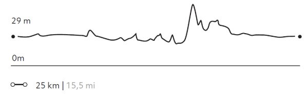
54 m 177 ft
-54 m -177 ft
53 m 174 ft
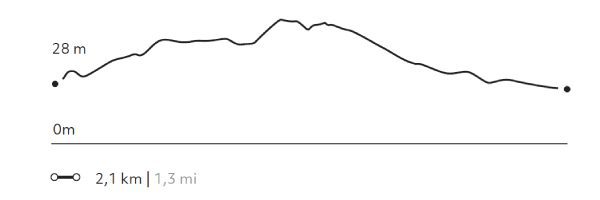
28 m 92 ftElevation Profile
DONOSITO
Encuentro
-
Horseback Ride
-
Advanced
-
Half-day
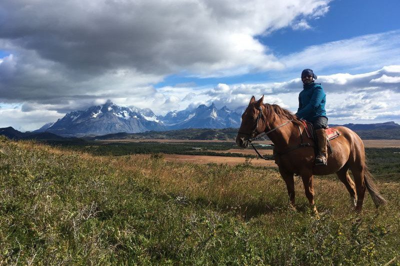
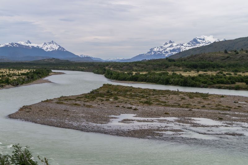
We depart from the stables riding through the Serrano pampas, cross the Grey bridge and ride along the river bank...
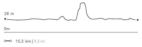
More details >DONOSITO

-
Exploration Path
We depart from the stables riding through the Serrano pampas, cross the Grey bridge and ride along the river bank. From there, we ascend a hill with dense vegetation. We pass through wetlands until we reach the Donosito viewpoint with views of the Serrano and Grey rivers, the plain and the Paine massif.
* For experienced and advanced riders only. This exploration is only available for advanced riders who have mastered rising trot and canter over uneven terrain in open spaces and on all types of horses. Advanced riders are physically fit and able to canter for long stretches without getting tired.
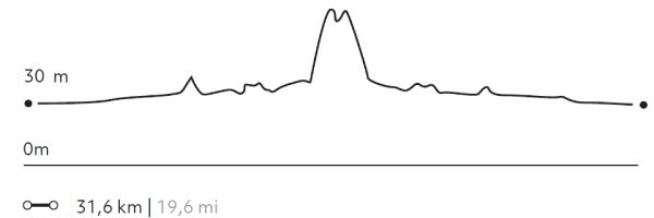
143 m 469 ft
-143 m -469 ft
101 m 331 ft
28 m 92 ftElevation Profile
DONOSO
Encuentro
-
Horseback Ride
-
Advanced
-
Full-day
We depart from the stables riding through the Pampa Serrano. We cross the Grey River and climb a hill crossing streams...
More details >DONOSO
-
Exploration Path
We depart from the stables riding through the Pampa Serrano. We cross the Grey River and climb a hill crossing streams, lagoons, plains and wetlands to the Donosito overlook with views of rivers, the Pampas and the Paine massif. We ascend up a narrow and pronounced path between trees to the Choros Lagoon. After lunch in the forest, we return to the stables.
* For experienced and advanced riders only. This exploration is only available for advanced riders who have mastered rising trot and canter over uneven terrain in open spaces and on all types of horses. Advanced riders are physically fit and able to canter for long stretches without getting tired.
260 m 853 ft
-260 m -853 ft
87 m 285 ft
14 m 46 ftElevation Profile
TÉMPANOS
Encuentro
-
Horseback Ride
-
Advanced
-
Full-day
We depart from the stables, galloping through plains and rocky terrain until we reach the banks of the Grey River...
More details >TÉMPANOS
-
Exploration Path
We depart from the stables, galloping through plains and rocky terrain until we reach the banks of the Grey River. We continue towards a hill, up a steep slope to the Témpanos viewpoint, from where we can see Grey Lake, its ice fields and the glacier in the distance.
* For experienced and advanced riders only. This exploration is only available for advanced riders who have mastered rising trot and canter over uneven terrain in open spaces and on all types of horses. Advanced riders are physically fit and able to canter for long stretches without getting tired.
505 m 1.657 ft
-505 m -1.657 ft
217 m 712 ft
28 m 92 ftElevation Profile
Aves Australes
Encuentro
-
Overland
-
Moderate
-
Full-day
Ideal for lovers of flora and fauna, this exploration takes place outside the park, in the surroundings of a lagoon...
More details >Aves Australes


-
Exploration Path
Ideal for lovers of flora and fauna, this exploration takes place outside the park, in the surroundings of a lagoon inhabited by different bird species. We hike while contemplating the varied vegetation and the behavior and sound of the birds. Between September and April, sightings increase due to the favorable conditions offered by spring and summer.
139 m 456 ft
-139 m -456 ft
49 m 161 ft
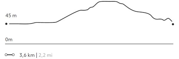
30 m 98 ftElevation Profile
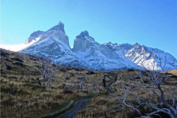
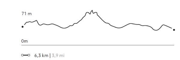
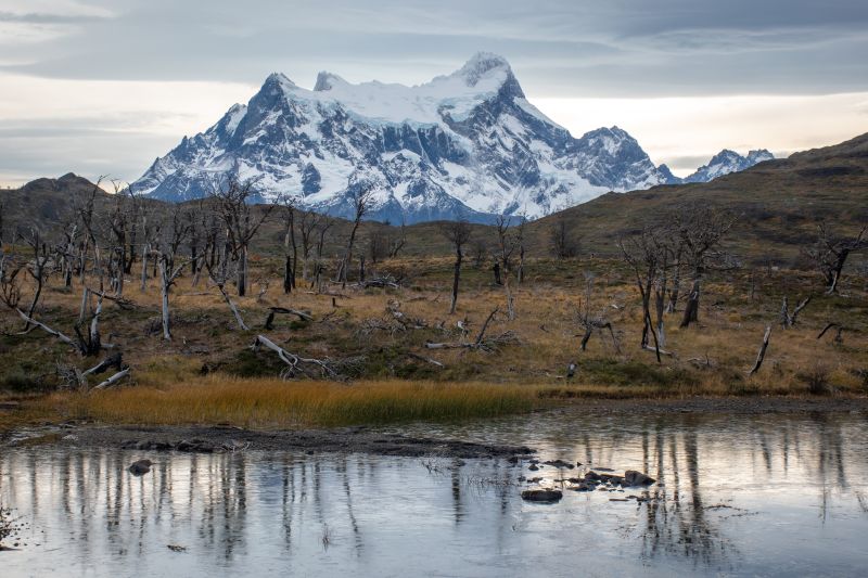
NORDENSKJÖLD
Encuentro
-
Hike
-
Easy
-
Half-day
We travel by van to Salto Grande and begin our trek with views of the Paine Grande and its hanging glaciers. Then, we reach the turquoise...
More details >NORDENSKJÖLD

-
Exploration Path
We travel by van to Salto Grande and begin our trek with views of the Paine Grande and its hanging glaciers. Then, we reach the turquoise waters of Lake Nordenskjöld, at the foot of the massif where the sound of breaking ice can occasionally be heard. We return to the lodge by van.
139 m 456 ft
-139 m -456 ft
116 m 381 ft
62 m 203 ftElevation Profile
MIRADOR TORO
Encuentro
-
Hike
-
Easy
-
Half-day
We travel by van to the Weber bridge, from which we walk to Toro Lake. On the way we can observe evidence...
More details >MIRADOR TORO
-
Exploration Path
We travel by van to the Weber bridge, from which we walk to Toro Lake. On the way we can observe evidence of the ice that once covered the park. We ascend to an overlook with panoramic views. On the descent we pass by a lagoon. We return by van.
98 m 322 ft
-98 m -322 ft
83 m 272 ft
25 m 82 ftElevation Profile
Mirador Condor
Encuentro
-
Hike
-
Moderate
-
Half-day
We leave the hotel, walking along the shore of Pehoé Lake. In the distance, we see a hill on the summit...
More details >Mirador Condor
-
Exploration Path
We leave the hotel, walking along the shore of Pehoé Lake. In the distance, we see a hill on the summit of which is the Condor lookout, our destination. On the way, we pass through lenga and ñirre forests. When we get to the top, we have a 360° view of the park. We descend down a rocky slope to the van.
253 m 830 ft
-232 m -761 ft
239 m 784 ft
45 m 148 ftElevation Profile
Cornisas
Encuentro
-
Hike
-
Advanced
-
Half-day
We walk towards the Paine River until we reach the cliffs that give name to this exploration. As we gain altitude...
More details >Cornisas
-
Exploration Path
We walk towards the Paine River until we reach the cliffs that give name to this exploration. As we gain altitude, we have panoramic views from different perspectives. We see the Paine River, Pehoé Lake and at the top, we can contemplate the Paine mountain range and the surrounding valleys.
414 m 1358 ft
-427 m -1401 ft
373 m 1.224 ft
28 m 92 ftElevation Profile
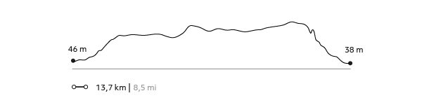
ALTO DEL TORO
Encuentro
-
Hike
-
Moderate
-
Full-day
We travel by van to a steep path facing the Paine River. We begin our trek towards the mountain range passing through an old forest...
More details >ALTO DEL TORO
-
Exploration Path
We travel by van to a steep path facing the Paine River. We begin our trek towards the mountain range passing through an old forest. We continue ascending to an overlook with unparalleled views of the Paine massif and the lakes that surround it. Then, we begin the descent towards the van.
681 m 2.234 ft
-693 m -2.274 ft
411 m 1.348 ft
38 m 125 ftElevation Profile
-
Other options: