The Uyuni Salt Flat: a confluence of history, geology and mind-bending landscapes
In the middle of the Bolivian altiplano, the Uyuni Salt Flat is a dream-like spectacle. It has a prehistoric past. Its geology and breath-taking landscape have been sculpted by the passage of time and the erosion of the wind. Its attractive landscape, surrounded by incredible rock cathedrals or yardangs, volcanoes, lakes and a rich local culture, is a worthy attraction for anyone who embarks on the adventure of visiting the largest salt flat in the world.
By Ladera Sur.
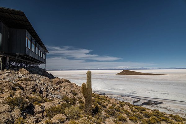
Located in the province of Daniel Campos, in the department of Potosí in southern Bolivia, the Uyuni Salt Flat is considered the highest and largest salt desert on the planet, with an altitude close to 3,700 meters above sea level and a surface area of over 10,500 km2. This makes it a must-see South American destination for travellers.
The mesmerising salt flat is a barren, brilliant white beauty. The horizon is seemingly unending. Juxtaposed with its surroundings of ancient rock formations, geysers and volcanoes, this landscape is a startlingly unique landscape.
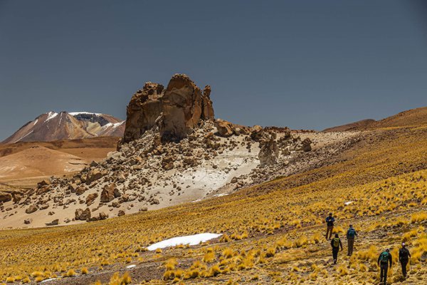
Yardangs: a special geology where the wind and volcanic material are the protagonists
The formation of the Uyuni Salt Lake dates back almost 12 thousand years to a time when salt water predominated. Lake Tauca was at its centre. Its formation was the product of a division of the old super-sized Lake Minchin
some 33,000 years ago. This same lake is believed to have helped form the current Lake Poopó, in addition to the Salar of Coipasa.
In the same way that these developments were responsible for creating what is today the great Uyuni salt desert, the great transformations that the Earth has since undergone also led to the sculpting of curious cathedrals of volcanic rock or yardangs that are found in the vicinity of the salt flat, along the length and breadth of the entire plateau. These have their origin in intense volcanic activity between eight and one million years ago, during the Miocene epoch.
During that time, large explosions released volcanic material in various areas of the highlands, and over time, this material hardened and transformed into what is now known as ignimbrite, a type of volcanic rock that has different properties and responses to erosion. These qualities were confirmed in the surveys conducted by Sergio Gaete, former guide and Territorial Content Manager at Explora.
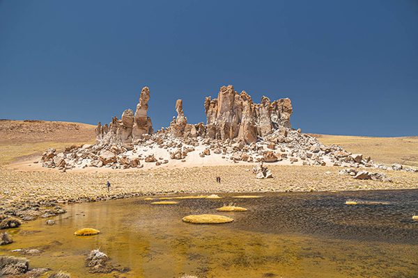
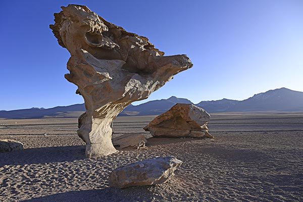
Ignimbrite is responsible for the great rocky cathedrals sculpted by the wind, known as yardangs. They are defined by the Institute of Geography of the Pontificia Universidad Católica de Chile, as: “elongated hills with asymmetric crests aligned parallel to the direction of the predominant wind. They result from the action of deflation and abrasion on a rock mass in desert regions”.
The most spectacular yardang system can be seen to the northeast of the Pastos Grandes lagoon and crater, located 164 km southwest of the Uyuni Salt Flat. This landscape of rocks, some up to 70 m high, has remained standing due to the high desert and steppe climate that prevail in the altiplano.
The past of Pastos Grandes
The incredible rocky landscapes that can be seen today around the Pastos Grandes caldera or lagoon, exist thanks to three major collapses or volcanic eruptions that have occurred throughout history, according to Gaete.
“The oldest collapse on record occurred five million years ago, from which the Chuhuilla ignimbrite originated, covering an area of 1,100 km2, generating a layer of volcanic material one kilometer thick,” the manager of territorial contents of Explora believes, adding that this amount of material had a volume of 1,100 km3.
Later, the second collapse took place five million years ago. It was smaller, generating about 20 km3 of volume of material that gave rise to the Alota ignimbrite rock type. Gaete explains that outcrops of this rock can be seen just 20 km from the Pastos Grandes lagoon.
The third and last collapse of the Pastos Grandes caldera occurred two million years ago, giving rise to the Pastos Grandes ignimbrite. This explosion generated 1,430 km3 of volcanic material, and as explained by Gaete, this eruption deposited a larger volume than the first. Both of these eruptions exceeded the maximum on the index of volcanic explosivity as used today.
“These yardangs are composed of ignimbrites with different resistance to erosion. The weakest and least consolidated rock is located on the lowest layer. Above it the wind then creates a type of geoform called hoodoo, or mega hoodoo because of its large size, but which we colloquially baptize as trees and rock cathedrals, that can measure up to 70 meters high”, argues Sergio Gaete.
The highlands: a blank canvas
This geologically rich backdrop of the Uyuni Salt Flat is today host to spectacular fauna such as the Chilean flamingo (Phoenicopterus chilensis), the Andean flamingo (Phoenicoparrus andinus), the James’s flamingo (Phoenicoparrus jamesi), the suri (Pterocnemia pennata), the Andean condor (Vultur gryphus) and the Andean cat (Leopardus jacobita). This wildlife only enhances the beauty of the sweeping, silent landscape provided by the highlands, a place surrounded by endless horizons and striking silhouettes.
“To witness this landscape, where all the cultural appeal of the altiplano is focused, is like living on a planet that is still being created before your eyes. It is totally out of the ordinary. There is no place on the planet like Uyuni. With its altitude and flatness, nestled in a volcanic cauldron beneath an incredible batholith (giant rock monolith), it is a special and unique place¨, says Guy Wenborne, a prominent Chilean photographer.
The shapes and geomorphological phenomena cut sharp contrasts in that white sea of salt. There are glimpses of land and granite islands in the middle of the salt flat, such as the famous Isla Pescado or Cujiri, with impressive cactus up to 12 m high as well as a cave located in its highest part; or the Incahuasi island, home to cactus forests, tunnels and caves as well as significant archaeological remains of the Inca and Tiahuanacota cultures.
“I loved sunrises¨, the photographer and traveler Wenborne says. I made multiple attempts to capture the experience of how a day is born, from night to first light and then sun rise. I love living the experience of how a day is born in a place like this, because being present and seeing how light interacts with that geography, at that time of day, is wonderful. The beauty is in the essence of the light before light”.
The large hexagons formations of salt visible on the salt flat were created due to the fragmentation of the soil as the salt evaporated towards the surface. This adds to the mirror effect in the salt desert during the southern hemisphere summer. The rock cathedrals or yardangs that are found in these surroundings, make this destination a place with unique characteristics and history that date back millions of years.